Wuwei, Gansu
|
Wuwei
武威市
| |
|---|---|
|
Clockwise from top: South Gate of Wuwei, seat of Gulang County, Wuwei railway station, Hongyashan Reservoir in Minqin County, rock formation in Tianzhu County.
| |
 Location of Wuwei City jurisdiction in Gansu
| |
 Wuwei  Wuwei | |
| Coordinates (Wuwei municipal government): 37°55′44″N 102°38′17″E | |
| Country | People's Republic of China |
| Province | Gansu |
| Municipal seat | Liangzhou District |
| Area | |
| • Prefecture-level city | 33,000 km2 (13,000 sq mi) |
| Population
(2020)
| |
| • Prefecture-level city | 1,464,955 |
| • Density | 44/km2 (110/sq mi) |
| • Urban | 688,697 |
| Time zone | UTC+8 (CST) |
| ISO 3166 code | CN-GS-06 |
| Website | www |


Wuwei (Chinese: 武威; pinyin: Wǔwēi) is a prefecture-level city in northwest central Gansu province. In the north it borders Inner Mongolia, in the southwest, Qinghai. Its central location between three western capitals, Lanzhou, Xining, and Yinchuan makes it an important business and transportation hub for the area. Because of its position along the Hexi Corridor, historically the only route from central China to western China and the rest of Central Asia, many major railroads and national highways pass through Wuwei.
History


In ancient times, Wuwei was called Liangzhou (涼州—the name retained by today's Wuwei's central urban district) and is the eastern terminus of the Hexi Corridor. People began settling here about 5,000 years ago. It was a key link for the Northern Silk Road, and a number of important archaeological finds were uncovered from Wuwei, including ancient copper carts with stone animals. The motifs and types of objects in the Wuwei graves, as well as their earthenware, lacquer, and bronze composition, constitute typical examples of the Han Chinese burial style that can be found all over China. Other graves found along the Hexi Corridor show Xiongnu and other minority influence, which are used to trace regimes such as the Northern Liang. It became an important provincial capital during the Former Han Dynasty as the Hou Hanshu makes clear:
"In the third year [170 CE], Meng Tuo, the Inspector of Liangzhou (modern Wuwei), sent the Assistant Officer Ren She, commanding five hundred soldiers from Dunhuang. He, with the Wuji Major Cao Kuan, and Chief Clerk of the Western Regions, Zhang Yan, brought troops from Yanqi (Karashahr), Qiuci (Kucha), and the Nearer and Further Kingdoms of Jushi (Turfan and Jimasa), altogether numbering more than 30,000, to punish Shule (Kashgar). They attacked the town of Zhenzhong (Arach) but, having stayed for more than forty days without being able to subdue it, they withdrew. Following this, the kings of Shule (Kashgar) killed one another repeatedly and, for its part, the Imperial Government was unable to prevent it."
In 121 BC Han emperor Wudi brought his cavalry here to defend the Hexi Corridor against the Xiongnu Huns. His military success allowed him to expand the corridor westward. Its importance as a stop along the Silk Road made it a crossroads of cultures and ethnic groups from all over central Asia. Numerous Buddhist grottoes and temples in the area attest to its role as a path for bringing Buddhism from India and Afghanistan to China.
During the Three Kingdoms period (184-280), Liangzhou was governed by Ma Teng. After the death of Ma Teng, Ma Chao assumed the post and governed the province for a short time before it fell into the hands of Cao Cao, ruler of Wei Kingdom.
Liangzhou was briefly (from 400 to 421) a state during the Sixteen Kingdoms period.
Famous cultural relics from Wuwei include the Galloping Bronze Horse (铜奔马), Western Xia mausoleums(西夏碑), Wuwei White Towers Temple (白塔寺), Tianti Mountain Grotto (天梯山石窟), Luoshi(Kumārajīva) Temple (罗什寺塔), and the Confucian temple (文庙).
Geography and climate
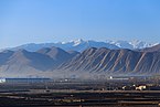
Wuwei is located in the Hexi Corridor between the Tibetan plateau and Mongolian Plateau. The south of Wuwei is higher than the north, with an elevation ranging from 1,020 to 4,874 metres (3,346 to 15,991 ft) above sea-level. Its area is 33,000 km2 (13,000 sq mi). Average annual temperature is 7.8 °C (46.0 °F). The climate is a cold desert climate (Köppen BWk), with precipitation between 60 and 610 mm (2.4 and 24.0 in). Evaporation is from 1,400 to 3,000 mm (55 to 118 in), creating a net loss of water each year. There are 2200–3000 sunlight hours each year and 85–165 frost free days. Summer temperatures can be in excess of 45.0 °C (113.0 °F), in the shade are by no means unheard of.
Southwest of Wuwei, there is a 230 metres (750 ft) thick Tianzhu Formation made of clastics intercalated with sandy shale and shale. Minerals deposits occurring in the vicinity of Wuwei include graphite, iron, titanium, and limestone.
| Climate data for Wuwei (1991–2020 normals, extremes 1971–2010) | |||||||||||||
|---|---|---|---|---|---|---|---|---|---|---|---|---|---|
| Month | Jan | Feb | Mar | Apr | May | Jun | Jul | Aug | Sep | Oct | Nov | Dec | Year |
| Record high °C (°F) | 15.5 (59.9) |
22.3 (72.1) |
28.1 (82.6) |
32.7 (90.9) |
34.2 (93.6) |
35.0 (95.0) |
40.8 (105.4) |
37.3 (99.1) |
34.9 (94.8) |
27.8 (82.0) |
22.8 (73.0) |
17.9 (64.2) |
40.8 (105.4) |
| Mean daily maximum °C (°F) | 0.1 (32.2) |
4.8 (40.6) |
11.4 (52.5) |
18.8 (65.8) |
23.6 (74.5) |
27.8 (82.0) |
29.8 (85.6) |
28.1 (82.6) |
22.9 (73.2) |
16.6 (61.9) |
9.0 (48.2) |
1.9 (35.4) |
16.2 (61.2) |
| Daily mean °C (°F) | −7.2 (19.0) |
−2.7 (27.1) |
4.1 (39.4) |
11.6 (52.9) |
16.7 (62.1) |
21.0 (69.8) |
22.8 (73.0) |
21.1 (70.0) |
15.8 (60.4) |
8.9 (48.0) |
1.3 (34.3) |
−5.4 (22.3) |
9.0 (48.2) |
| Mean daily minimum °C (°F) | −13.3 (8.1) |
−8.9 (16.0) |
−2.2 (28.0) |
4.4 (39.9) |
9.3 (48.7) |
13.5 (56.3) |
15.7 (60.3) |
14.7 (58.5) |
9.9 (49.8) |
2.7 (36.9) |
−4.7 (23.5) |
−10.9 (12.4) |
2.5 (36.5) |
| Record low °C (°F) | −25.3 (−13.5) |
−25.0 (−13.0) |
−19.3 (−2.7) |
−7.7 (18.1) |
−3.0 (26.6) |
2.8 (37.0) |
7.2 (45.0) |
4.3 (39.7) |
−0.8 (30.6) |
−14.4 (6.1) |
−22.7 (−8.9) |
−32.0 (−25.6) |
−32.0 (−25.6) |
| Average precipitation mm (inches) | 2.2 (0.09) |
2.1 (0.08) |
5.7 (0.22) |
9.8 (0.39) |
18.0 (0.71) |
22.5 (0.89) |
34.7 (1.37) |
41.1 (1.62) |
29.1 (1.15) |
10 (0.4) |
3.0 (0.12) |
1.8 (0.07) |
180 (7.11) |
| Average precipitation days (≥ 0.1 mm) | 2.9 | 2.3 | 3.4 | 3.8 | 6.2 | 6.6 | 8.2 | 9.8 | 8.1 | 4.6 | 2.4 | 1.9 | 60.2 |
| Average snowy days | 4.5 | 4.1 | 4.5 | 1.6 | 0.3 | 0 | 0 | 0 | 0 | 1.7 | 3.4 | 3.6 | 23.7 |
| Average relative humidity (%) | 50 | 44 | 40 | 36 | 41 | 47 | 54 | 58 | 61 | 55 | 53 | 54 | 49 |
| Mean monthly sunshine hours | 224.4 | 223.0 | 247.1 | 253.1 | 276.5 | 268.6 | 264.4 | 248.6 | 214.8 | 237.9 | 231.0 | 224.5 | 2,913.9 |
| Percent possible sunshine | 73 | 73 | 66 | 64 | 63 | 61 | 59 | 60 | 59 | 70 | 77 | 76 | 67 |
| Source 1: China Meteorological Administration | |||||||||||||
| Source 2: Weather China | |||||||||||||
A species of stone loach, Triplophysa wuweiensis, is named after Wuwei where it was first discovered.
Administration

1 urban district, 2 counties, 1 autonomous county, 116 towns, and 41 townships
| Map | ||||||
|---|---|---|---|---|---|---|
| Name | Hanzi | Hanyu Pinyin | Population (2010) |
Area (km²) |
Density (/km²) |
|
| Liangzhou District | 凉州区 | Liángzhōu Qū | 1,010,295 | 5,081 | 207.29 | |
| Minqin County | 民勤县 | Mínqín Xiàn | 241,251 | 16,016 | 15.2 | |
| Gulang County | 古浪县 | Gǔlàng Xiàn | 388,720 | 5,287 | 78.13 | |
|
Tianzhu Tibetan Autonomous County |
天祝藏族自治县 | Tiānzhù Zàngzú Zìzhìxiàn |
174,793 | 6,865 | 25.71 | |

Demographics
Population Overview
By 2020, Population 1,464,955 with 38 ethnic groups represented including Han, Hui, Mongol, Tu, Tibetan, etc.
| 2000·The 5th National Census | 2010·The 6th National Census | 2020·The 7th National Census | |||||||
|---|---|---|---|---|---|---|---|---|---|
| County | Population | % | District/County | Population | % | Compared with 5th Census | Population | % | Compared with 6th Census |
| Wuwei County | 992,100 | 53.07% | Liangzhou District | 1,010,295 | 55.67% | - | 885,277 | 60.43% | -125,018↓ |
| Minqin County | No Data | - | Minqin County | 241,251 | 13.29% | - | 178,470 | 12.18% | -62,781↓ |
| Gulang County | No Data | - | Gulang County | 388,718 | 21.41% | - | 250,177 | 17.07% | -138,541↓ |
|
Tianzhu Tibetan Autonomous County |
221,332 | 12.04% |
Tianzhu Tibetan Autonomous County |
174,790 | 9.63% | -46,542↓ | 151,031 | 10.32% | -23,759↓ |
| Entire Region | 1,836,923 | 100% | Entire City | 1,815,054 | 100% | -21,869↓ | 1,464,955 | 100% | -350,099↓ |
Urbanization and Gender Structure
| National Census | Urban Population | Male | Female | Sex | |||
|---|---|---|---|---|---|---|---|
| Total | Urbanization | Total | % | Total | % | ||
| 5th | 370,008 | 20.14% | 949,435# | 51.69% | 887,488# | 48.31% | 106.98 |
| 6th | 500,528 | 27.56% | 933,482 | 51.43% | 881,572 | 48.57% | 105.89 |
| 7th | 688,697 | 47.01% | 740,306 | 50.53% | 724,649 | 49.47% | 102.16 |
| Observation | #No data, estimated based on the published sex ratio | ||||||
Education Level
| National Census | University Education (including associate degree) | High School Education | Secondary Education | Primary Education | illiteracy | |||||
|---|---|---|---|---|---|---|---|---|---|---|
| Total | % | Total | % | Total | % | Total | % | Total | % | |
| 5th | 33,927* | 2.08% | 182,774* | 11.22% | 504,999* | 31.01% | 738,388* | 45.34% | 168,499 | 10.35% |
| 6th | 98,932 | 5.84% | 257,772 | 15.23% | 681,562 | 40.26% | 540,193 | 31.91% | 114,475 | 6.76% |
| 7th | 184,994 | 13.69% | 207,940 | 15.38% | 456,779 | 33.79% | 418,200 | 30.94% | 83,812 | 6.20% |
| Observation | *Estimation, the original data is the number of people educated per 100,000 people. The number of people educated per 100,000 people in universities, high schools, junior high schools, and primary schools is 1847, 9950, 27491, and 40197, respectively | |||||||||
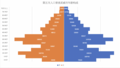
Age Distribution and Population Pyramid
| National Census | 7th | 6th | 5th | |||
|---|---|---|---|---|---|---|
| Age Group(years) | Male | Female | Male | Female | Male | Female |
| 0-4 | 44,485 | 40,263 | 48,981 | 39,046 | 70,504 | 48,496 |
| 5-9 | 46,339 | 40,519 | 53,974 | 41,208 | 100,743 | 84,294 |
| 10-14 | 47,440 | 39,429 | 73,286 | 56,878 | 109,253 | 100,793 |
| 15-19 | 42,418 | 33,600 | 98,852 | 86,983 | 75,924 | 72,156 |
| 20-24 | 31,309 | 29,028 | 81,607 | 82,949 | 50,148 | 50,967 |
| 25-29 | 42,722 | 42,670 | 58,238 | 58,222 | 90,740 | 90,367 |
| 30-34 | 50,031 | 52,066 | 50,724 | 47,871 | 107,026 | 108,502 |
| 35-39 | 42,347 | 42,627 | 86,543 | 86,548 | 85,427 | 86,072 |
| 40-44 | 39,740 | 38,369 | 100,781 | 102,535 | 52,819 | 48,012 |
| 45-49 | 70,821 | 74,010 | 78,779 | 81,645 | 56,282 | 51,909 |
| 50-54 | 83,149 | 87,007 | 48,773 | 44,674 | 42,428 | 41,012 |
| 55-59 | 64,464 | 67,021 | 50,627 | 48,153 | 35,440 | 33,260 |
| 60-64 | 38,398 | 35,821 | 35,973 | 36,379 | 30,846 | 29,633 |
| 65-69 | 40,668 | 40,442 | 28,436 | 28,213 | 22,239 | 22,436 |
| 70-74 | 26,799 | 28,670 | 20,116 | 20,960 | 10,766 | 10,577 |
| 75 or above | 29,176 | 33,107 | 17,797 | 19,308 | 8,466 | 9,449 |
| The following pictures are based on The 5th, 6th, and 7th National Census of Wuwei - Gender and Age Structure |
|---|
|
|


No. of Household
| National Census | No. of Household | Population | No. of ppls/household |
|---|---|---|---|
| 5th | No Data | No Data | 3.95 |
| 6th | 467,040 | 1,748,588 | 3.74 |
| 7th | 529,119 | 1,383,397 | 2.61 |
Wuwei Ethnic Population and Gender
Ethnic Population by County/District(2020)
| County/District | Han | % | Minorities | % |
|---|---|---|---|---|
| Liangzhou District | 870,610 | 98.3% | 14,667 | 1.7% |
| Minqin County | 176,789 | 99.1% | 1,681 | 0.9% |
| Gulang County | 246,503 | 98.5% | 3,674 | 1.5% |
|
Tianzhu Tibetan Autonomous County |
89,762 | 59.4% | 61,269 | 40.6% |
| Wuwei | 1,383,664 | 94.5% | 81,291 | 5.5% |
Gender Data by Ethnicity(2020)
| County/District | Male (Han) | Female (Han) | Sex Ratio (Han) | Male (Minorities) | Female (Minorities) | Sex Ratio (Minorities) |
|---|---|---|---|---|---|---|
| Liangzhou District | 438,898 | 431,712 | 101.7 | 7,620 | 7,047 | 108.1 |
| Minqin County | 90,394 | 86,395 | 104.6 | 915 | 766 | 119.5 |
| Gulang County | 123,481 | 123,022 | 100.4 | 1,706 | 1,968 | 86.7 |
|
Tianzhu Tibetan Autonomous County |
46,638 | 43,124 | 108.1 | 30,654 | 30,615 | 100.1 |
| Wuwei | 699,411 | 684,253 | 102.2 | 40,895 | 40,396 | 101.2 |
Birth Rate, Mortality Rate, and Natural Growth Rate in Wuwei
| Legend | ↑Natural growth rate increased compared to the previous year
↓Natural growth rate decreased compared to the previous year *There is currently no data available |
|---|
| Year | Birth Rate(‰) | Mortality Rate(‰) | Natural Growth Rate(‰) | Trend of Three Rates |
|---|---|---|---|---|
| 2000 | 13.33 | 5.57 | 7.76 |
 Grey Line: Natural Growth Rate |
| 2001 | 11.97 | 5.21 | 6.76↓ | |
| 2002 | * | * | 6.28↓ | |
| 2003 | * | * | 5.59↓ | |
| 2004 | * | * | 5.61↓ | |
| 2005 | * | * | 5.81↑ | |
| 2006 | * | * | 6.29↑ | |
| 2007 | * | * | 6.43↑ | |
| 2008 | * | * | 6.69↑ | |
| 2009 | * | * | 6.69 | |
| 2010 | * | * | 5.36↓ | |
| 2011 | * | * | 5.28↓ | |
| 2012 | 10.52 | 5.23 | 5.29↓ | |
| 2013 | 10.57 | 5.26 | 5.31↑ | |
| 2014 | 10.61 | 5.28 | 5.33↑ | |
| 2015 | 10.81 | 5.31 | 5.50↑ | |
| 2016 | 10.83 | 5.81 | 5.02↓ | |
| 2017 | 11.38 | 6.22 | 5.16↑ | |
| 2018 | 9.42 | 6.18 | 3.24↓ | |
| 2019 | 9.21 | 6.32 | 2.89↓ | |
| 2020 | * | * | -2.12↓ | |
| 2021 | 8.93 | 10.21 | -1.98↑ | |
| 2022 | 7.84 | 10.55 | -2.72↓ | |
| 2023(Expected) | 8.09 | 10.43 | -2.35↑ | |
| 2028(Expected) | 6.63 | 13.32 | -6.70 |
Economy
Consistent sunlight and fertile soil make agriculture one of Wuwei's biggest industries. Other important industries are textiles, metallurgy, and construction materials. Melons, vegetables, wine and livestock are all major agricultural products. Organic farming is a trend with more land being set aside for “green farming” each year. Land use can be broken down into the following:
- 790 square kilometres (310 sq mi) of water
- 34,800 square kilometres (13,400 sq mi) of forest
- 355,300 square kilometres (137,200 sq mi) of grassland.
- 247,000 square kilometres (95,000 sq mi) of “undeveloped” land.
- 39,100 square kilometres (15,100 sq mi) of farmland.
- 8,000 square kilometres (3,100 sq mi) of corn
- 4,000 square kilometres (1,500 sq mi) of vegetables
- 3,000 square kilometres (1,200 sq mi) of melons
- 5,000 square kilometres (1,900 sq mi) for livestock
- 800 square kilometres (310 sq mi) of vineyards
Transport
Railway
There are two railway lines that pass through Wuwei, namely the Lanzhou-Xinjiang Railway and the Gantang-Wuwei Railway. Both are east-west railway lines. Since there are no north-south railway lines crossing Wuwei, there are no railway lines passing through Minqin County which lies in the northern part of Wuwei, therefore, there are no railway stations in Minqin.
There exist various railway stations in Liangzhou District, Gulang County and Tianzhu Tibetan Autonomous County. Wuwei Railway Station (second-class station) is the largest train station in terms of passenger traffic in Wuwei. It is located 303 kilometers east of Lanzhou Station and 1,589 kilometers west of Urumqi Railway Station.
Major Railway Stations in Wuwei
| Station Name | Wuwei Railway Station | Wuwei (S.) Railway Station | Wuwei (E.) Railway Station <Under Construction> | |
|---|---|---|---|---|
| Station Name in Chinese (Chinese Pinyin) | 武威站
(Wǔwēizhàn) |
武威南站
(Wǔwēinānzhàn) |
武威东站
(Wǔwēidōngzhàn) |
|
| Photo |
 |
 |
 |
|
| Location (Chinese) | Yingbin Rd.(迎宾路) | Wunan Town (武南镇) | Fafang Town (发放镇) | |
| Station Class | Second Class | First Class | Second Class | |
| Raliway Line | Lanzhou-Xinjiang Railway | ✓ | ✓ | |
| Gantang-Wuwei Railway | ✓ | ✓ | ||
| Lanzhou-Zhangye Railway | ✓ | |||
| Service | Passenger Transporting | ✓ | ✓ | ✓ |
| Luggage Service | ✓ | |||
| Courier Service | ✓ | |||
| Others | Wuwei Railway Stations was renovated in 2009~2010 at the original site. | China Europe Freight Train | Under construction, expected to be put into operation in June 2024;
High-speed Railway Station |
|
| Station Name | Gulang Railway Station | Gulang (N.) Railway Station
<Under Construction> |
|
|---|---|---|---|
| Station Name in Chinese (Chinese Pinyin) |
古浪站
(Gǔlàngzhàn) |
古浪北站
(Gǔlàngběizhàn) |
|
| Photo | Picture Not Available |
 |
|
| Location (Chinese) | Chengguan St.
(城关街) |
Zhangjiahewanzi Village (张家河湾子村) | |
| Station Class | Fourth Class | - | |
| Raliway Line | Lanzhou-Xinjiang Railway | ✓ | |
| Gantang-Wuwei Railway | |||
| Lanzhou-Zhangye Railway | ✓ | ||
| Service | Passenger Transporting | ✓ | ✓ |
| Luggage Service | |||
| Courier Service | |||
| Others | - | Under construction, expected to be put into operation in June 2024;
High-speed Railway Station |
|
| Station Name | Tianzhu Railway Station | Tianzhu (W.) Railway Station
<Under Construction> |
|
|---|---|---|---|
| Station Name in Chinese (Chinese Pinyin) |
天祝站
(Tiānzhùzhàn) |
天祝西站
(Tiānzhùxīzhàn) |
|
| Photo |
 |
 |
|
| Location (Chinese) | Huazangsi Town
(华藏寺镇) |
Beishuiquan Village
(北水泉村) |
|
| Station Class | Third Class | - | |
| Raliway Line | Lanzhou-Xinjiang Railway | ✓ | |
| Gantang-Wuwei Railway | |||
| Lanzhou-Zhangye Railway | ✓ | ||
| Service | Passenger Transporting | ✓ | ✓ |
| Luggage Service | |||
| Courier Service | |||
| Others | Orginal Name: Huazangsi Railway Station | Under construction, expected to be put into operation in June 2024;
High-speed Railway Station |
|
Highway
| Category | English Name
Chinese Name |
Code | Service Level |
|---|---|---|---|
| National Freeway | Lianhuo Freeway
连霍高速 |
|
In Service |
| Wujin Freeway
武金高速 |
|
In Service | |
| Dingwu Freeway
定武高速 |
|
In Service | |
| Province Freeway | Wuwei Ring Freeway
武威绕城高速 |
|
In Service |
| Beixian Freeway
北仙高速 |
|
In Service | |
| Minhong Freeway
民红高速 |
|
In Service | |
| Leixi Freeway
雷西高速 |
|
Under Construction | |
| National Highway | G312 National Highway
G312 国道 |
G312 | In Service |
| Manda Highway
G569 曼大公路 |
G569 | Under Construction | |
| Dingwu Highway
G667 武定公路 |
G667 | In Service |