U.S. Route 26 in Oregon
U.S. Highway 26 | ||||
|---|---|---|---|---|
|
US 26 highlighted in red
| ||||
| Route information | ||||
| Maintained by ODOT | ||||
| Length | 471.56 mi (758.90 km) | |||
| Major junctions | ||||
| West end |
|
|||
|
|
||||
| East end |
|
|||
| Location | ||||
| Country | United States | |||
| State | Oregon | |||
| Counties | Clatsop, Tillamook, Columbia, Washington, Multnomah, Clackamas, Wasco, Jefferson, Crook, Wheeler, Grant, Baker, Malheur | |||
| Highway system | ||||
| ||||

U.S. Route 26 (US 26) is a major cross-state United States Numbered Highway with its western terminus in the U.S. state of Oregon, connecting US 101 on the Oregon Coast near Seaside with the Idaho state line east of Nyssa. Local highway names include the Sunset Highway No. 47, Mount Hood Highway No. 26, and John Day Highway No. 5 before continuing into Idaho and beyond.
Route description
The western terminus of the highway (and of US 26) is at an interchange with US 101 between Seaside and Cannon Beach. The highway heads east from there through the Oregon Coast Range, providing access to Saddle Mountain and passing through the valleys of the Necanicum and Nehalem rivers. It then crosses over the Oregon Coast Range, where it passes through the Dennis L. Edwards Tunnel, descending into the Tualatin Valley, into the community of Banks.
East of Banks, the highway merges with Oregon Route 6 (OR 6) and becomes a freeway, which passes through the high-tech regions of Washington County. The freeway enters the Portland metropolitan area in the northeast corner of Hillsboro, then passes through the northern part of the city of Beaverton and the communities of Cedar Hills and Cedar Mill near the intersection with the northern terminus of OR 217. Also at this point, MAX Light Rail is adjacent on the north side of the highway for nearly two miles (3.2 km) until it submerges into the Robertson Tunnel.
The highway enters the Portland city limits near the Sylvan-Highlands neighborhood, where it is also joined by OR 8; east of here, the highway descends a steep grade through a canyon which penetrates Portland's Tualatin Mountains; this stretch of the Sunset is coincident with Canyon Road. The highway skirts the southern edge of Portland's Washington Park, providing access to the Oregon Zoo and other attractions. At the bottom of the grade, the highway passes through the Vista Ridge Tunnels into Downtown Portland. Immediately east of the tunnel is an interchange with Interstate 405 (I-405); this interchange is the end of the Sunset Highway.
In Portland, the route overlaps I-405 (Stadium Freeway No. 61) for a short distance before exiting onto city streets, including Arthur Street, to reach the Ross Island Bridge. US 26 leaves the bridge, which is at the beginning of the Mount Hood Highway No. 26, and follows Powell Boulevard, a surface street, to Gresham.
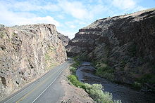
An expressway begins near Gresham and carries US 26 southeast to near Sandy. From Sandy to near Government Camp and Bennett Pass, where US 26 intersects OR 35, it closely follows the historic Barlow Road through the Mount Hood Corridor, and is part of the Mount Hood Scenic Byway. The Mount Hood Highway branches off to the north along OR 35, and the Warm Springs Highway No. 53 carries US 26 southeast through Wapinitia Pass (where it crosses the Pacific Crest Trail), Blue Box Pass, the Warm Springs Indian Reservation, and Agency Plains to Madras. After a short overlap with US 97 (The Dalles-California Highway No. 4), the short Madras-Prineville Highway No. 360 continues southeast to a junction with OR 126 in Prineville.
At that junction, US 26 picks up the Ochoco Highway No. 41, which also follows OR 126 west to US 97 in Redmond. The Ochoco Highway ends at OR 19 near Dayville, from which US 26 follows the John Day Highway No. 5 through John Day to US 20 in Vale. The remainder of US 26 in Oregon overlaps US 20 on the Central Oregon Highway No. 7 to the Idaho state line.
History
An ancient trail passed through the section of the Warm Springs Indian Reservation as part of an extensive Indian trade network linking peoples of the northern Great Basin and Columbia Plateau to those living west of the Cascade Range. Obsidian, bear grass, and slaves were transported over these trails to major trading locations along the Columbia River in exchange for dried salmon, smelt, sturgeon, and decorative sea shells. The long established route was later used by Peter Skene Ogden's fur trapping expeditions in 1825 and 1826. Fur trader Nathaniel Jarvis Wyeth was here in the 1830s. Captain John C. Frémont followed this route on his 1843 explorations for the U.S. and Lieutenant Henry Larcom Abbot headed a Pacific Railroad survey party along it in 1855.
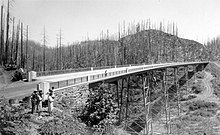
The Sunset Highway portion was under construction by January 1933. Both the Works Progress Administration and Civilian Conservation Corps participated in the construction during the Great Depression. Portions of highway officially opened to the public on September 19, 1941. In 1949, the highway was completed.
The highway was originally named the Wolf Creek Highway after a nearby creek of the same name. The Oregon State Highway Commission renamed it the Sunset Highway at their January 17, 1946, meeting by a unanimous vote. The name is drawn from both the nickname and insignia of the 41st Infantry Division, which was largely drawn from Oregon, and because the highway leads towards the setting sun. The highway was rededicated in honor of the 41st Infantry Division in 1995.
In the 1960s, Powell Boulevard in Portland was proposed as the corridor of the Mount Hood Freeway, which would have replaced US 26. It was cancelled in 1974 following a protests and local opposition. A few ramp stubs from I-5 on the Marquam Bridge were built to prepare for the new freeway and remained in place until the 2010s. The state and county government later considered moving US 26 to Division Street between I-205 and Gresham to improve freeway access. The cancelled freeway included plans to bypass Sandy, which were later revived in the 2000s and 2010s to address congestion issues in the area.
US 26 formerly terminated at a junction with US 30 in Astoria, sharing an alignment with US 101 north of Cannon Beach. The highway was truncated by the American Association of State Highway and Transportation Officials in 2005 following a request from the Oregon Department of Transportation (ODOT). Prior to 2005, US 26 ran through Downtown Portland on the one-way couplet of Market and Clay streets, which carried the Sunset Highway to its end at Naito Parkway (Pacific Highway West No. 1W), turning south there to reach the Ross Island Bridge.
In 2020, US 26 was designated POW/MIA Memorial Highway by the state legislature following a request from the Bend Heroes Foundation and Oregon Veterans Motorcycle Association.
Major intersections
Milepoints are as reported by ODOT and do not necessarily reflect current mileage. Z indicates overlapping mileage due to construction longer than established route, and – indicates negative mileage behind established beginning point. Segments that are locally maintained may be omitted. For routes traversing multiple named state highways, each milepoint is preceded by the corresponding state highway number.
| County | Location | Milepoint | Exit | Destinations | Notes | |||
|---|---|---|---|---|---|---|---|---|
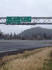
| Clatsop | Cannon Beach Junction | 47 -0.10 |
|
Interchange; Western terminus | ||||
| Necanicum Junction | 47 9.42 |
|
||||||
| Jewell Junction | 47 21.78 |
|
Interchange | |||||
|
Tillamook |
No major junctions | |||||||
|
Washington |
No major junctions | |||||||
|
Columbia |
No major junctions | |||||||
| Washington | | 47 40.91 | Dennis L. Edwards Tunnel | |||||
| Staleys Junction | 47 45.51 |
|
West end of OR 47 overlap | |||||
| Davies Junction | 47 49.47 |
|
Interchange; east end of OR 47 overlap | |||||
| Tillamook Junction | 47 53.33 |
|
Interchange; no westbound entrance | |||||
| | 47 53.62 | West end of freeway | ||||||
| | 47 55.19 | 55 | Dersham Road – Mountaindale | |||||
| North Plains | 47 57.16 | 57 | Glencoe Road – North Plains | |||||
| | 47 58.74 | 59 | Jackson School Road | |||||
| Hillsboro | 47 61.06 | 61 | Helvetia Road, Brookwood Parkway | |||||
| 47 62.46 | 62 | Cornelius Pass Road – Cornelius Pass, West Union | Signed as exits 62A (south) and 62B (north) westbound | |||||
| 47 64.29 | 64 | 185th Avenue – PCC-Rock Creek | ||||||
| Beaverton | 47 65.67– 64.91 |
65 | Bethany Boulevard, Cornell Road | |||||
| 47 67.14 | 67 | Murray Boulevard | ||||||
| 47 68.34 | 68 | Cedar Hills Boulevard – Beaverton | ||||||
| 47 69.19 | 69A |
|
||||||
| 47 69.21 | 69B | Park Way, Barnes Road | ||||||
| 47 70.83 | 71A |
|
Westbound exit and eastbound entrance | |||||
| Multnomah | Portland | 47 71.30 | 71B | Sylvan | Signed as exit 71 eastbound | |||
| 47 72.18 | 72 | Oregon Zoo, World Forestry Center | ||||||
| 47 73.39 | 73 | Canyon Road – Providence Park | Eastbound exit and westbound entrance | |||||
| 47 73.53 | Vista Ridge Tunnels | |||||||
| 47 73.75 | 74 | Market Street (Sunset Highway east) – Portland City Center | Eastbound exit and westbound entrance | |||||
| 47 74.05 61 1.41 |
|
West end of I-405 overlap, exit 1D | ||||||
| 61 1.39 | 12th Avenue | Westbound exit and eastbound entrance | ||||||
| 61 1.29 (city street) |
|
East end of I-405 overlap, exit 1C; eastbound exit & westbound entrance | ||||||
| | East end of freeway | |||||||
| | Broadway Drive – Council Crest | No access from US 26 west | ||||||
| | 6th Avenue, Terwilliger Boulevard – Portland City Center, Keller Auditorium, Oregon Health & Science University, University and V.A. Hospitals | |||||||
|
(city street) 26 0.01 |
Naito Parkway (Pacific Highway West north) | Interchange; westbound exit and eastbound entrance | ||||||
| 26 0.18 |
|
Interchange | ||||||
| 26 0.45 |
|
Interchange | ||||||
| 26 0.76 | Ross Island Bridge over the Willamette River | |||||||
| 26 1.01 |
|
Interchange; eastbound exit to OR 99E north is via 17th Avenue south | ||||||
| 26 1.60 | 17th Avenue south | Interchange; eastbound exit and westbound entrance | ||||||
| 26 1.76 | 17th Avenue north | Westbound exit only | ||||||
| 26 5.04 |
|
|||||||
| 26 5.74 |
|
I-205 exit 19. | ||||||
| Gresham | 26 14.18 |
|
||||||
| Clackamas | | 26 19.54 |
|
Interchange | ||||
| Sandy | 26 24.40 |
|
||||||
| | 26 54.23 | Timberline Lodge National Historic Landmark (OR 173) | ||||||
| | 26 57.45 53 57.45 |
|
Interchange | |||||
| Wasco | | 53 71.27 |
|
|||||
| Jefferson | Madras | 53 117.71 4 92.08 |
|
West end of US 97 overlap | ||||
| 4 92.46 | D Street (OR 361) – Metolius, The Cove Palisades State Park | |||||||
| | 4 97.29 360 0.09 |
|
East end of US 97 overlap | |||||
| Crook | Prineville | 360 26.28 41 18.16 |
|
|||||
| 41 18.75 |
|
|||||||
| 41 19.75 | Prineville Reservoir, Paulina (OR 380) | |||||||
| Wheeler | Mitchell | 41 65.94 |
|
|||||
| Grant | | 41 98.36 5 124.17 |
|
|||||
| Mount Vernon | 5 154.03 |
|
West end of US 395 overlap | |||||
| John Day | 5 162.29 |
|
East end of US 395 overlap | |||||
| Austin Junction | 5 190.67 |
|
||||||
| Baker | | 5 210.54 |
|
|||||
| Malheur | | 5 223.22 | Eldorado Pass | |||||
| Vale | 5 278.21 7 246.39 |
|
West end of US 20 overlap | |||||
| Cairo Junction | 7 258.20 |
|
West end of OR 201 overlap | |||||
| Nyssa | 7 265.97 |
|
East end of OR 201 overlap | |||||
| | 7 266.82 | Idaho state line |
||||||
1.000 mi = 1.609 km; 1.000 km = 0.621 mi
| ||||||||