Trollstigen


Trollstigen (or trollstigvegen; English: The troll path) is a serpentine mountain road and pass in Rauma Municipality, Møre og Romsdal county, Norway.
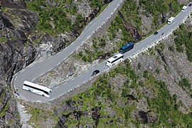
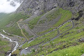
It is part of Norwegian County Road 63 that connects the town of Åndalsnes in Rauma and the village of Valldal in Norddal Municipality. It is a popular tourist attraction due to its steep incline of 10% and eleven hairpin bends up a steep mountainside. During the top tourist season, about 2,500 vehicles pass daily. During the 2012 season, 161,421 vehicles traversed the route, compared to 155,230 vehicles during 2009.
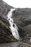
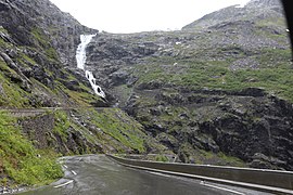
The road is narrow with many sharp bends, and although several bends were widened during 2005 to 2012, vehicles over 12.4 metres (41 ft) long are prohibited from driving the road. During the 2011 and 2012 seasons, buses up to 13.1 metres (43 ft) were temporarily allowed as a trial. At the 700-metre (2,300 ft) plateau there is a car park and several viewing balconies overlooking the bends and the Stigfossen waterfall. Stigfossen falls 320 metres (1,050 ft) down the mountainside. The pass has an elevation of approximately 850 metres (2,790 ft).
Trollstigen is closed during late autumn and winter. A normal operating season stretches from mid-May to October, but may sometimes be shorter or longer due to weather conditions.
Etymology
Trollstigen means the troll path or troll trail, from the Norwegian stig (also spelled sti), from Old Norse stigr.
History

Trollstigen was opened on 31 July 1936, by King Haakon VII after eight years of construction.
A major tourist facility including a restaurant was completed in 2012. Several viewing platforms have been constructed and older constructions improved upon. Trollstigen (along with County Road 63) was officially opened as a national tourist route by the Minister of Transport and Communications on 16 June 2012. Trollstigen itself (and the alpine summits to the west) lies within the Trollstigen landscape protection area, while the alpine area east of Trollstigen, including the Trolltindene range, is part of Reinheimen National Park.
In the summer of 2005, the road was repaired and about 16 million kr was spent on protection against rockfall, making the road safer to drive on.
In June 2021, Telia Norge commissioned an eco-friendly mobile base station powered entirely by solar, wind and hydrogen, therefore providing mobile phone coverage at Trollstigen for the first time ever.
Opening and closing dates


| Year | Open | Closed | Comment |
|---|---|---|---|
| 1994 | 20 May | 27 September | |
| 1995 | 25 May | ||
| 1996 | 24 May | ||
| 1997 | 6 June | 24 September | |
| 1998 | 15 May | 15 October | closed because of snow |
| 1999 | 14 May | 10 September | temporarily closed 9 August because of landslide, early winter closing because of construction work. |
| 2000 | 26 May | 20 August | closed early because of construction work |
| 2001 | 21 May | 21 August | closed early because of construction work |
| 2002 | 23 May | 16 September | Early closing because of maintenance work. |
| 2003 | 28 May | 15 August | closed early because of landslide and flooding |
| 2004 | 29 May | ||
| 2005 | 1 June | 15 November | latest closing since 1992 |
| 2006 | 3 May | ||
| 2007 | 23 May | 17 October | |
| 2008 | 27 May | 4 November | |
| 2009 | 20 May | 23 October | closed because of avalanche |
| 2010 | 28 May | 4 November | |
| 2011 | 13 May | 24 November | |
| 2012 | 1 June | 5 November | |
| 2013 | 22 May | 13 November | |
| 2014 | 8 May | 1 December 8 December | temporarily closed 23 November |
| 2015 | 13 May | 24 November 23 November | |
| 2016 | 25 May | 3 November | Closed because of snow |
| 2017 | 24 May | 13 November 8 November | |
| 2018 | 11 May | 26 October, open again 16 November | closed for the winter 26 October, open again 16 November because of warm weather Closed 2 December because of storm. |
| 2019 | 16 May | 30 October |
Gallery
-
 Trollstigen Visitor Center
 -
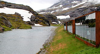 Trollstigen visitor center, with souvenir shops and toilets
 -
 Stigrøra with souvenir sale. In the background the rock formation Trollklørne.
 -
 Alnesreset - the highest point on the mountain pass and municipal boundary.
 -
 Stigfossen with Stigfossbrua seen from below.
 -
 From Trollstigrennet around 1952 (Stein Eriksen with ski pole).
 -
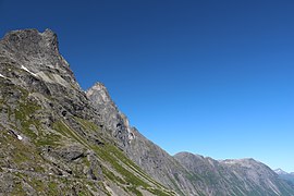
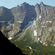 Trollryggen mountains, located between Romsdalen and Trollstigen.
 -
 Acception Document for Trollstigvegen in Romsdal signed by Haakon VII (31 July 1936)
 -
 The visitor center just before the official opening (16 June 2012)
 -
 Works on the viewing platform (2008)
 -
 Trollstigen road signs
 -
 Memorial stone with the text "King Håkon built this road in 1936"
 -
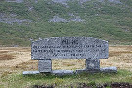 Memorial stone
 -
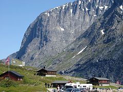
 Viewpoint
 -
 Viewpoint
 -
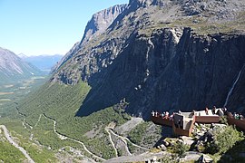
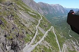
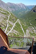 View from the platform
 -
 View from the platform
 -
 Viewpoint
 -
 Viewpoint
 -
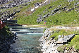 The river
 -
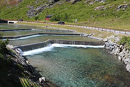 The river
 -
 The river under the viewing platform
 -
-
 The road down seen from the viewing platform
 -
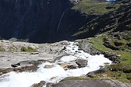
 Waterfall
 -
 Traffic jam
 -
 Traffic jam
 -
 Trollstiggen
 -
 Stigfossen
 -
 Trollstiggen
 -
 Trollstiggen near Stigfossen


