Sonamarg
|
Sonamarg
Sonamarag
Sonmarg
| |
|---|---|
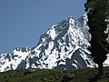
 Northern Sonamarg photographed in 2017
| |
 Sonamarg  Sonamarg | |
| Coordinates: 34.33°N 75.33°E / 34.33; 75.33 | |
| Country | India |
| Union territory | Jammu and Kashmir |
| District | Ganderbal |
| Elevation | 2,730 m (8,960 ft) |
| Population | |
| • Total | 392 |
| Languages | |
| • Official | Kashmiri, Urdu, Hindi, Dogri, English |
| • Spoken | Pahari, Gujari, Shina, Balti, Phustu |
| Time zone | UTC+5:30 (IST) |
| PIN | 191202 |
| Telephone code | +91-1942417- |
| Vehicle registration | JK16 |
Sonamarg (Urdu pronunciation: [soːnaːmərɡ]) or Sonmarg (Urdu pronunciation: [soːnmərg]), known as Sonamarag (Kashmiri pronunciation: [sɔnɨmarɨɡ]; lit. 'meadow of gold') in Kashmiri, is a hill station located in the Ganderbal District of Jammu and Kashmir, India. It is located about 62 kilometers from Ganderbal Town and 80 kilometres (50 mi) northeast of the capital city, Srinagar.
History
Sonamarg had historical significance as a gateway on the ancient Silk Road, connecting Kashmir with Tibet. Today, the hill station is a popular tourist destination amongst fishers and hikers, and following the Kargil War with neighbouring Pakistan in 1999, serves as a strategically important point for the Indian Army.
Geography
The hill station is situated in the Kashmir Valley, at an altitude of 2,730 metres (8,960 ft) and is close to some of the valley's tallest peaks, alongside the Machoi Glacier, Sirbal Peak, Kolahoi Peak, Amarnath Peak and Machoi Peak. Combined with the alpine meadows that bloom in the summer as well as rivers and lakes stocked with fish, Sonamarg is a notable tourist destination in Jammu and Kashmir.
Climate
Given its high altitude and mountainous terrain, Sonamarg experiences the regionally-rare humid continental climate (Köppen: Dfb) with significant rainfall. The average temperature in Sonamarg is 6.5 °C (43.7 °F), and nearly 932 mm (36.7 in) of precipitation falls annually (not counting the heavy snowfall that falls occasionally in winter).
| Climate data for Sonmarg | |||||||||||||
|---|---|---|---|---|---|---|---|---|---|---|---|---|---|
| Month | Jan | Feb | Mar | Apr | May | Jun | Jul | Aug | Sep | Oct | Nov | Dec | Year |
| Mean daily maximum °C (°F) | −5.4 (22.3) |
−3.4 (25.9) |
1.7 (35.1) |
9.3 (48.7) |
17 (63) |
21.7 (71.1) |
24.3 (75.7) |
24.1 (75.4) |
21 (70) |
15 (59) |
7.5 (45.5) |
−0.5 (31.1) |
11.0 (51.9) |
| Daily mean °C (°F) | −8.4 (16.9) |
−7 (19) |
−1.5 (29.3) |
5.6 (42.1) |
11.8 (53.2) |
16.1 (61.0) |
19.1 (66.4) |
19 (66) |
15.3 (59.5) |
9.1 (48.4) |
2.5 (36.5) |
−4 (25) |
6.5 (43.6) |
| Mean daily minimum °C (°F) | −11.3 (11.7) |
−10.5 (13.1) |
−4.6 (23.7) |
2 (36) |
6.7 (44.1) |
10.5 (50.9) |
14 (57) |
13.9 (57.0) |
9.6 (49.3) |
3.3 (37.9) |
−2.4 (27.7) |
−7.5 (18.5) |
2.0 (35.6) |
| Average precipitation mm (inches) | 95 (3.7) |
98 (3.9) |
137 (5.4) |
139 (5.5) |
115 (4.5) |
50 (2.0) |
54 (2.1) |
68 (2.7) |
68 (2.7) |
42 (1.7) |
26 (1.0) |
40 (1.6) |
932 (36.8) |
| Source: Climate Dat [1]
|
|||||||||||||
Demographics
Sonamarg has no permanent settlement and is inaccessible during winter due to heavy snowfall and avalanches. Per the 2011 Census of India, Sonamarg had a seasonal population of 392 (51% male, 49% female), excluding tourists and those working in the tourism industry.
Tourism
Sonamarg provides trekking routes leading to Vishansar Lake, Krishansar Lake, Gangabal Lake and Gadsar Lake in the Himalayas, which are stocked with snowtrout and brown trout. The Sind River meanders here and abounds with trout and mahseer. Ponies can be hired for a trip up to Thajiwas glacier, in the summer. The Yatra to the nearby Amarnath Temple begins in Sonamarg.
Baltal, 15 km east of Sonamarg, is a valley that lies at the foot of the Zoji La pass. Trekkers can also reach the city of Leh—known as "the rooftop of the world"—by crossing over the Zoji La.
The Jammu and Kashmir tourism department organizes river rafting tournaments at Sonamarg throughout the year, which has recently seen the participation of teams from abroad.
Access
Sonamarg is accessible by bus or car from Srinagar, the capital of Jammu and Kashmir, via National Highway 1 (NH 1) and the Zoji La pass. During the winter, heavy snowfall and avalanches block the NH 1, meaning local traffic is only permitted up to Gagangear village, which is the last permanent settlement of this area. The Z-Morh Tunnel is being built to keep the road open year-round, and is due for completion in June 2021.
Gallery
-
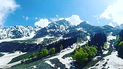
 Sirbal Sonamarg
 -
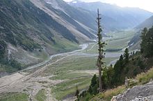
 A view of the Himalayas from Sonmarg valley
 -
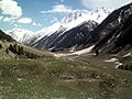
 A view of the mountains from Sonmarg valley
 -
 Sonmarg Thajiwas glacier in May 2013
 -
 Parking at stage 1 of Thajiwas Glacier, 3 km from Sonmarg


