Siegen-Wittgenstein
Siegen-Wittgenstein | |
|---|---|
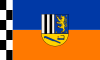 Flag
 Coat of arms
| |
| Country | Germany |
| State | North Rhine-Westphalia |
| Adm. region | Arnsberg |
| Capital | Siegen |
| Area | |
| • Total | 1,131.47 km2 (436.86 sq mi) |
| Population
(31 December 2021)
| |
| • Total | 274,342 |
| • Density | 240/km2 (630/sq mi) |
| Time zone | UTC+01:00 (CET) |
| • Summer (DST) | UTC+02:00 (CEST) |
| Vehicle registration | BLB, SI |
| Website | siegen-wittgenstein.de |
|
County of Wittgenstein
Grafschaft Wittgenstein
| |||||||
|---|---|---|---|---|---|---|---|
| 1174–1357 | |||||||
 Coat of arms of the Counts of Wittgenstein
| |||||||
| Status |
Grafschaft (County) (State of the Holy Roman Empire) |
||||||
| Capital | Wittgenstein Castle | ||||||
| Government | County | ||||||
| Historical era | Middle Ages | ||||||
• Established |
1174 | ||||||
• Merged with Sayn-Sponheim |
1357 | ||||||
| |||||||
Siegen-Wittgenstein is a Kreis (district) in the southeast of North Rhine-Westphalia, Germany. Neighboring districts are Olpe, Hochsauerlandkreis, Waldeck-Frankenberg, Marburg-Biedenkopf, Lahn-Dill, Westerwaldkreis, and Altenkirchen.
History
In 1816–1817, the two districts of Siegen and Wittgenstein were created as parts of the Prussian province of Westphalia. In 1974, the two districts were merged, and in 1984 the name Siegen-Wittgenstein was adopted.
Geography
Geographically, it covers the hills southeast of the Sauerland hills, the Siegerland and Wittgensteiner Land.
Coat of arms
The two upper sections show, to the right, the arms of the Dukes of Nassau, who founded Siegen, and to the left, those of the Counts of Sayn-Wittgenstein. At the bottom a miner's lamp and a coppicing hook are depicted, in reference to the mining and charcoal-burning history of the district.
Towns and municipalities

- Municipalities