Serooskerke, Walcheren
Serooskerke | |
|---|---|
Village | |
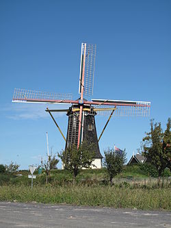 Windmill De Jonge Johannes, Serooskerke
| |
 Flag
 Coat of arms
| |
 Serooskerke Location in the province of Zeeland in the Netherlands
 Serooskerke Serooskerke (Netherlands)
| |
| Coordinates: 51°32′55″N 3°35′43″E | |
| Country | Netherlands |
| Province | Zeeland |
| Municipality | Veere |
| Area | |
| • Total | 9.03 km2 (3.49 sq mi) |
| Elevation | 1.3 m (4.3 ft) |
| Population
(2021)
| |
| • Total | 1,825 |
| • Density | 200/km2 (520/sq mi) |
| Time zone | UTC+1 (CET) |
| • Summer (DST) | UTC+2 (CEST) |
| Postal code | 4353
|
| Dialing code | 0118 |
Serooskerke is a village in the Dutch province of Zeeland. It is a part of the municipality of Veere, and lies about 6 km north of Middelburg.
History
The village was first mentioned before 1207 as Alerdeskirkam, and means "(private) church of Alard (person)". Serooskerke is a circular church village which developed in the 12th century on a ridge. Monastery Mariëndaal was built south of the village in the 13th century. It was destroyed in 1574.
The Dutch Reformed church is a single aisled church with a wide tower. The tower dates from the 15th century. The church was destroyed between 1572 and 1574 and later rebuilt.
Serooskerke was home to 892 people in 1840. It was a separate municipality until 1966, when it was merged with Veere.
In 1966, a farm worker was digging the field near the fire station and discovered a golden coin. Almost 1,100 golden coins from the late 16th and early 17th century were discovered. The municipality was entitled to half the proceeds and built a swimming pool from the money.
Gallery
-
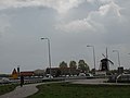 View on Serooskerke
 -
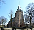 Johanneskerk

