Saint-Martin-d'Uriage
Saint-Martin-d'Uriage | |
|---|---|
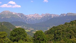 A general view of Saint-Martin-d'Uriage
| |
 Coat of arms
| |
|
Location of Saint-Martin-d'Uriage
| |
 Saint-Martin-d'Uriage  Saint-Martin-d'Uriage | |
| Coordinates: 45°09′08″N 5°50′21″E | |
| Country | France |
| Region | Auvergne-Rhône-Alpes |
| Department | Isère |
| Arrondissement | Grenoble |
| Canton | Oisans-Romanche |
| Intercommunality | CC Le Grésivaudan |
| Government | |
| • Mayor (2020–2026) | Gérald Giraud |
| Area 1
|
29.69 km2 (11.46 sq mi) |
| Population
(Jan. 2021)
|
5,483 |
| • Density | 180/km2 (480/sq mi) |
| Time zone | UTC+01:00 (CET) |
| • Summer (DST) | UTC+02:00 (CEST) |
| INSEE/Postal code |
38422 /38410 |
| Elevation | 320–2,200 m (1,050–7,220 ft) |
| 1 French Land Register data, which excludes lakes, ponds, glaciers > 1 km2 (0.386 sq mi or 247 acres) and river estuaries. | |
Saint-Martin-d'Uriage (French pronunciation: [sɛ̃ maʁtɛ̃ dyʁjaʒ] ) is a commune in the Isère department located in the French Alps, in southeastern France. The nearest major city is Grenoble.
Population
|
|
||||||||||||||||||||||||||||||||||||||||||||||||||||||||||||||||||||||||||||||||||||||||||||||||||||||||||||||||||
| Source: EHESS and INSEE (1968-2017) | |||||||||||||||||||||||||||||||||||||||||||||||||||||||||||||||||||||||||||||||||||||||||||||||||||||||||||||||||||