Provinces of Vietnam
| Provinces and Municipalities of Vietnam Các tỉnh, thành phố trực thuộc Trung ương Việt Nam (Vietnamese) | |
|---|---|
 | |
| Category | Unitary state |
| Location | Vietnam |
| Created |
|
| Number | 58 provinces 5 municipalities (as of 2020) |
| Populations | 338,000 (Bắc Kạn) –9,125,000 (Hồ Chí Minh City) |
| Areas | 822.7 km2 (317.6 sq mi) (Bắc Ninh) – 16,493.7 km2 (6,368.3 sq mi) (Nghệ An) |
| Government |
|
| Subdivisions | |
On the first tier, Vietnam is divided into fifty-eight provinces (tỉnh) and five municipalities under the command of the central government (Vietnamese: thành phố trực thuộc trung ương). Municipalities are the highest-ranked cities in Vietnam. Municipalities are centrally-controlled cities and have special status equal to the provinces.
The provinces are divided into provincial cities (thành phố thuộc tỉnh), towns (thị xã), and rural districts (huyện) as the second-tier units. At the third tier, provincial city or town is divided into ward (phường) and commune (xã), while rural district is divided into townships (thị trấn; capital of that rural district) and communes (xã).
Governance
Provincial Committee of the Communist Party
Provincial Committee of the Communist Party (Đảng bộ Đảng Cộng sản cấp tỉnh or Tỉnh ủy Đảng Cộng sản) is a provincial subordinate of the Communist Party of Vietnam. Since Vietnam is a one party state, the provincial committee of the Communist Party is the most prominent organ of provincial governance.
Each provincial committee of the Communist Party is headed by a Secretary (Bí thư). The Secretary is de facto leader of the province.
People's Council
The legislative branch of a province is the People's Council (Hội đồng Nhân dân or HDND for short). The People's Council votes on the policy, regulations and orders for development of the province.
Members of People's Council are called delegates or councillors (đại biểu) and are elected by people living within that province. It is equivalent to the legislative National Assembly of Vietnam. The People's Council is headed by a Chairman (Chủ tịch) and a Vice Chairman (Phó Chủ tịch).
The number of councillors varies from province to province, depending on the population of that province. The People's Council appoints a People's Committee, which acts as the executive arm of the provincial governance. This arrangement is a somewhat simplified version of the situation in Vietnam's national government. Provincial governments are subordinates to the central government.
People's Committee
The executive branch of a province is the People's Committee (Uỷ ban Nhân dân or UBND for short). The People's Committee is responsible for implementing policy and executing laws and orders. The People's Committee is equivalent to the executive Government of Vietnam. People's Committee also manages the provincial departments (Sở) which are equivalent to the Ministries.
Members of the People's Committee are called commissioners (Ủy viên). The People's Committee is headed by a Chairman (Chủ tịch) and Vice Chairmen (Phó Chủ tịch), and consists of between 4 and 7 commissioners. The number of commissioners depends on the population of the province. The chairman and Vice Chairmen of the People's Committee are also councillors of the People's Council.
People's Court
The judiciary branch of a province is the People's Court (Tòa án Nhân dân or TAND for short). The People's Court is responsible for judiciary processes and trials. The People's Court is equivalent to the judiciary Supreme People's Court of Vietnam.
The People's Court is headed by a Chief Judge (Chánh án) and consists of a number of judges (thẩm phán).
Police Department
Provincial police department is under direct command of the Ministry of Public Security.
State Treasury
Provincial Military Command
List and statistics

Provinces of Vietnam Island areas: *-Bạch Long Vĩ Island (Bạch Long Vĩ District, Haiphong Municipality [3]) **-Phú Quý Islands (Phú Quý District, Bình Thuận Province [46]) ***-Côn Đảo Islands (Côn Đảo District, Bà Rịa - Vũng Tàu Province [51]) ****-Phú Quốc Island (Phú Quốc City, Kiên Giang Province [58]) *****-Thổ Chu Islands (Thổ Châu Commune, Phú Quốc City, Kiên Giang Province [58]) ✱-Paracel Islands (Hoàng Sa District, Đà Nẵng Municipality [4]) ✱✱-Spratly Islands (Trường Sa District, Khánh Hòa Province [43]) |
According to the census results of April 1, 2023, the population of Vietnam is 103,403,000 people. The most populous top-level administrative unit in Vietnam is Hồ Chí Minh City, one of the five centrally governed cities. It has 9,125,000 people living within its official boundaries. The second most populous administrative unit is the recently expanded Hà Nội with 8,146,000 people. Prior to the expansion of the capital city, this rank belonged to Thanh Hóa with 3,689,000 people. The least populous is Bắc Kạn, a mountainous province in the remote northeast with 338,000 people.
In land area, the largest province is Nghệ An, which runs from the city of Vinh up the wide Sông Cả valley. The smallest is Bắc Ninh, located in the populous Red River Delta region.
Per capita personal income 2022 (Vietnamese đồng/month): Binh Duong 8,076,000, Ha Noi 6,423,000, Ho Chi Minh City 6,392,000, Dong Nai 6,346,000, Hai Phong 5,897,000, Da Nang 5,807,000, Bac Ninh 5,470,000, Can Tho 5.324,000, Vinh Phuc 5,194,000, Nam Dinh 5,100,000, Hai Duong 4,936,000, Ninh Binh 4,893,000, Ba Ria Vung Tau 4,815,000, Quang Ninh 4,811,000...
GDP Per capita 2022 (Vietnamese đồng/ year): Ba Ria Vung Tau 331,100,000, Quang Ninh 197,600,000, Hai Phong 175,000,000, Bac Ninh 170,000,000, Binh Duong 166,000,000...
GDP/GRDP 2022 (Vietnamese đồng/year): Ho Chi Minh City 1,479,000,000,000, Ha Noi 1,196,000,000,000, Binh Duong 459,000,000,000, Dong Nai 435,000,000,000, Ba Ria Vung Tau 390,000,000,000, Hai Phong 365,500,000,000, Quang Ninh 269,000,000,000...
Economic growth (2017-2021): Hai Phong 14,162 %/year, Bac Giang 13,274 %/year, Thanh Hoa 11,338%/ year, Quang Ninh 10,708 %/year, Ninh Thuan 10,216%/ year...
Economic growth (2022): Khanh Hoa 20,7%, Bac Giang 19,3%, Da Nang 14,05%, Hau Giang 13,94%, Hung Yen, 13,41%, Can Tho 12,64%, Thanh Hoa 12,51%, Hai Phong 12,32%,...
Economic growth (9 months of 2023): Hau Giang 13,3%, Bac Giang 12,25%, Hai Phong 10,08%, Quang Ninh 9,88%, Khanh Hoa 9,17%, Nam Dinh 9,06%, Ha Nam 8,95%, Phu Yen 8,87%, Ninh Thuan 8,67%, Hung Yen 8,61%, Tra Vinh 8,51%, Thanh Hoa 7,72%, Thai Binh 7,72%, Ca Mau 7,72%,...
HDI (2020): Ha Noi 0,799, Ho Chi Minh City 0,795, Ba Ria Vung Tau 0,793, Hai Phong 0,782, Da Nang 0,779, Quang Ninh 0,769, Bac Ninh 0,768,...
The following is a table of Vietnam's provinces broken down by population and area, April 1, 2023, based on 2023.04.01 Census and 2018 area data from Ministry of Natural Resources and Environment.
| Province/city | Number on map |
Administrative center |
Area (in km2) |
Population |
Density (/km2) |
% Urban |
HDI (2012) |
GDP per capita (2011 PPP US$) |
Region |
|---|---|---|---|---|---|---|---|---|---|
| Bắc Giang province | 20 | Bắc Giang | 3,895.59 | 1,884,000 | 463 | 11.4 | 0.711 | 1,909.44 | Northeast |
| Bắc Kạn province | 14 | Bắc Kạn | 4,859.96 | 338,000 | 65 | 20.7 | 0.685 | 1,766.68 | |
| Cao Bằng province | 10 | Cao Bằng | 6,700.26 | 576,000 | 79 | 23.3 | 0.653 | 1,564.27 | |
| Hà Giang province | 9 | Hà Giang | 7,929.48 | 910,000 | 108 | 15.9 | 0.586 | 1,083.72 | |
| Lạng Sơn province | 11 | Lạng Sơn | 8,310.09 | 828,000 | 94 | 20.4 | 0.707 | 2,201.98 | |
| Phú Thọ province | 17 | Việt Trì | 3,534.56 | 1,515,000 | 414 | 18.1 | 0.715 | 1,916.23 | |
| Quảng Ninh province | 21 | Hạ Long | 6,178.21 | 1,387,000 | 214 | 64.1 | 0.784 | 7,834.55 | |
| Thái Nguyên province | 15 | Thái Nguyên | 3,526.64 | 1,356,000 | 365 | 31.9 | 0.741 | 2,547.11 | |
| Tuyên Quang province | 13 | Tuyên Quang | 5,867.90 | 1,056,000 | 134 | 13.8 | 0.699 | 1,948.18 | |
| Lào Cai province | 8 | Lào Cai | 6,364.03 | 898,000 | 115 | 23.5 | 0.670 | 2,767.55 | Northwest |
| Yên Bái province | 12 | Yên Bái | 6,887.46 | 950,000 | 119 | 19.8 | 0.657 | 1,845.51 | |
| Điện Biên province | 6 | Điện Biên Phủ | 9,541.25 | 705,000 | 63 | 14.4 | 0.611 | 1,589.03 | |
| Hòa Bình province | 22 | Hòa Bình | 4,590.57 | 979,000 | 186 | 15.7 | 0.715 | 2,343.13 | |
| Lai Châu province | 7 | Lai Châu | 9,068.79 | 527,000 | 51 | 17.8 | 0.560 | 1,081.84 | |
| Sơn La province | 16 | Sơn La | 14,123.49 | 1,356,000 | 88 | 13.8 | 0.634 | 1,773.90 | |
| Bắc Ninh province | 19 | Bắc Ninh | 822.71 | 1,447,000 | 1,664 | 27.5 | 0.771 | 4,451.41 | Red River Delta |
| Hà Nam province | 26 | Phủ Lý | 861.93 | 945,000 | 989 | 16.7 | 0.724 | 2,131.93 | |
| Hải Dương province | 24 | Hải Dương | 1,668.24 | 2,003,000 | 1,134 | 25.2 | 0.746 | 2,513.92 | |
| Hưng Yên province | 23 | Hưng Yên | 930.22 | 1,340,000 | 1,347 | 12.2 | 0.743 | 2,503.79 | |
| Nam Định province | 27 | Nam Định | 1,668.57 | 1,852,000 | 1,067 | 18.2 | 0.726 | 1,904.97 | |
| Ninh Bình province | 28 | Ninh Bình | 1,386.79 | 1,102,000 | 708 | 21 | 0.733 | 2,478.79 | |
| Thái Bình province | 25 | Thái Bình | 1,586.35 | 1,934,000 | 1,173 | 10.6 | 0.738 | 2,090.86 | |
| Vĩnh Phúc province | 18 | Vĩnh Yên | 1,235.87 | 1,296,000 | 932 | 25.6 | 0.764 | 3,990.61 | |
| Hà Nội city | 1 | Hoàn Kiếm District | 3,358.60 | 8,146,000 | 2,398 | 49.2 | 0.794 | 3,923.21 | |
| Hải Phòng city | 3 | Hồng Bàng District | 1,561.76 | 2,138,000 | 1,299 | 45.6 | 0.773 | 3,849.18 | |
| Hà Tĩnh province | 31 | Hà Tĩnh | 5,990.67 | 1,402,000 | 215 | 19.5 | 0.725 | 2,117.32 | North Central Coast |
| Nghệ An province | 30 | Vinh | 16,481.41 | 3,399,000 | 202 | 14.7 | 0.715 | 2,379.59 | |
| Quảng Bình province | 32 | Đồng Hới | 8,065.3 | 992,000 | 112 | 21 | 0.716 | 2,203.01 | |
| Quảng Trị province | 33 | Đông Hà | 4,621.72 | 687,000 | 137 | 30.9 | 0.696 | 2,672.10 | |
| Thanh Hóa province | 29 | Thanh Hóa | 11,114.65 | 3,689,000 | 328 | 14.9 | 0.716 | 2,434.69 | |
| Thừa Thiên-Huế province | 34 | Huế | 4,902.44 | 1,257,000 | 230 | 49.5 | 0.735 | 3,072.58 | |
| Đắk Lắk province | 41 | Buôn Ma Thuột | 13,030.50 | 2,016,000 | 143 | 24.7 | 0.708 | 2,555.78 | Central Highlands |
| Đắk Nông province | 42 | Gia Nghĩa | 6,509.27 | 670,000 | 96 | 15.2 | 0.710 | 3,000.70 | |
| Gia Lai province | 38 | Pleiku | 15,510.99 | 1,586,000 | 98 | 29 | 0.689 | 3,023.20 | |
| Kon Tum province | 37 | Kon Tum | 9,674.18 | 589,000 | 56 | 32 | 0.656 | 2,075.42 | |
| Lâm Đồng province | 44 | Đà Lạt | 9,783.34 | 1,390,000 | 133 | 39.2 | 0.735 | 3,331.80 | |
| Bình Định province | 39 | Quy Nhon | 6,066.21 | 1,679,000 | 245 | 31.9 | 0.742 | 3,089.10 | South Central Coast |
| Bình Thuận province | 46 | Phan Thiết | 7,943.93 | 1,498,000 | 155 | 38.1 | 0.732 | 3,090.17 | |
| Khánh Hòa province | 43 | Nha Trang | 5,137.79 | 1,371,000 | 240 | 42.2 | 0.752 | 4,180.68 | |
| Ninh Thuận province | 45 | Phan Rang–Tháp Chàm | 3,355.34 | 720,000 | 176 | 35.8 | 0.695 | 2,402.34 | |
| Phú Yên province | 40 | Tuy Hòa | 5,023.42 | 1,056,000 | 174 | 28.7 | 0.728 | 2,541.80 | |
| Quảng Nam province | 35 | Tam Kỳ | 10,574.74 | 1,697,000 | 141 | 25.4 | 0.745 | 3,192.34 | |
| Quảng Ngãi province | 36 | Quảng Ngãi | 5,155.78 | 1,355,000 | 239 | 16.3 | 0.718 | 3,516.44 | |
| Đà Nẵng city | 4 | Hải Châu District | 1,284.88 | 1,294,000 | 883 | 87.2 | 0.803 | 4,811.58 | |
| Bà Rịa–Vũng Tàu province | 51 | Bà Rịa | 1,980.98 | 1,303,000 | 580 | 58.4 | 0.901 | 36,786.39 | Southeast |
| Bình Dương province | 49 | Thủ Dầu Một | 2,694.64 | 2,564,000 | 901 | 80 | 0.751 | 3,663.54 | |
| Bình Phước province | 47 | Đồng Xoài | 6,876.76 | 1,313,000 | 145 | 23.7 | 0.734 | 3,606.56 | |
| Đồng Nai province | 50 | Biên Hòa | 5,863.60 | 3,227,000 | 528 | 32.9 | 0.763 | 3,485.16 | |
| Tây Ninh province | 48 | Tây Ninh | 4,041.25 | 1,207,000 | 289 | 17.7 | 0.744 | 4,058.65 | |
| Hồ Chí Minh City | 2 | District 1 | 2,061.41 | 9,125,000 | 4,363 | 79.2 | 0.820 | 7,147.09 | |
| An Giang province | 56 | Long Xuyên | 3,536.68 | 2,057,000 | 540 | 31.6 | 0.730 | 3,791.46 | Mekong Delta |
| Bạc Liêu province | 62 | Bạc Liêu | 2,669.01 | 1,105,000 | 340 | 27.7 | 0.742 | 3,701.98 | |
| Bến Tre province | 55 | Bến Tre | 2,394.81 | 1,331,000 | 538 | 9.8 | 0.750 | 2,978.48 | |
| Cà Mau province | 63 | Cà Mau | 5,221.19 | 1,369,000 | 229 | 22.7 | 0.743 | 3,121.66 | |
| Đồng Tháp province | 53 | Cao Lãnh | 3,383.85 | 1,838,000 | 473 | 19.1 | 0.718 | 2,240.56 | |
| Hậu Giang province | 59 | Vị Thanh | 1,621.70 | 853,000 | 452 | 25.4 | 0.743 | 2,943.84 | |
| Kiên Giang province | 58 | Rạch Giá | 6,348.78 | 1,789,000 | 271 | 28.3 | 0.750 | 4,336.43 | |
| Long An province | 52 | Tân An | 4,494.94 | 1,730,000 | 376 | 16.1 | 0.764 | 4,012.39 | |
| Sóc Trăng province | 61 | Sóc Trăng | 3,311.88 | 1,256,000 | 362 | 32.4 | 0.715 | 2,835.46 | |
| Tiền Giang province | 54 | Mỹ Tho | 2,510.61 | 1,898,000 | 703 | 14 | 0.770 | 3,781.77 | |
| Trà Vinh province | 60 | Trà Vinh | 2,358.26 | 1,067,000 | 428 | 17.2 | 0.717 | 2,662.89 | |
| Vĩnh Long province | 57 | Vĩnh Long | 1,525.73 | 1,100,000 | 670 | 16.6 | 0.757 | 3,360.01 | |
| Cần Thơ city | 5 | Ninh Kiều District | 1,438.96 | 1,456,000 | 858 | 69.7 | 0.788 | 6,260.52 |
See also List of postal codes in Vietnam
Regions
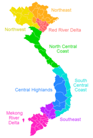
The Vietnamese government often groups the various provinces into eight regions, which are often grouped into three macro-regions: Northern, Central and Southern. These regions are not always used, and alternative classifications are possible. The regions include:
| Macro-region | Region | provinces included | Area (in km2) | Population (April 1, 2023) | Population density (people /km2) |
Notes |
|---|---|---|---|---|---|---|
| Northern Vietnam (Bắc Bộ, Miền Bắc) | Northwest (Tây Bắc Bộ) | 44,301.10 | 5,415,000 | 100.37 | contains inland provinces in the west of Vietnam's northern part. Two of them are along Vietnam's border with Laos, and three border China (Dien Bien borders both China and Laos). | |
| Northeast (Đông Bắc Bộ) | 50,684.10 | 9,850,000 | 169.05 | contains most of the mountainous provinces that lie to north of the highly populated Red River lowlands. Four of them are along Vietnam's border with China. | ||
| Red River Delta (Đồng Bằng Sông Hồng) | 14,957.70 | 22,203,000 | 1,318.00 | contains the small but populous provinces along the mouth of the Red River. The Red River Delta has the smallest area but highest population and population density of all regions. It is also the only region without any land borders with neighbouring countries. | ||
| Central Vietnam (Trung Bộ, Miền Trung) | North Central (Bắc Trung Bộ) | 51,455.60 | 11,426,000 | 203.53 | contains the coastal provinces in the northern half of Vietnam's narrow central part. They all stretch from the coast in the east to Laos in the west. | |
| South Central Coast (Duyên hải Nam Trung Bộ) | 44,376.80 | 10,670,000 | 206.98 | contains the coastal provinces in the southern half of Vietnam's central part. One province borders Laos. | ||
| Central Highlands (Tây Nguyên) | 54,641.00 | 6,251,000 | 102.63 | contains the mountainous provinces to the west of south-central Vietnam. There are a significant number of ethnic minorities in the region. One province is along Vietnam's border with Laos, and four border Cambodia (Kon Tum borders both Laos and Cambodia). | ||
| Southern Vietnam (Nam Bộ, Miền Nam) | Southeast (Đông Nam Bộ, Miền Đông) | 23,590.70 | 18,739,000 | 683.65 | contains those parts of lowland southern Vietnam which are north of the Mekong delta. Two provinces border Cambodia. | |
|
Mekong River Delta (Đồng Bằng Sông Cửu Long) or Southwest (Tây Nam Bộ, Miền Tây) |
40,576.00 | 18,849,000 | 434.00 | is Vietnam's southernmost region, mostly containing small but populous provinces in the delta of the Mekong. It is sometimes referred to as the Southwest region (Tây Nam Bộ). Four provinces border Cambodia. |
^† Municipality (thành phố trực thuộc trung ương)
Historical provinces of Vietnam
- Ái Châu - existed during the third Chinese domination.
- An Xuyên - existed from 1956 until the Vietnamese reunification of 1976.
- Biên Hòa - existed from 1832 until the Vietnamese reunification of 1976.
- Bình Trị Thiên - administrative grouping of Quảng Bình, Quảng Trị and Thừa Thiên provinces between 1976 and 1992.
- Bình Tuy - existed from 1956 until the Vietnamese reunification of 1976.
- Chợ Lớn - existed from 1900 until 1957.
- Chương Thiện - existed from 1961 until the Vietnamese reunification of 1976.
- Cửu Long - administrative grouping of Vĩnh Long and Vĩnh Bình provinces between 1976 and 1992.
- Định Tường - existed from 1832 until the Vietnamese reunification of 1976.
- Gia Định - existed from 1832, became Hồ Chí Minh City following the Vietnamese reunification of 1976.
- Gò Công - existed from 1900 until the Vietnamese reunification of 1976.
- Hà Bắc - administrative grouping of Bắc Giang and Bắc Ninh provinces between 1962 and 1996.
- Hà Tây - existed from 1965 to 1975 and 1991 until 2008, when it was merged into Hà Nội.
- Hải Hưng - administrative grouping of Hải Dương and Hưng Yên provinces between 1968 and 1996.
- Hậu Nghĩa - existed from 1963 until the Vietnamese reunification of 1976.
- Long Khánh - existed from 1956, became Đồng Nai province following the Vietnamese reunification of 1976.
- Minh Hải - administrative grouping of Cà Mau and Bạc Liêu provinces between 1976 and 1996.
- Nghệ Tĩnh - administrative grouping of Nghệ An and Hà Tĩnh provinces between 1976 and 1991.
- Phu Bon - in 1962 split from Pleiku province until 1976.
- Phước Long - existed from 1956 until the Vietnamese reunification of 1976.
- Phước Thành - existed from 1959 until 1965.
- Phước Tuy - existed from 1956 until the Vietnamese reunification of 1976.
- Quảng Tín - existed from 1962 until the Vietnamese reunification of 1976.
- Sa Đéc - existed from 1900 until the Vietnamese reunification of 1976.
- Sông Bé - administrative grouping of Bình Dương and Bình Phước provinces between 1976 and 1997.
- Tân An - existed from 1900 until 1956.
- Vĩnh Bình - existed from 1956 until the Vietnamese reunification of 1976.