Pasil
Pasil | |
|---|---|
| Municipality of Pasil | |
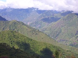 Pasil River Valley
| |
 Flag
| |
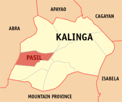 Map of Kalinga with Pasil highlighted
| |
|
OpenStreetMap
| |
 Pasil Location within the Philippines
| |
| Coordinates: 17°23′22″N 121°09′35″E | |
| Country | Philippines |
| Region | Cordillera Administrative Region |
| Province | Kalinga |
| District | Lone district |
| Barangays | 14 (see Barangays) |
| Government | |
| • Type | Sangguniang Bayan |
| • Mayor | Alfredo B. Malannag Jr. |
| • Vice Mayor | Venancio O. Magangat |
| • Representative | Allen Jesse C. Mangaoang |
| • Municipal Council | Members |
| • Electorate | 7,212 voters (2022) |
| Area | |
| • Total | 189.00 km2 (72.97 sq mi) |
| Elevation | 971 m (3,186 ft) |
| Highest elevation | 2,000 m (7,000 ft) |
| Lowest elevation | 357 m (1,171 ft) |
| Population
(2020 census)
| |
| • Total | 10,577 |
| • Density | 56/km2 (140/sq mi) |
| • Households | 2,066 |
| Economy | |
| • Income class | 5th municipal income class |
| • Poverty incidence |
18.15 |
| • Revenue | ₱ 100.5 million (2020) |
| • Assets | ₱ 112.9 million (2020) |
| • Expenditure | ₱ 78.11 million (2020) |
| • Liabilities | ₱ 32.68 million (2020) |
| Service provider | |
| • Electricity | Kalinga - Apayao Electric Cooperative (KAELCO) |
| Time zone | UTC+8 (PST) |
| ZIP code | 3803 |
| PSGC | |
| IDD : area code | +63 (0)74 |
| Native languages | Ilocano Tagalog |
| Website | www |
Pasil, officially the Municipality of Pasil, is a 5th class municipality in the southwestern part of the Kalinga. It is bounded on the north by the municipality of Balbalan, on the south by the municipality of Tinglayan, on the east by Tabuk city, and on the west by the province of Abra and south-western part of the municipality of Sadanga, Mountain Province. According to the 2020 census, it has a population of 10,577 people.
Geography
Barangays
Pasil is politically subdivided into 14 barangays. Each barangay consists of puroks and some have sitios.
- Ableg
- Bagtayan
- Balatoc
- Balinciagao Norte
- Balanciagao Sur
- Cagaluan
- Colayo
- Dalupa
- Dangtalan
- Galdang (Casaloan)
- Guina-ang (Poblacion)
- Magsilay
- Malucsad
- Pugong
Climate
| Climate data for Pasil, Kalinga | |||||||||||||
|---|---|---|---|---|---|---|---|---|---|---|---|---|---|
| Month | Jan | Feb | Mar | Apr | May | Jun | Jul | Aug | Sep | Oct | Nov | Dec | Year |
| Mean daily maximum °C (°F) | 21 (70) |
23 (73) |
24 (75) |
26 (79) |
26 (79) |
25 (77) |
24 (75) |
24 (75) |
24 (75) |
24 (75) |
23 (73) |
21 (70) |
24 (75) |
| Mean daily minimum °C (°F) | 14 (57) |
15 (59) |
16 (61) |
17 (63) |
19 (66) |
19 (66) |
19 (66) |
19 (66) |
19 (66) |
17 (63) |
16 (61) |
15 (59) |
17 (63) |
| Average precipitation mm (inches) | 23 (0.9) |
28 (1.1) |
33 (1.3) |
64 (2.5) |
232 (9.1) |
242 (9.5) |
258 (10.2) |
266 (10.5) |
245 (9.6) |
201 (7.9) |
87 (3.4) |
69 (2.7) |
1,748 (68.7) |
| Average rainy days | 8.3 | 8.0 | 10.8 | 15.2 | 23.7 | 26.1 | 27.0 | 25.8 | 23.5 | 17.3 | 13.7 | 12.1 | 211.5 |
| Source: Meteoblue | |||||||||||||
Demographics
| Year | Pop. | ±% p.a. |
|---|---|---|
| 1970 | 5,557 | — |
| 1975 | 6,755 | +3.99% |
| 1980 | 6,872 | +0.34% |
| 1990 | 7,572 | +0.97% |
| 1995 | 8,935 | +3.15% |
| 2000 | 9,360 | +1.00% |
| 2007 | 10,084 | +1.03% |
| 2010 | 9,626 | −1.68% |
| 2015 | 9,644 | +0.04% |
| 2020 | 10,577 | +1.83% |
| Source: Philippine Statistics Authority | ||
In the 2020 census, the population of Pasil, Kalinga, was 10,577 people, with a density of 56 inhabitants per square kilometre or 150 inhabitants per square mile.
Economy
Government
Local government
Pasil, belonging to the lone congressional district of the province of Kalinga, is governed by a mayor designated as its local chief executive and by a municipal council as its legislative body in accordance with the Local Government Code. The mayor, vice mayor, and the councilors are elected directly by the people through an election which is being held every three years.
Elected officials
| Position | Name |
|---|---|
| Congressman | Allen Jesse C. Mangaoang |
| Mayor | Alfredo B. Malannag Jr. |
| Vice-Mayor | Theodoro A. Mosing |
| Councilors | Marlo P. Bagni |
| Robert Bilarmino D. Ganito | |
| Speedy D. Lapaddic | |
| Shirley T. Taclawan | |
| Washington B. Bakidan | |
| Cecilia C. Bawagan | |
| Leonardo A. Banatao | |
| Ronnie B. Bawalan |
Folklore
In an earlier time, Kabunian–the supreme deity of the Kalinga–left a drop of water upon an ancient tree he passed on one of his travels. This drop trickled down and with a great force akin to magnetism, attracted nearby brooks and rivulets to form what is now called the Pasil River.