Mount Aniakchak
| Aniakchak Caldera | |
|---|---|
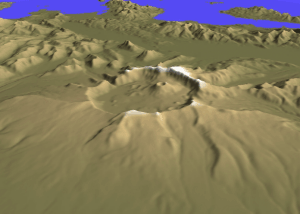
 Mount Aniakchak caldera
| |
| Highest point | |
| Elevation | 4,232 ft (1,290 m) |
| Coordinates | 56°51′47″N 158°07′47″W |
| Geography | |
 Aniakchak Caldera Location in Alaska
| |
| Location | Aniakchak National Monument and Preserve, Alaska, USA |
| Parent range | Aleutian Range |
| Topo map | USGS Chignik D-1 |
| Geology | |
| Mountain type | Caldera (Stratovolcano) |
| Volcanic arc/belt | Aleutian Arc |
| Last eruption | May to June 1931 |
| Designated | November 1967 |
Mount Aniakchak (Russian: Аниакчак) is a 3,600-year-old volcanic caldera approximately 10 kilometers (6 mi) in diameter, located in the Aleutian Range of Alaska, United States. Although a stratovolcano by composition, the pre-existing mountain collapsed in a major eruption forming the caldera. The area around the volcano is the Aniakchak National Monument and Preserve, maintained by the National Park Service. In November 1967, Aniakchak Caldera was designated as a National Natural Landmark by the National Park Service.
Eruptive history
Little is known about the ancestral (Pleistocene) Aniakchak. The volcanic center has been active for at least 850,000 years. It was a moderate-sized composite volcano consisted of basaltic andesite to dacite lava flows and fragmental rocks erupted in Vulcanian, Strombolian and effusive styles. The width of Birthday Creek valley suggests the possible existence of a small late Pleistocene caldera. Postglacial (Holocene) Aniakchak produced two major ignimbrite-forming eruptions, Aniakchak I and Aniakchak II.
Pre-caldera history
Aniakchak I, dated between 9,500 and 7,000 year BP, was formed by andesite pyroclastic flows during one or a few closely spaced eruptions. The volume of Aniakchak I is unknown, and it remains unclear whether a caldera was formed.
Series of closely spaced eruptions occurred around 7,000 year BP, depositing extensive dacite and rhyodacite Plinian pumice fall and intraplinian welded rhyodacite ignimbrite, known as Black Nose Pumice Fall.
At least 20 explosive eruptions occurred at Aniakchak in postglacial time before the Aniakchak II eruption.
Aniakchak II
In 1629 BC, this voluminous ignimbrite-forming eruption created the modern Aniakchak caldera and had a profound global climatic impact. This eruption produced rhyodacite Plinian pumice fall followed by highly mobilized rhyodacite and andesite ignimbrites. The ignimbrite extends up to 80 km from the caldera and fills adjacent valleys to a thickness of up to 75 m. As the ignimbrite entered the Bering Sea, it generated a tsunami that reached a height of 15 m above mean high tide along the northern Bristol Bay coastline of Alaska.
The initial phase of Aniakchak II involved the eruption of rhyodacite and the formation of a Plinian column, which rapidly transitioned into the production of pyroclastic flows. The eruption then proceeded with the release of mixed rhyodacite-andesite pyroclastic flows, fed by collapsed eruption columns and characterized by a high mass-eruption rate. The final phase erupted andesite pyroclastic flows, fed by low eruption columns. It was during this andesite phase that the collapse of the caldera occurred. The eruption produced a minimum of 14 km3 (3.4 cu mi) dense-rock equivalent (DRE) of rhyodacite and 13 km3 (3.1 cu mi) DRE of andesite as ignimbrite, amounting to a total of 27 km3 (6.5 cu mi) DRE. This is a minimum estimate as it does not include the intracaldera deposits.
The identification of Aniakchak II glass shards that correspond to an acidic layer, along with the precise correlation between ice core acidic layers and tree ring growth minima, enabled the determination of the eruption's timing to be narrowed down to the years 1629–1628 BC in the Greenland Ice Core Chronology 2021 (GICC21).
It is estimated that 32±11 million tonnes of sulfur was injected into the stratosphere during this eruption, making it one of the largest events of the Late Holocene. This massive release of sulfur led to the onset of a severe volcanic winter and caused significant environmental disruption. The impact of this eruption is evident in the widespread anomalies in tree growth observed during the years 1628–1627 BC. The effects of this event were felt across a vast expanse of the Northern Hemisphere and may have played a role in the conclusion of the Arctic Norwegian Stone Age.
Post-caldera history
Since then, more than 20 eruptions have occurred from vents on the caldera floor. Vent Mountain has been the source of numerous eruptions of ash, bombs, and lava flows since the caldera formed. From 1500 BC to AD 1000 four lava domes were extruded on the caldera floor. Textural evidence shows that these lava-dome eruptions occurred beneath Ancient Surprise Lake which was as deep as 100m. Ancient Surprise Lake drained catastrophically before about AD 1000. (Surprise Lake (Aniakchak's crater lake) is now about 2.75 km2 (680 acres) in area and up to 19.5 m (64.0 ft) deep.) Before or immediately after this draining, explosive eruptions of andesitic magma produced a cluster of three tuff cones in the southeast part of the caldera.
Around AD 1500, during one of the most violent events in recent history at Aniakchak, an estimated 0.75 to 1.0 km3 of material destroyed a preexisting edifice at Half Cone and flooded most of the caldera floor with pyroclastic flows, surges, and fallout many meters thick. During the final phase of this eruption, a lava flow filled the basin formed during the collapse of Half Cone.
Several more recent prehistoric eruptions occurred in the summit crater and along the south flank of Vent Mountain producing a field of blocky dacite lava flows against the south wall of the caldera. Minor eruptions immediately west and east of Vent Mountain produced a small scoria cone (Blocky Cone) and two maar craters (now water-filled) along the base of the southeast caldera wall.
European-descended geologists discovered the volcano in 1922.
The volcano's only eruption in modern recorded history occurred in 1931. The Jesuit "Glacier Priest", Father Bernard Hubbard, made record of it: "A small but impressive explosion pit was added to the pockmarked caldera floor that year. Many thousands of tons of ash lay strewn within the caldera and scattered up to 40 miles away over the small villages".
Human history
The caldera-forming eruptions of ~3,700 years ago had a significant effect on the regional landscape, and on the entire range of plant and animal life over a broad area. Indeed, the eruption has been implicated in widespread impacts on human populations across the whole of western Alaska. In the immediate vicinity of the volcano, the effects were so severe that people did not return to the region for another 2,000 years. Some scholars speculate that this eruption (and the subsequent devastation) may have segregated people to the north and south of the volcano for long enough to drive the divergence between Aleutian and Eskimo (Inuit-Yupik) languages.
Surprise Lake
Surprise Lake within the caldera is the source of the Aniakchak River, a National Wild River.


See also
- "Aniakchak Peak". Geographique Names Information system. United States Geological Survey. Retrieved 2015-05-05.
- "Aniakchak". Global Volcanism Program. Smithsonian Institution. Retrieved 2009-01-19.
- Volcanoes of North America : United States and Canada (1st pbk. ed.). Cambridge [England]: Cambridge University Press. 1992. pp. 59 and 60. ISBN 9780521438117. OCLC 27910629.
- "National Natural Landmarks - National Natural Landmarks (U.S. National Park Service)". www.nps.gov. Retrieved 2019-03-20.
- Neal, Christina A.; McGimsey, Robert G.; Miller, Thomas P.; Riehle, James R.; Waythomas, Christopher F. (2000). "Preliminary volcano-hazard assessment for Aniakchak Volcano, Alaska". Professional Paper. Open-File Report. doi:10.3133/ofr00519. ISSN 2331-1258.
- Bacon, Charles R.; Neal, Christina A.; Miller, Thomas P.; McGimsey, Robert G.; Nye, Christopher J. (2014). "Postglacial eruptive history, geochemistry, and recent seismicity of Aniakchak volcano, Alaska Peninsula". U.S. Geological Survey Professional Paper 1810, 74 P. doi:10.3133/pp1810. ISSN 2330-7102.
- Miller, Thomas P.; Smith, Robert L. (1987). <434:lqceit>2.0.co;2 "Late Quaternary caldera-forming eruptions in the eastern Aleutian arc, Alaska". Geology. 15 (5): 434. doi:10.1130/0091-7613(1987)15<434:lqceit>2.0.co;2. ISSN 0091-7613.
- McAneney, Jonny; Baillie, Mike (2019). "Absolute tree-ring dates for the Late Bronze Age eruptions of Aniakchak and Thera in light of a proposed revision of ice-core chronologies". Antiquity. 93 (367): 99–112. doi:10.15184/aqy.2018.165.
- Pearson, Charlotte; Sigl, Michael; Burke, Andrea; Davies, Siwan; Kurbatov, Andrei; Severi, Mirko; Cole-Dai, Jihong; Innes, Helen; Albert, Paul G; Helmick, Meredith (2022-04-29). "Geochemical ice-core constraints on the timing and climatic impact of Aniakchak II (1628 BCE) and Thera (Minoan) volcanic eruptions". PNAS Nexus. 1 (2). doi:10.1093/pnasnexus/pgac048. ISSN 2752-6542.
- Sinnl, Giulia; Winstrup, Mai; Erhardt, Tobias; Cook, Eliza; Jensen, Camilla Marie; Svensson, Anders; Vinther, Bo Møllesøe; Muscheler, Raimund; Rasmussen, Sune Olander (2022-05-24). "A multi-ice-core, annual-layer-counted Greenland ice-core chronology for the last 3800 years: GICC21". Climate of the Past. 18 (5): 1125–1150. doi:10.5194/cp-18-1125-2022. ISSN 1814-9324.
- Dreher, S.T., 2002, The physical volcanology and petrology of the 3400 yBP caldera-forming eruption of Aniakchak volcano, Alaska: Fairbanks, University of Alaska Fairbanks, Ph.D. dissertation.
- Browne, B.L.; Neal, C.A.; Bacon, C.R. (2022). "The ~400 yr B.P. eruption of Half Cone Volcano, a post-caldera composite cone within Aniakchak caldera, Alaska Peninsula". Alaska Division of Geological & Geophysical Surveys Professional Report 126, 60 P. doi:10.14509/30839.
- Grudd, Håkan; Briffa, Keith R.; Gunnarson, Björn E.; Linderholm, Hans W. (2000-09-15). "Swedish tree rings provide new evidence in support of a major, widespread environmental disruption in 1628 BC". Geophysical Research Letters. 27 (18): 2957–2960. doi:10.1029/1999GL010852.
- Helama, Samuli; Saranpää, Pekka; Pearson, Charlotte L.; Arppe, Laura; Holopainen, Jari; Mäkinen, Harri; Mielikäinen, Kari; Nöjd, Pekka; Sutinen, Raimo; Taavitsainen, Jussi-Pekka; Timonen, Mauri; Uusitalo, Joonas; Oinonen, Markku (2019). "Frost rings in 1627 BC and AD 536 in subfossil pinewood from Finnish Lapland". Quaternary Science Reviews. 204: 208–215. doi:10.1016/j.quascirev.2018.11.031. hdl:10138/324637.
- "Aniakchak National Monument & Preserve", pulled from chranger.com, 3 June 2011.
- VanderHoek, Richard (2009). The role of ecological barriers in the development of cultural boundaries during the later Holocene of the central Alaska Peninsula. Urbana: PhD Dissertation in Anthropology, University of Illinois at Urbana-Champaign.
- Barton, Loukas; Shirar, Scott; Jordan, James W. (March 2018). "Holocene Human Occupation of the Central Alaska Peninsula". Radiocarbon. 60 (2): 367–382. doi:10.1017/rdc.2018.2. ISSN 0033-8222.
- Dumond, Don E. (2004). "Volcanism and history on the northern Alaska Peninsula". Arctic Anthropology. 41 (2): 112–125. doi:10.1353/arc.2011.0023. S2CID 130379617.
External links
- Alaska Peninsula Trek
- Alaska Volcano Observatory
- Volcanoes of the Alaska Peninsula and Aleutian Islands-Selected Photographs