List of waterfalls by flow rate
This list of waterfalls by flow rate includes all waterfalls which are known to have an average flow rate or discharge of at least 150 cubic metres per second (5,300 cu ft/s). The waterfalls in this list are those for which there is verifiable information for, and should not be assumed to be a complete list of waterfalls which would otherwise qualify as globally significant based on this metric.
Largest extant waterfalls
| Waterfall | Image | Flow rate (m3/s) | Drop (m) | Width (m) | River | Countries | Coordinates | Notes |
|---|---|---|---|---|---|---|---|---|
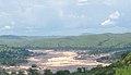
| Inga Falls |
|
25,768 (est.) | 21 | 914 | Congo | DRC | 5°26′56″S 13°35′18″E | The Inga falls, whose status as a true waterfall is controversial, are currently incorporated into the Inga I and Inga II hydroelectric facilities. The volume of the river diverted is approximately 30% of the average discharge. The Grand Inga Dam, potentially the world's largest by generating capacity, is also proposed to be built on the falls. |
| Livingstone Falls |

|
25,060 | 6 | 701 | Congo |
DRC Congo |
4°52′41″S 14°26′08″E | A set of rapids that drops 6 metres (20 ft). Located at the southern end of the Republic of the Congo's border with the Congo River. |
| Boyoma Falls |

|
16,990 | 5 | 1,372 | Lualaba, Congo | DRC | 0°29′27″N 25°12′24″E | A series of seven cataracts, also referred to as the Stanley Falls. The last and most significant of these cataracts, at Kisangani, is known as Wagenia. The Boyoma Falls marks the transition to the Congo River from the Lualaba River. |
| Khone Phapheng Falls |

|
11,610 | 21 | 10,783 | Mekong | Laos | 13°57′18″N 105°54′10″E | A series of falls and rapids that when measured end-to-end is over 10 kilometres in width, making it the world's widest waterfall. Largest waterfall in Asia by average flow rate. |
| Pará Falls |

|
3,540 | 64 | 5,608 | Caura |
Venezuela |
6°19′01″N 64°30′33″W | Largest extant waterfall in South America by average flow rate. |
| Paulo Afonso Falls |

|
2,832 | 59 | 18 | São Francisco | Brazil | 9°23′21″S 38°11′45″W | Flow regulated by the Paulo Afonso Hydroelectric Complex. |
| Niagara Falls |

|
2,407 | 51 | 1,204 | Niagara |
Canada United States |
43°04′48″N 79°04′16″W | Largest extant waterfall in North America by average flow rate. Flow regulated by the Robert Moses Niagara and Sir Adam Beck Hydroelectric Generating Stations. |
| Vermilion Falls |

|
1,812 | 5 | 1,829 | Peace | Canada | 58°22′11″N 114°52′18″W | |
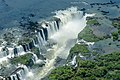
| Iguazú Falls |
|
1,746 | 64 | 2,682 | Iguazú |
Argentina Brazil |
25°41′43″S 54°26′12″W | |
| Limestone Falls |
|
1,464 | 22 | 335 | Caniapiscau | Canada | 57°28′45″N 69°18′36″W | Flow regulated by the KA-3 Dam of the Caniapiscau Reservoir. |
| Pyrite Falls |

|
1,464 | 8 | 579 | Caniapiscau | Canada | 57°26′00″N 69°14′32″W | Flow regulated by the KA-3 Dam of the Caniapiscau Reservoir. |
| Victoria Falls |

|
1,088 | 105 | 1,707 | Zambezi | ZambiaZimbabwe | 17°55′27″S 25°51′22″E | Produces the largest sheet of falling water in the world. |
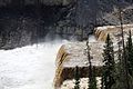
| Virginia Falls |

|
1,000 | 90 | 259 | South Nahanni | Canada | 61°36′27″N 125°44′20″W | |
| Ngonye Falls |

|
963 | 25 | ? | Zambezi | Zambia | 16°39′08″S 23°34′17″E | Also known as Sioma Falls. |
| Shale Falls |
|
934 | 18 | 610 | Caniapiscau | Canada | 56°44′39″N 69°01′04″W | Flow regulated by the KA-3 Dam of the Caniapiscau Reservoir. |
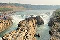
| Shivanasamudra Falls |

|
934 | 98 | 305 | Cauvery | India | 12°17′33″N 77°10′03″E | This waterfall divides around Sivasamudram Island. One side is known as Gagana chukki and the other side is known as Bara chukki. |
| Willamette Falls |

|
928 | 13 | 457 | Willamette | United States | 45°21′05″N 122°37′09″W | Prior to the development of the Oregon City area, it is thought the falls may have spanned as much as 762 metres across. Flow regulated by the T. W. Sullivan Hydroelectric Plant. |
| Kongou Falls |

|
900 | 56 | 3,200 | Ivindo | Gabon | 0°17′17″N 12°35′17″E | |
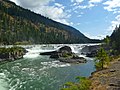
| Kootenai Falls |
|
731 | 9 | 258 | Kootenay | United States | 48°27′20″N 115°45′48″W | |
| Laksforsen |
|
700 | 17 | ? | Vefsna | Norway | 65°37′25″N 13°17′26″E | |
| Oatmeal Rapids |

|
697 | ? | ? | Rupert River | Canada | 51°21′24″N 77°25′11″E | Despite being nominally rapids, the falls are steep enough as to not meet the technical definition due to the final drop. |
| Kaieteur Falls |
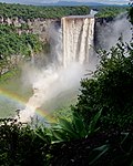
|
663 | 226 | 113 | Potaro | Guyana | 5°10′30″N 59°28′50″W | |
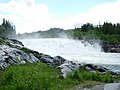
| Rheinfall |
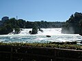
|
595 | 24 | 122 | Rhine | Switzerland | 47°40′40″N 8°36′56″E | Largest waterfall in Europe by average flow rate. |
| Sarp Falls |
|
577 | 21 | ? | Glomma | Norway | 59°16′34″N 11°07′51″E | Second-largest waterfall in Europe by average flow rate. |
| Kalandula Falls |

|
566 | 105 | 411 | Lucala | Angola | 9°04′26″S 16°00′03″E | |
| Chutes de Shawinigan |

|
513 | 50 | ? | Saint-Maurice | Canada | 46.531360°N 72.761830°W / 46.531360; -72.761830 (Shawinigan Falls) | Flow regulated by the Shawinigan 2 and Shawinigan 3 dams. |
| Chaudière Falls |

|
500 | 35 | 240 | Chaudière | Canada | 46°42′47″N 71°17′10″W | Flow regulated by the Sartigan Dam. |
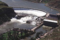
| Great Falls |

|
474 (est.) | ? | 107 | Potomac | United States | 38°59′51″N 77°15′09″W | Flow regulated by the Washington Aqueduct. |
| Kazan Falls |

|
459 | ? | ? | Kazan River | Canada | 63°42′50″N 95°50′41″W | |
| Granite Falls |
|
453 | 21 | ? | Caniapiscau | Canada | 55°50′42″N 68°25′25″W | Flow regulated by the KA-3 Dam of the Caniapiscau Reservoir. |
| Chutes de la Lobé |
|
390 | ? | ? | Lobé River | Cameroon | 2°52′56″N 9°53′49″E | |
| Hidden Falls | 425 | 30 | ? | Yarlung Tsangpo | China | 29°46′34″N 95°10′54″E | ||
| Ulaan Tsutgalan Waterfall |

|
380 | 10 | 24 | Orkhon River | Mongolia | 50°15′00″N 106°08′20″E | The flow rate heavely altered by mining operations. |
| Saint Anthony Falls |

|
370 | 15 | ? | Mississippi River | US | 44°58′54″N 93°15′31″W | Shape and flow rate severely altered by large hydroelectric developments. |
| Urriðafoss |
|
360 | 4 | 229 | Þjórsá | Iceland | 63°55′30″N 20°40′22″W | |
| Little Eaton Canyon Falls |

|
317 | Caniapiscau | Canada | 55°31′46″N 68°17′40″W | Flow regulated by the KA-3 Dam of the Caniapiscau Reservoir. | ||
| Lower Eaton Canyon Falls |

|
317 | Caniapiscau | Canada | 55°33′46″N 68°11′50″W | Flow regulated by the KA-3 Dam of the Caniapiscau Reservoir. | ||
| Nastapoca Falls |
|
317 | 35 | 35 | Nastapoca | Canada | 56°54′54″N 76°31′46″W | |
| Tuktu Falls | 317 | Caniapiscau | Canada | 55°32′36″N 68°14′44″W | Flow regulated by the KA-3 Dam of the Caniapiscau Reservoir. | |||
| Twin Falls | 317 | 48 | 61 | Nastapoca | Canada | 56°53′54″N 76°24′12″W | ||
| Upper Eaton Canyon Falls |
|
317 | Caniapiscau | Canada | 55°33′29″N 68°12′57″W | Flow regulated by the KA-3 Dam of the Caniapiscau Reservoir. | ||
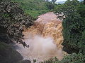
| Augrabies Falls |
|
313 | 56 | 24 | Orange | South Africa | 28°35′29″S 20°20′25″E | |
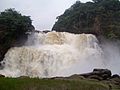
| Murchison Falls |

|
300 | 43 | 15 | White Nile | Uganda | 2°16′43″N 31°41′09″E | Flow regulated by the Karuma Hydroelectric Power Station. |
| Dhuandhar Falls |
|
294 | 30 | ? | Narmada River | India | 23°07′30″N 79°48′53″E | |
| Alexandra Falls |

|
282 | 32 | 117 | Hay River | Canada | 60°30′02″N 116°16′46″W | |
| Louise Falls |
|
282 | 15 | 183 | Hay River | Canada | 60°30′12″N 116°14′29″W | |
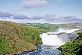
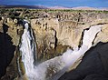
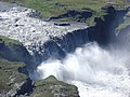
| Dettifoss |

|
269 | 51 | 171 | Jökulsá á Fjöllum | Iceland | 65°48′53″N 16°23′04″W | |
| Hafragilsfoss |
|
269 | 27 | 85 | Jökulsá á Fjöllum | Iceland | 65°49′56″N 16°23′57″W | |
| Réttarfoss |

|
269 | ? | ? | Jökulsá á Fjöllum | Iceland | 65°52′47″N 16°26′09″W | |
| Selfoss |

|
269 | 13 | 387 | Jökulsá á Fjöllum | Iceland | 65°48′18″N 16°23′12″W | |
| Kanawha Falls |
|
255 | ? | ? | Kanawha River | United States | 38.138°N 81.213°W / 38.138; -81.213 (Sandstone Falls) | |
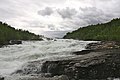
| Ristafallet |

|
250 | 14 | 50 | Indalsälven | Sweden | 63.31256°N 13.350903°E / 63.31256; 13.350903 (Ristafallet) | |
| Sandstone Falls |
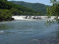
|
222 | 4 | 549 | New River | United States | 37°45′24″N 80°54′21″W | |
| Huka Falls |

|
220 | 11 | ? | Waikato River | New Zealand | 38°38′55″S 176°05′24″E | |
| Félou Falls |

|
216 | 13 | ? | Senegal River | Mali | 14°21′13″S 11°20′43″W | Flow regulated by the Félou Hydroelectric Plant. |
| Gouina Falls |

|
216 | 16 | 500 | Senegal River | Mali | 14°00′54″S 11°06′09″W | Flow regulated by the Gouina Hydroelectric Plant. |
| Big Falls |
|
213 | 27 | 183 | Missouri River | United States | 47°34′08″N 111°07′26″W | Flow regulated by the Ryan Dam. |
| Black Eagle Falls |

|
213 | 8 | 183 | Missouri River | United States | 47°31′11″N 111°15′44″W | Flow regulated by the Black Eagle Dam. |
| Crooked Falls | 213 | 6 | 457 | Missouri River | United States | 47°32′06″N 111°11′47″W | Flow regulated by the Rainbow Dam. | |
| Rainbow Falls |

|
213 | 13 | 305 | Missouri River | United States | 47°32′00″N 111°12′19″W | Flow regulated by the Rainbow Dam. |
| Rusumo Falls |
|
210 | 15 | 40 | Kagera River | Rwanda Tanzania | 2°22′57″S 30°47′00″W | |
| Målselvfossen |
|
196 | 22 | 600 | Målselva | Norway | 69°02′09″N 18°39′16″E | |
| Storforsen |
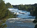
|
187 | 35 | 76 | Pite River | Sweden | 65°50′59″N 20°24′16″E | |
| Kabwelume Falls |

|
181 | ? | ? | Kalungwishi River | Zambia | 9°31′29″S 29°21′05″E | |
| Lumangwe Falls |

|
181 | ? | ? | Kalungwishi River | Zambia | 9°32′32″S 29°23′11″E | |
| Zongo Falls |
|
179 | ? | ? | Inkisi River | DRC | 4.777431°S 14.905735°E / -4.777431; 14.905735 (Zongo Falls) | Flow regulated by the Zongo II Hydroelectric Power Station. |
| Rearguard Falls |

|
171 | 6 | 61 | Fraser River | Canada | 52°58′24″N 119°21′51″W | |
| Cohoes Falls |

|
161 | 20 | 290 | Mohawk River | United States | 42°47′17″N 73°42′31″W | Flow regulated by the School Street Hydroelectric Generating Facility. |
| Epupa Falls |

|
160 | 37 | 1500 | Cunene River | Angola Namibia | 17°00′00″S 13°14′36″E | Flow regulated by the Ruacana Hydroelectric Power Station. |
| Ruacana Falls |

|
160 | 120 | 700 | Cunene River | Angola Namibia | 17°23′38″S 14°13′04″E | Flow regulated by the Ruacana Hydroelectric Power Station. |
| Jog Falls |

|
153 | 253 | 472 | Sharavati River | India | 14°13′45″N 74°48′45″E | Flow regulated by the Linganamakki Dam. |
Largest historic waterfalls
This list comprises the waterfalls which have ceased to exist due to the impoundment of their river(s) by a dam, or due to the diversion of the watercourse.
| Waterfall | Image | Flow rate (m3/s) | Drop (m) | Width (m) | River | Countries | Coordinates | Notes |
|---|---|---|---|---|---|---|---|---|
| Guaíra Falls |

|
13,309 | 40 | 4,828 | Paraná |
Brazil Paraguay |
24°04′03″S 54°17′00″W | Submerged beneath the Itaipu Reservoir following the completion of the Itaipu Dam in 1982. |
| Celilo Falls |

|
5,366 | 6.1 | 1,768 | Columbia | United States | 45°39′05″N 120°58′10″W | Submerged beneath the Columbia River following the completion of The Dalles Dam in 1957. The rock formation responsible for the falls remains intact. |
| Kettle Falls |

|
4,682 | ? | ? | Columbia | United States | 48°37′52″N 118°07′08″W | Submerged beneath Lake Roosevelt following the completion of the Grand Coulee Dam in 1940. The formation responsible for the falls remains intact. |
| Urubupunga Falls | 2,747 | 13 | 2,012 | Paraná | Brazil | 20°36′S 51°33′W | Submerged beneath the Paraná River following completion of the Engineer Souza Dias Dam in 1982. The formation responsible for the falls remains intact. | |
| Marimbondo Falls | 1,501 | 24 | 2,012 | Rio Grande | Brazil | 20°18′35″S 49°12′06″W | The Marimbondo Dam was built atop the upper portion of the falls in 1971. The section further upstream was submerged beneath the Rio Grande, while the section below the dam was dewatered and are visible. | |
| San Rafael Falls |

|
400 | 94 | 23 | Coca | Ecuador | 0°06′15″S 77°34′51″W | On 2 February 2020, a large sinkhole formed just above the falls, diverting its flow beneath a large band of rock (the former brink of the falls) which survived the collapse and became a natural bridge until it too collapsed. Although the river initially still fell over 100 m (330 ft) into the sinkhole, very rapid headward erosion has since left no significant waterfall at this location. |
| La Chute Grande | 170 | 19 | ? | Romaine | Canada | 50°23′14″S 63°15′06″W | Destroyed by the construction of the Romaine-1 Generating Station at the top of the falls. |
Prehistoric waterfalls
| Waterfall | Maximum daily flow rate (m3/s) | Tallest single drop (m) | Width (m) | River | Countries |
|---|---|---|---|---|---|
| Gibraltar (Zanclean deluge hypothesis) | 100,000,000 | Strait of Gibraltar |
Spain Morocco |
||
| Dry Falls | 1,906,000 | 120 | 4,828 | Columbia | United States |
| Bosphorus (Black Sea deluge hypothesis) | 480,000 | 80 | Bosphorus Strait | Turkey |