List of Torres Strait Islands
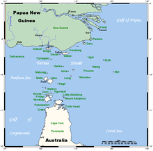
The Torres Strait Islands are a group of at least 274 small islands in the Torres Strait between Queensland, Australia and Papua New Guinea.
This is a list of the named islands and island groups in the Torres Strait. In addition there are unnamed islands and named and unnamed rocks.
Almost all of the islands in the Torres Strait are part of Australia; consequently all entries in this table are in Australia unless noted as being in Papua New Guinea.
Table of islands
| Name | Other names | Position | Group | Population | Area (km²) | Freehold? | Notes |
|---|---|---|---|---|---|---|---|
| Aipus Island | 9.941°S 142.172°E / -9.941; 142.172 (Aipus Island) | Belle Vue Islands | |||||
| Akone Islet | 10.66730112°S 142.6700377°E / -10.66730112; 142.6700377 (Akone Islet) | ||||||
| Albany Island | 10.72981076°S 142.6053586°E / -10.72981076; 142.6053586 (Albany Island) | ||||||
| Allison Islet | Nur Islet | 10.100278°S 142.08139°E / -10.100278; 142.08139 (Allison Islet) | |||||
| Anchor Cay | 9.36194°S 144.09889°E / -9.36194; 144.09889 (Anchor Cay) | ||||||
| Arden Island | Garboy Island | 9.868334°S 143.171112°E / -9.868334; 143.171112 (Arden Island) | Belle Vue Islands | ||||
| Aubussi Island | 9.23389°S 142.169724°E / -9.23389; 142.169724 (Aubussi Island) | Talbot Islands | |||||
| Aukane Islet | 9.868055°S 143.393616°E / -9.868055; 143.393616 (Aukane Islet) | Bourke Isles | |||||
| Aureed Island | 9.953611°S 143.289734°E / -9.953611; 143.289734 (Aureed Island) | Bourke Isles | |||||
| Badu Island | Mulgrave Island | 10.115556°S 142.144714°E / -10.115556; 142.144714 (Badu Island) | 690 | 97.8 | |||
| Barn Island | Parau Island | 10.839058°S 142.318069°E / -10.839058; 142.318069 (Barn Island) | |||||
| Barney Island | Tuin | 10.218888°S 142.166382°E / -10.218888; 142.166382 (BarneyIsland) | |||||
| Belle Vue Islands | 9.934444°S 142.161377°E / -9.934444; 142.161377 (Belle Vue Islands) | ||||||
| Bet Islet | Burrar Islet | 10.145833°S 142.819443°E / -10.145833; 142.819443 (Bet Islet) | The Three Sisters | 0 | 0.2 | ||
| Boigu Island | 9.260278°S 142.213608°E / -9.260278; 142.213608 (Boigu Island) | Talbot Islands | 270 | 72.2 | |||
| Bond Island | 10.073509°S 142.26445°E / -10.073509; 142.26445 (Bond Island) | ||||||
| Booby Island | 10.604167°S 141.910828°E / -10.604167; 141.910828 (Booby Island) | ||||||
| Bourke Island | 9.883234°S 143.484436°E / -9.883234; 143.484436 (Bourke Island) | ||||||
| Bourke Isles | 9.84417°S 143.40222°E / -9.84417; 143.40222 (Bourke Isles) | ||||||
| Bramble Cay | 9.1425°S 143.87611°E / -9.1425; 143.87611 (Bramble Cay) | ||||||
| Brewis Island | 10.8875°S 142.69417°E / -10.8875; 142.69417 (Brewis Island) | ||||||
| Browne Island | Ngul | 10.223611°S 142.153885°E / -10.223611; 142.153885 (Browne Island) | |||||
| Bush Islet | 10.70888085°S 142.5978684°E / -10.70888085; 142.5978684 (Bush Islet) | ||||||
| Campbell Island | Tappoear Island | 9.56018°S 143.492767°E / -9.56018; 143.492767 (Campbell Island) | |||||
| Canoe Cay | 9.70028°S 143.83361°E / -9.70028; 143.83361 (Canoe Cay) | ||||||
| Canoe Island | Dadali | 10.343888°S 142.108612°E / -10.343888; 142.108612 (Canoe Island) | |||||
| Cap Islet | Muquar Island | 9.836007°S 142.714996°E / -9.836007; 142.714996 (Cap Islet) | Belle Vue Islands | ||||
| Castle Island | Bakilai | 10.047123°S 142.157776°E / -10.047123; 142.157776 (Castle Island) | |||||
| Channel Island | 10.35184°S 142.228058°E / -10.35184; 142.228058 (Channel Island) | ||||||
| Cheropo Island | 10.68898058°S 142.2808592°E / -10.68898058; 142.2808592 (Cheropo Island) | ||||||
| Clarke Island | Tukupai | 10.207953°S 142.145828°E / -10.207953; 142.145828 (Clarke Island) | |||||
| Coconut Island | Poruma Island, Parremar Island, Cocoa Nut Island |
10.048612°S 143.06778°E / -10.048612; 143.06778 (Coconut Island) | 180 | 0.54 | |||
| Crab Island | Moent | 10.973055°S 142.105835°E / -10.973055; 142.105835 (Crab Island) | |||||
| Dalrymple Islet | Damuth Island | 9.609445°S 143.303055°E / -9.609445; 143.303055 (Dalrymple Islet) | |||||
| Darnley Island | Erub Island | 9.586945°S 143.770554°E / -9.586945; 143.770554 (Darnley Island) | 316 | 5.5 | |||
| Daua Island | Dowar Island, Dauar | 9.94389°S 144.02583°E / -9.94389; 144.02583 (Daua Island) | 0.37 | ||||
| Dauan Island | Cornwallis Island | 9.42323389°S 142.5361169°E / -9.42323389; 142.5361169 (Dauan Island) | Murray Islands | 120 | 4 | ||
| Dayman Island | Teran | 10.76159026°S 142.3736798°E / -10.76159026; 142.3736798 (Dayman Island) | |||||
| Deliverance Island | Warul Kawa | 9.516854°S 141.571945°E / -9.516854; 141.571945 (Deliverance Island) | |||||
| Dove Islet | 9.996389°S 143.029434°E / -9.996389; 143.029434 (Dove Islet) | ||||||
| Dugong Islet | 10.52004517°S 143.1001704°E / -10.52004517; 143.1001704 (Dugong Islet) | ||||||
| Dumaralug Island | 10.764059°S 142.213074°E / -10.764059; 142.213074 (Dumaralug Island) | ||||||
| Duncan Islands | 10.236667°S 142.079437°E / -10.236667; 142.079437 (Duncan Islands) | ||||||
| East Cay | 9.39194°S 144.21778°E / -9.39194; 144.21778 (East Cay) | ||||||
| East Strait Island | 10.49564064°S 142.4504092°E / -10.49564064; 142.4504092 (East Strait Island) | ||||||
| Eborac Island | 10.68235038°S 142.5341391°E / -10.68235038; 142.5341391 (Eborac Island) | ||||||
| Entrance Island | Zuna Island | 10.718225°S 142.295853°E / -10.718225; 142.295853 (Entrance Island) | |||||
| 10.042778°S 142.06778°E / -10.042778; 142.06778 (Farewell Islets) | Farewell Islets | ||||||
| Flat Islet | 10.11806°S 142.07472°E / -10.11806; 142.07472 (Flat Islet) | ||||||
| Florence Island | Talab | 9.956289°S 142.210831°E / -9.956289; 142.210831 (Florence Island) | Belle Vue Islands | ||||
| Friday Island | Gealug Island | 10.596837°S 142.165283°E / -10.596837; 142.165283 (Friday Island) | 20 | 4.8 | |||
| Gabba Island | Gerbar Island | 9.765174°S 142.633331°E / -9.765174; 142.633331 (Gabba Island) | |||||
| Gainaulai Islet | 10.31684208°S 142.0927734°E / -10.31684208; 142.0927734 (Gainaulai Islet) | ||||||
| Getullai Island | 10.189722°S 142.514999°E / -10.189722; 142.514999 (Getullai Island) | ||||||
| Goods Island | Palilug | 10.562672°S 142.159729°E / -10.562672; 142.159729 (Goods Island) | |||||
| Great Woody Island | Kai Yalubi Island | 10.7040408°S 142.3526891°E / -10.7040408; 142.3526891 (Great Woody Island) | |||||
| Green Islet | Ilapnab | 10.191112°S 142.117783°E / -10.191112; 142.117783 (Green Islet) | |||||
| Half Way Island | 10.105556°S 143.320282°E / -10.105556; 143.320282 (Half Way Island) | ||||||
| Hammond Island | Keriri Island | 10.54572715°S 142.2141809°E / -10.54572715; 142.2141809 (Hammond Island) | 204 | 14.5 | |||
| Hawkesbury Island | Warral Island | 10.37103572°S 142.1315632°E / -10.37103572; 142.1315632 (Hawkesbury Island) | |||||
| High Island | Wurrka | 10.725169°S 142.414185°E / -10.725169; 142.414185 (High Island) | |||||
| High Island | Wia | 10.200277°S 142.1689°E / -10.200277; 142.1689 (High Island) | |||||
| Horn Island | Narupai | 10.607114°S 142.28418°E / -10.607114; 142.28418 (Horn Island) | 650 | 53.8 | |||
| Iadi Island | 9.931012154°S 142.1577759°E / -9.931012154; 142.1577759 (Iadi Island) | Belle Vue Islands | |||||
| Ida Island | 10.70964062°S 142.5579888°E / -10.70964062; 142.5579888 (Ida Island) | ||||||
| Johnson Islet | 10.65787222°S 142.7542657°E / -10.65787222; 142.7542657 (Johnson Islet) | ||||||
| Kabbikane Islet | 9.819346°S 143.40831°E / -9.819346; 143.40831 (Kabbikane Islet) | Bourke Isles | |||||
| Kamutnab Islet | 9.961666°S 142.152222°E / -9.961666; 142.152222 (Kamutnab Islet) | Belle Vue Islands | |||||
| Kanig Island | 10.24239826°S 142.0827789°E / -10.24239826; 142.0827789 (Kanig Island) | Duncan Islands | |||||
| Kapuda Islet | 10.564893°S 142.224731°E / -10.564893; 142.224731 (Kapuda Islet) | ||||||
| Karniga Island | 10.76732017°S 142.38718°E / -10.76732017; 142.38718 (Karniga Island) | ||||||
| Kaub Islets | 9.960555077°S 142.210556°E / -9.960555077; 142.210556 (Kaub Islets) | Belle Vue Islands | |||||
| Kaumag Island | 9.367678°S 142.696121°E / -9.367678; 142.696121 (Kaumag Island) | ||||||
| Keatinge Islet | 10.62694°S 142.66333°E / -10.62694; 142.66333 (Keatinge Islet) | ||||||
| Keats Island | Homogar Islet ?, Umaga Parish | 9.684167°S 143.430283°E / -9.684167; 143.430283 (Keats Island) | Yorke Islands | ||||
| Kerr Islet | 9.60889°S 141.568893°E / -9.60889; 141.568893 (Kerr Islet) | ||||||
| Kodall Island | 9.740001°S 143.446945°E / -9.740001; 143.446945 (Kodall Island) | Yorke Islands | |||||
| Kongan Rock | 9.945178986°S 142.1738892°E / -9.945178986; 142.1738892 (Kongan Rock) | Belle Vue Islands | |||||
| Kunai Islet | 10.583055°S 142.176392°E / -10.583055; 142.176392 (Kunai Islet) | ||||||
| Lacey Island | 10.611667°S 142.610001°E / -10.611667; 142.610001 (Lacey Island) | ||||||
| Layoak Islet | 9.862223°S 143.308334°E / -9.862223; 143.308334 (Layoak Islet) | Bourke Isles | |||||
| Little Adolphus Island | 10.59412085°S 142.6157781°E / -10.59412085; 142.6157781 (Little Adolphus Island) | ||||||
| Little Ida Island | 10.72055531°S 142.5572205°E / -10.72055531; 142.5572205 (Little Ida Island) | ||||||
| Little Roko Island | 10.73593028°S 142.4191598°E / -10.73593028; 142.4191598 (Little Roko Island) | ||||||
| Little Woody Island | Meggi Yalubi Island | 10.71531069°S 142.3442993°E / -10.71531069; 142.3442993 (Little Woody Island) | |||||
| Lowry Islet | 10.101111°S 142.818054°E / -10.101111; 142.818054 (Lowry Islet) | ||||||
| Mabuiag Island | Jervis Island | 9.954344918°S 142.1808474°E / -9.954344918; 142.1808474 (Mabuiag Island) | Belle Vue Islands | 50 | 7.5 | ||
| Mai Islet | 10.72151094°S 142.6248383°E / -10.72151094; 142.6248383 (Mai Islet) | ||||||
| Markilug Islet | Markailag | 10.77378°S 142.393356°E / -10.77378; 142.393356 (Markilug Islet) | |||||
| Marsden Islet | Eegarbu | 9.711111°S 143.362228°E / -9.711111; 143.362228 (Marsden Islet) | Yorke Islands | ||||
| Marte Island | 9.934345245°S 142.1636047°E / -9.934345245; 142.1636047 (Marte Island) | Belle Vue Islands | |||||
| Masig Island | 9.749445°S 143.407501°E / -9.749445; 143.407501 (Masig Island) | Yorke Islands | |||||
| Meddler Island | Gaibait | 10.702°S 142.383°E / -10.702; 142.383 (Meddler Island) | |||||
| Meer Island |
Maer Island, Mer Island, Murray Island | 9.917°S 144.050°E / -9.917; 144.050 (Meer Island) | Murray Islands | 485 | 4.29 | ||
| Meth Islet | 10.223°S 142.067°E / -10.223; 142.067 (Meth Islet) | Duncan Islands | |||||
| Middle Brother | 10.712°S 142.681°E / -10.712; 142.681 (Middle Brother) | ||||||
| Mimi Islet | 9.950°S 143.400°E / -9.950; 143.400 (Mimi Islet) | Bourke Isles | |||||
| Mipa Islet | 9.960456848°S 142.1711121°E / -9.960456848; 142.1711121 (Mipa Islet) | Belle Vue Islands | |||||
| Moa Island | Banks Island | 10.183°S 142.267°E / -10.183; 142.267 (Moa Island) | 394 | 171.7 | |||
| Moimi Island | 9.233°S 142.250°E / -9.233; 142.250 (Moimi Island) | Talbot Islands | |||||
| Morilug Islet | 10.822°S 142.6832°E / -10.822; 142.6832 (Morilug Islet) | ||||||
| Mouinndo Islet | 10.828°S 142.366°E / -10.828; 142.366 (Mouinndo Islet) | ||||||
| Mount Adolphus Island | Mori | 10.673°S 142.652°E / -10.673; 142.652 (Mount Adolphus Island) | |||||
| Mount Ernest Island | Nagheer Island | 10.250°S 142.483°E / -10.250; 142.483 (Mount Ernest Island) | |||||
| Murangi Islet | 10.695°S 142.493°E / -10.695; 142.493 (Murangi Islet) | ||||||
| Murray Islands | |||||||
| Nepean Island | Attagoy Island | 9.567°S 143.650°E / -9.567; 143.650 (Nepean Island) | |||||
| Nicklin Islet | 10.671°S 142.650°E / -10.671; 142.650 (Nicklin Islet) | ||||||
| North Brother | 10.704336°S 142.670013°E / -10.704336; 142.670013 (North Brother) | ||||||
| North Island | 9.950°S 142.200°E / -9.950; 142.200 (North Island) | ||||||
| North Island | 10.028234°S 142.128891°E / -10.028234; 142.128891 (North Island) | ||||||
| North Possession Island | Iem Island | 10.082°S 142.327°E / -10.082; 142.327 (North Possession Island) | |||||
| North West Islet | 10.667°S 142.100°E / -10.667; 142.100 (North West Islet) | ||||||
| Obelisk Islet | 10.100°S 142.100°E / -10.100; 142.100 (Obelisk Islet) | ||||||
| Packe Island | Tarilag Island | 10.743°S 142.223°E / -10.743; 142.223 (Packe Island) | Thursday Islands | 10 | 0.7 | ||
| Parama Island | Bampton (former) | 9.00250°S 143.41528°E / -9.00250; 143.41528 (Parama Island) | Papua New Guinea | ||||
| Passage Island | Bupu | 9.977°S 142.2393°E / -9.977; 142.2393 (Passage Island) | Belle Vue Islands | ||||
| Pearce Cay | Mallicamas | 9.500°S 143.283°E / -9.500; 143.283 (Pearce Cay) | |||||
| Pelican Islet | 9.968054771°S 142.2158356°E / -9.968054771; 142.2158356 (Pelican Islet) | Belle Vue Islands | |||||
| Phipps Island | Zurat | 10.277°S 142.102°E / -10.277; 142.102 (Phipps Island) | |||||
| Pita Dabai Island | 10.19083309°S 142.1741791°E / -10.19083309; 142.1741791 (Pita Dabai Island) | ||||||
| Poll Islet | Guijar Islet | 10.200°S 142.833°E / -10.200; 142.833 (Poll Islet) | The Three Sisters | ||||
| Port Lihou Island | Yeta | 10.43°S 142.14°E / -10.43; 142.14 (Port Lihou Island) | Inner islands | ||||
| Portlock Island | Kulbi | 10.117°S 142.359°E / -10.117; 142.359 (Portlock Island) | |||||
| Possession Island | Tuined, Bedanug | 10.725447°S 142.398071°E / -10.725447; 142.398071 (Possession Island) | |||||
| Prince of Wales Island | Muralag Island | 10.684°S 142.185°E / -10.684; 142.185 (Prince of Wales Island) | 20 | 204.6 | |||
| Puigulag Islet | 9.96583271°S 142.2138824°E / -9.96583271; 142.2138824 (Puigulag Islet) | Belle Vue Islands | |||||
| Pulu Islet | 9.957°S 142.163°E / -9.957; 142.163 (Pulu Islet) | Belle Vue Islands | |||||
| Pumpkin Island | Ngurthai | 10.02083302°S 142.1208344°E / -10.02083302; 142.1208344 (Pumpkin Island) | |||||
| Pururai Islet | 9.941667°S 142.179443°E / -9.941667; 142.179443 (Pururai Islet) | Belle Vue Islands | |||||
| Quoin Island | 10.713°S 142.370°E / -10.713; 142.370 (Quoin Island) | Yes | |||||
| Red Fruit Islet | 9.936666°S 142.178345°E / -9.936666; 142.178345 (Red Fruit Islet) | Belle Vue Islands | |||||
| Red Island | 10.884°S 142.359°E / -10.884; 142.359 (Red Island) | ||||||
| Red Wallis Island | 10.849°S 142.026°E / -10.849; 142.026 (Red Wallis Island) | ||||||
| Rennel Island | Mauar | 9.767°S 143.267°E / -9.767; 143.267 (Rennel Island) | Yorke Islands | ||||
| Roberts Islet | 9.967°S 143.117°E / -9.967; 143.117 (Roberts Islet) | Bourke Isles | |||||
| Roko Island | 10.741°S 142.410°E / -10.741; 142.410 (Roko Island) | ||||||
| Round Island | 10.07444°S 142.09583°E / -10.07444; 142.09583 (Round Island) | ||||||
| Round Island | 10.54143164°S 142.1911879°E / -10.54143164; 142.1911879 (Round Island) | ||||||
| Saddle Island | 10.167°S 142.683°E / -10.167; 142.683 (Saddle Island) | ||||||
| Saibai Island | 9.390°S 142.620°E / -9.390; 142.620 (Saibai Island) | 317 | 107.9 | ||||
| Salter Island | 10.598°S 142.637°E / -10.598; 142.637 (Salter Island) | ||||||
| Sassie Island | 10.033°S 142.850°E / -10.033; 142.850 (Sassie Island) | ||||||
| Scott Island | 9.9625°S 142.209991°E / -9.9625; 142.209991 (Scott Island) | Belle Vue Islands | |||||
| Smith Cay | 9.750°S 143.333°E / -9.750; 143.333 (Smith Cay) | Yorke Islands | |||||
| South Brother | 10.718781°S 142.688339°E / -10.718781; 142.688339 (South Brother) | ||||||
| South Island | Aia | 10.045456°S 142.131668°E / -10.045456; 142.131668 (South Island) | |||||
| Spencer Island | Kulbai Kulbai | 10.290°S 142.101°E / -10.290; 142.101 (Spencer Island) | |||||
| Stephens Island | Hogar, Ugar Island | 9.507°S 143.545°E / -9.507; 143.545 (Stephens Island) | 100 | 0.35 | |||
| Stonehenge | Gainaulai Islet | 10.316944°S 142.092773°E / -10.316944; 142.092773 (Stonehenge) | |||||
| Suarji Island | 10.167°S 142.517°E / -10.167; 142.517 (Suarji Island) | ||||||
| Subur Islet | 9.972°S 142.217°E / -9.972; 142.217 (Subur Islet) | Belle Vue Islands | |||||
| Sue Islet | Warraber Islet | 10.207°S 142.825°E / -10.207; 142.825 (Sue Islet) | The Three Sisters | 216 | 0.8 | ||
| Tern Island | 10.998334°S 142.758896°E / -10.998334; 142.758896 (Tern Island) | ||||||
| Tetley Island | 10.7264217°S 142.7283669°E / -10.7264217; 142.7283669 (Tetley Island) | ||||||
| The Three Sisters | 10.197223°S 142.825562°E / -10.197223; 142.825562 (The Three Sisters) | ||||||
| Three Month Island | 10.18388939°S 142.1688995°E / -10.18388939; 142.1688995 (Three Month Island) | ||||||
| Thursday Island | Wai-Ben, Waiben | 10.579°S 142.220°E / -10.579; 142.220 (Thursday Island) | 2,682 | 3.5 | |||
| Tik Island | 10.17750072°S 142.1761169°E / -10.17750072; 142.1761169 (Tik Island) | ||||||
| Tobin Cay | 9.612778°S 143.661377°E / -9.612778; 143.661377 (Tobin Cay) | ||||||
| Tobin Island | Zagarsum | 10.105278°S 142.344437°E / -10.105278; 142.344437 (Tobin Island) | |||||
| Travers Island | Warral Island | 10.368°S 142.363°E / -10.368; 142.363 (Travers Island) | |||||
| Tree Island | 10.071111°S 142.069717°E / -10.071111; 142.069717 (Tree Island) | ||||||
| Tree Island | Iul Island | 10.704°S 142.597°E / -10.704; 142.597 (Tree Island) | |||||
| Trochus Island | 10.92199019°S 142.6302797°E / -10.92199019; 142.6302797 (Trochus Island) | ||||||
| Tudu Island | Warrior Island | 9.800°S 142.967°E / -9.800; 142.967 (Tudu Island) | |||||
| Tuesday Islets | 10.55174248°S 142.3456073°E / -10.55174248; 142.3456073 (Tuesday Islets) | ||||||
| Tuluaa Islet | 10.84385983°S 142.3489806°E / -10.84385983; 142.3489806 (Tuluaa Islet) | ||||||
| Turnagain Island | Buru Island | 9.567°S 142.283°E / -9.567; 142.283 (Turnagain Island) | |||||
| Turtle Head Island | 10.930°S 142.680°E / -10.930; 142.680 (Turtle Head Island) | ||||||
| Turtle Island | 10.889°S 142.696°E / -10.889; 142.696 (Turtle Island) | Yes | |||||
| Turtle Island | #35422 | 10.73622002°S 142.2556798°E / -10.73622002; 142.2556798 (Turtle Island) | |||||
| Turu Cay | 9.817°S 141.417°E / -9.817; 141.417 (Turu Cay) | ||||||
| Twin Island | Nelgee Island | 10°27′46″S 142°26′32″E | |||||
| Underdown Islet | 9.483°S 143.867°E / -9.483; 143.867 (Underdown Islet) | ||||||
| Wai-Weer Islet | 10.571111°S 142.177231°E / -10.571111; 142.177231 (Wai-Weer Islet) | ||||||
| Warakuikul Talab Island | Middle Island | 9.950°S 142.221°E / -9.950; 142.221 (Warakuikul Talab Island) | Belle Vue Islands | ||||
| Wassel Island | 10.74806°S 142.40583°E / -10.74806; 142.40583 (Wassel Island) | ||||||
| Watson Cay | 10.040833°S 142.452225°E / -10.040833; 142.452225 (Watson Cay) | ||||||
| Waua Islet | Wyer Island, Waier Island | 9.48°S 144.037°E / -9.48; 144.037 (Waua Islet) | Murray Islands | 0.22 | |||
| Wednesday Island | Maururra | 10.527°S 142.307°E / -10.527; 142.307 (Wednesday Island) | |||||
| West Island | Ului | 10.360°S 142.053°E / -10.360; 142.053 (West Island) | |||||
| Whale Island | Matu | 10.246°S 142.071°E / -10.246; 142.071 (Whale Island) | |||||
| Widul Island | 9.945°S 142.160°E / -9.945; 142.160 (Widul Island) | Belle Vue Islands | |||||
| Wilson Island | Maitak | 10.233°S 142.083°E / -10.233; 142.083 (Wilson Island) | Duncan Islands | ||||
| Womer Cay | 10.793889°S 142.976654°E / -10.793889; 142.976654 (Womer Cay) | ||||||
| Woody Wallis Island | 10.882°S 142.035°E / -10.882; 142.035 (Woody Wallis Island) | ||||||
| Wuwurrka Islet | 10.76100234°S 142.3941732°E / -10.76100234; 142.3941732 (Wuwurrka Islet) | ||||||
| Yam Island | Iama, Turtle Backed Island | 9.900°S 142.767°E / -9.900; 142.767 (Yam Island) | Bourke Isles | 338 | 2.6 | ||
| Yargas Island | 10.18277836°S 142.1730652°E / -10.18277836; 142.1730652 (Yargas Island) | ||||||
| York Island | 10.684°S 142.529°E / -10.684; 142.529 (York Island) | ||||||
| Yorke Island | Masig Island | 9.745°S 143.434°E / -9.745; 143.434 (Yorke Island) | 100 | 2 | |||
| Yorke Islands | |||||||
| Zagai Island | Dungeness Island | 9.850°S 142.917°E / -9.850; 142.917 (Zagai Island) |