Kinkasan
Native name:
Japanese: 金華山
| |
|---|---|
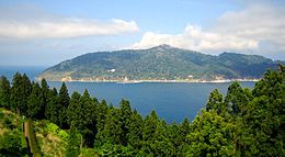 View from Oshika Peninsula
| |
| Geography | |
| Location | Pacific Ocean |
| Coordinates | 38°17′43″N 141°34′00″E |
| Archipelago | Oshika |
| Area | 10.28 km2 (3.97 sq mi) |
| Coastline | 25 km (15.5 mi) |
| Highest elevation | 445 m (1460 ft) |
| Highest point | Kinkasan |
| Administration | |
Japan | |
| Prefecture | Miyagi |
| City | Ishinomaki |
| Demographics | |
| Population | 6 (2004) |
| Ethnic groups | Japanese |

Kinkasan (金華山, Kinkasan, or Kinkazan), is a small island in Miyagi Prefecture in north-eastern Japan. It lies in the Pacific Ocean approximately one kilometer off the Oshika Peninsula.
Geography
Kinkasan is 9.5 km2 (3.7 sq mi) in area, and its highest point is the pyramid-shaped Mount Kinka, which stands at 445 m (1,460 ft).
It can be reached by ferry from Ishinomaki.
History
There is a shrine on the island, called Koganeyama-jinja, which dates from the 8th century.