Kakinada Port
| Kakinada Port | |
|---|---|
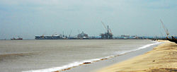 View of Kakinada port from the Beach
| |
|
Click on the map for a fullscreen view
| |
| Location | |
| Country | India |
| Location | Andhra Pradesh |
| Coordinates | 16°58′30″N 82°16′44″E |
| Details | |
| Opened | 1st April 1999 |
| No. of berths | 4 + 2 (under construction) |
| Statistics | |
| Annual cargo tonnage | 14.50 million tonnes(2016-17) |
|
Website www.kakinadaseaports.in | |
Kakinada Port is located at Kakinada off the east coast of India. It is 170 km (106 mi) south of Visakhapatnam Port.
Kakinada Port is a large complex comprising Kakinada Anchorage Port, Kakinada Deep Water Port, Kakinada Fishing Harbour and Ship-Breaking Unit. Kakinada Anchorage Port has a century-long tradition.
Kakinada Deep Water Port is an all-weather deep water port, and the channel has a depth of 12 metres (39 ft). The port can handle vessels up to 50,000 DWT. The port handled 10.81 million tonnes of cargo in 2010–2011. The AP Govt developed Kakinada beach in 2013 and it has 100 acres of land covered from port to uppada area.
Kakinada Port railway station was opened in 2011.
A new port named, Kakinada Gateway port is underconstruction in Kakinada district, This will be the third port in Kakinada district, with a proposed cargo handling capacity of 16 million tonnes of cargo.