Käerjeng
Käerjeng | |
|---|---|
 Bascharage
| |
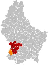 Map of Luxembourg with Käerjeng highlighted in orange, and the canton in dark red
| |
| Coordinates: 49.5836°N 5.9°E / 49.5836; 5.9 | |
| Country | Luxembourg |
| Canton | Capellen |
| Area | |
| • Total | 33.67 km2 (13.00 sq mi) |
| • Rank | 19th of 102 |
| Highest elevation | 395 m (1,296 ft) |
| • Rank | 55th of 102 |
| Lowest elevation | 271 m (889 ft) |
| • Rank | 73rd of 102 |
| Population
(2023)
| |
| • Total | 11,015 |
| • Rank | 10th of 102 |
| • Density | 330/km2 (850/sq mi) |
| • Rank | 24th of 102 |
| Time zone | UTC+1 (CET) |
| • Summer (DST) | UTC+2 (CEST) |
| LAU 2 | LU0000104 |
| Website | www |
Käerjeng (Luxembourgish pronunciation: [ˈkɛːɐ̯ʒeŋ]) is a commune in southwestern Luxembourg, in the canton of Capellen. It lies on the border with Belgium. It has an area of 33.67 km2.
The commune of Käerjeng was formed on 1 January 2012 from the former communes of Bascharage and Clemency. The law creating Käerjeng was passed on 24 May 2011.
With a population of approximately 10,000 citizens, Käerjeng is the 10th most-populous commune in Luxembourg.
Geography
Käerjeng is located on the dividing line of the waters of the Rhine basin (Eisch) and the watershed of the Meuse (Chiers). It is bordered by the communes of Pétange, Differdange, Sanem, Dippach, Garnich and Steinfort, as well as the Belgian border to the north-west.
Elevation: Between 247 m (810 ft) at Tapp near Linger and 362 m (1,188 ft) at Kues near Fingig.
Total area: 52.2 km2 (20.15 sq mi)
Climate
Käerjeng has a oceanic climate (Köppen Cfb). The annual average temperature is 9.9 °C (49.8 °F), the hottest month in July is 18.7 °C (65.7 °F), and the coldest month is 1.8 °C (35.2 °F) in January. The annual precipitation is 944.2 millimetres (37.17 in), of which December is the wettest with 121.0 millimetres (4.76 in), while April is the driest with only 53.8 millimetres (2.12 in). The extreme temperature throughout the year ranged from −19.1 °C (−2.4 °F) on December 24, 2001 to 38.6 °C (101.5 °F) on July 25, 2019.
| Climate data for Käerjeng (Clemency), 1991-2020 normals | |||||||||||||
|---|---|---|---|---|---|---|---|---|---|---|---|---|---|
| Month | Jan | Feb | Mar | Apr | May | Jun | Jul | Aug | Sep | Oct | Nov | Dec | Year |
| Record high °C (°F) | 14.4 (57.9) |
21.5 (70.7) |
21.8 (71.2) |
24.2 (75.6) |
32.2 (90.0) |
34.7 (94.5) |
38.6 (101.5) |
37.8 (100.0) |
34.3 (93.7) |
26.7 (80.1) |
19.0 (66.2) |
15.4 (59.7) |
38.6 (101.5) |
| Mean daily maximum °C (°F) | 4.1 (39.4) |
5.6 (42.1) |
10.1 (50.2) |
14.7 (58.5) |
18.7 (65.7) |
21.9 (71.4) |
24.0 (75.2) |
23.7 (74.7) |
19.4 (66.9) |
13.9 (57.0) |
8.1 (46.6) |
4.9 (40.8) |
14.1 (57.4) |
| Daily mean °C (°F) | 1.8 (35.2) |
2.4 (36.3) |
5.7 (42.3) |
9.4 (48.9) |
13.6 (56.5) |
16.8 (62.2) |
18.7 (65.7) |
18.0 (64.4) |
14.0 (57.2) |
9.9 (49.8) |
5.5 (41.9) |
2.7 (36.9) |
9.9 (49.8) |
| Mean daily minimum °C (°F) | −1.0 (30.2) |
−1.0 (30.2) |
1.2 (34.2) |
3.4 (38.1) |
7.4 (45.3) |
10.6 (51.1) |
12.3 (54.1) |
11.9 (53.4) |
8.7 (47.7) |
6.0 (42.8) |
2.7 (36.9) |
0.1 (32.2) |
5.2 (41.4) |
| Record low °C (°F) | −16.0 (3.2) |
−16.6 (2.1) |
−15.4 (4.3) |
−7.2 (19.0) |
−1.6 (29.1) |
−1.3 (29.7) |
0.0 (32.0) |
0.0 (32.0) |
0.3 (32.5) |
−5.8 (21.6) |
−13.1 (8.4) |
−19.1 (−2.4) |
−19.1 (−2.4) |
| Average precipitation mm (inches) | 98.0 (3.86) |
80.5 (3.17) |
70.4 (2.77) |
53.8 (2.12) |
70.0 (2.76) |
70.6 (2.78) |
72.0 (2.83) |
73.4 (2.89) |
65.2 (2.57) |
84.1 (3.31) |
85.2 (3.35) |
121.0 (4.76) |
944.2 (37.17) |
| Average precipitation days (≥ 1.0 mm) | 12.6 | 11.7 | 10.9 | 9.0 | 10.1 | 10.0 | 10.0 | 9.1 | 8.7 | 11.1 | 13.1 | 14.2 | 130.7 |
| Source: NOAA | |||||||||||||
Populated places
The commune consists of the following villages:
|
|
Population
| Town | Town (in Luxembourgish) |
Town (in German) |
Numbers | Former Commune |
|---|---|---|---|---|
| Bascharage | Nidderkäerjeng | Niederkerschen | 5721 |
Bascharage |
| Clemency | Kënzeg | Küntzig | 1996 |
Clemency |
| Fingig | Féngeg | Féingig | 419 |
Clemency |
| Hautcharage | Uewerkäerjeng | Oberkerschen | 1804 |
Bascharage |
| Linger | Lénger | 601 |
Bascharage | |
| 15 October 2020 | ||||
Notable people
- Claus Cito (1882–1965), a Luxembourgian expressionist sculptor
- Franz Haupert (1907–1996), a Luxembourgian gymnast; competed at the 1936 Summer Olympics
- Paul Dahm (born 1951 in Bascharage), a Luxembourgian composer.