Jevišovka
Jevišovka | |
|---|---|
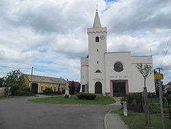 Church of Saint Kunigunde
| |
 Flag
 Coat of arms
| |
 Jevišovka Location in the Czech Republic
| |
| Coordinates: 48°49′43″N 16°27′58″E | |
| Country | Czech Republic |
| Region | South Moravian |
| District | Břeclav |
| First mentioned | 1353 |
| Area | |
| • Total | 12.65 km2 (4.88 sq mi) |
| Elevation | 177 m (581 ft) |
| Population
(2023-01-01)
| |
| • Total | 676 |
| • Density | 53/km2 (140/sq mi) |
| Time zone | UTC+1 (CET) |
| • Summer (DST) | UTC+2 (CEST) |
| Postal code | 691 83 |
| Website | www |
Jevišovka (until 1949 Frélichov; German: Fröllersdorf, Croatian: Frjelištorf, Frielištof) is a municipality and village in Břeclav District in the South Moravian Region of the Czech Republic. It has about 700 inhabitants.
Geography
Jevišovka is located about 32 kilometres (20 mi) west of Břeclav and 40 km (25 mi) south of Brno. It lies in the Dyje–Svratka Valley. It is situated at the confluence of the Jevišovka and Thaya rivers.
History
The first written mention of Jevišovka is from 1353. The village was founded by German colonists in the early 13th century. From the late 14th century until 1848, Jevišovka was property of the House of Liechtenstein as a part of the Drnholec estate.
Demographics
Jevišovka is one of the South Moravian municipalities with a historical population of Moravian Croats.