Highways in Croatia


Highways in Croatia are the main transport network in Croatia. The Croatian classification includes several classes of highways:
- The main motorway routes are prefixed with an A (for autocesta) and accompanied by one or two digits. They are controlled-access highways with tolls using a ticket system.
- Expressways (brza cesta) are toll-free limited-access highways with grade-separated intersections and fast speed limits. They are similar to the motorways, but are not always dual carriageways and they may have no emergency lanes. Their speed limit is always lower than the motorways. They either have standalone designations or are parts of non-motorway state routes, such as the D prefixed highways described further below.
- Roads dedicated for motor vehicles (cesta namijenjena isključivo za promet motornih vozila), which is another category of limited-access highways. They usually have multiple lanes and separated carriageways but may have at-grade intersections. This class of roads has no specific numbering convention, only a dedicated traffic sign. State routes (D roads) or portions thereof may be designated in this manner. An example is Jadranska Avenue in Zagreb, designated as Ž1040, a county road.
Other than the motorway routes, the national road classification includes the following enumerated categories of routes in the national highway system, with decreasing order of priority:
- State roads, which are marked by letter D (državna cesta) and a single, double or triple digit number.
- County roads always are marked by letter Ž (županijska cesta) and a four digit number.
- The lowest classification comprises local roads, marked by letter L (lokalna cesta) and a five digit number.
Road operators differ according to the classification system: The designated motorways are operated by three different concessionaires. The state roads are maintained almost exclusively by Hrvatske ceste, while the county and local roads are managed by various county authorities. The road maintenance agencies are governed by various laws issued by the Parliament as well as bylaws issued by the Ministry of Transport.
Motorways

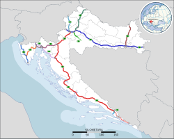
The primary high-speed motorways are called autoceste (Croatian pronunciation: [ˈaʊtotsesta]; singular: autocesta), and they are defined as roads with at least three lanes in each direction (including hard shoulder) and a speed limit of not less than 80 kilometres per hour (50 mph). They are marked with a special road sign, similar to the road sign depicting a motorway/autoroute/autobahn in other parts of Europe. The Croatian motorway (autocesta) network is 1,341.1 kilometres (833.3 mi) long.
Motorways in Croatia are defined by the Ministry of Maritime Affairs, Transport and Infrastructure. The same applies to names of the motorway interchanges and rest areas.
History
A major reason for the motorway construction "mania" of the 2000s is a previous political halt of the major Croatian highway project, today's A1, in the 1970s and 1980s under former Yugoslavia. When Croatia declared independence in 1991, the only true motorways in the country were Rijeka–Kikovica (the westernmost part of today's A6), Zagreb–Karlovac (the northernmost part of today's A1) and Zagreb–Slavonski Brod (the central part of today's A3), the latter being part of the Brotherhood and Unity Highway. The dream to connect the two largest Croatian cities Zagreb and Split with a motorway (autocesta) went back to the times of the Croatian Spring. However, the construction of this project had not happened during Yugoslav period.
In 2005, the Zagreb–Split route was constructed. In addition, the A1 was extended towards Dubrovnik (currently at Ploče), and the A3 was extended so it connects Zagreb to Croatian borders with both Serbia (near Lipovac) and Slovenia (near Bregana). There is also a motorway from Zagreb to Rijeka, the A6, as well as the A4 motorway from Zagreb to the northeast (Hungarian border) as well as the A2 motorway from Zagreb to the northwest (Slovenian border). The A9 between Pula and the Slovenian border is also largely completed.
The construction of additional motorways has noticeably slowed in the 2010s, but it continues. As of 2021, the Cerovlje–Rijeka section of A8, the remaining part of the Istrian Y, is being upgraded from semi-highway status. The other motorways are in various early stages of development, coming up to a total of 11 motorway routes. The A1 is considered unfinished as it is planned to be extended from Ploče to Dubrovnik.
Operators
The network is managed by 3 operators, of which one is under full government control and other two are operated by joint ventures.
| Operator | Ownership | Motorway | Length (in 2022) | Notes |
|---|---|---|---|---|
| BINA Istra | BINA Fincom (67%) Bouygues (16%) Hrvatske autoceste (14.8%) Istarska autocesta (2.2%) |
A8, A9 | 141.0 km (87.6 mi) | Under concession until 2041. |
| Autocesta Zagreb – Macelj | Pyhrn Concession Holding GmbH (51%) Republic of Croatia (49%) |
A2 | 60.0 km (37.3 mi) | Under concession until 2032. |
| Hrvatske autoceste | Republic of Croatia (100%) | A1, A3, A4, A5, A6, A7, A10, A11, Krk bridge | 1,140.1 km (708.4 mi) | A6 and A7 were operated by Autocesta Rijeka – Zagreb until 31 December 2020. |
Motorways and sections
List of motorways
| Motorway | Route | Length (in 2022) |
Description | Notes |
|---|---|---|---|---|
|
|
Zagreb - Split - Dubrovnik | 484.2 km (300.9 mi) | The A1 starts in Lučko interchange, a part of Zagreb bypass where the A3 motorway junction is found. The motorway proceeds south from Zagreb to Karlovac and further on to Bosiljevo 2 interchange where the A6 motorway branches off towards Rijeka. The route continues south to Gospić, Zadar, Šibenik, Split. The southernmost sector of the motorway proceeds from Split to Ploče and Metković. | Section between Ploče and Dubrovnik is planned |
|
|
Zagreb - Macelj | 60.0 km (37.3 mi) | The A2 starts on the border of Slovenia near Macelj. The motorway passes west of Krapina and proceeds south towards Zagreb. The southernmost section of the motorway forms a part of Zagreb bypass and it terminates in Jankomir interchange with the A3 motorway. | |
|
|
Bregana - Zagreb - Lipovac | 306.4 km (190.4 mi) | The A3 starts on the border of Slovenia near Bregana. The motorway passes north of Samobor and proceeds west towards Zagreb, passing to the south of the city and forming a part of Zagreb bypass, where the route contains junctions with the A2, A1 and A4 motorways. It continues east to Kutina, Slavonski Brod, Sredanci interchange with the A5 motorway and further east to Županja and terminating on the border of Serbia near Lipovac. | |
|
|
Zagreb - Goričan | 97.7 km (60.7 mi) | The A4 starts on the border of Hungary near Goričan. The motorway passes near Čakovec and Varaždin south towards Zagreb and the southernmost part of the route is a part of Zagreb bypass, where the motorway terminates in Ivanja Reka interchange, where the traffic defaults to the westbound A3 motorway. | |
|
|
Beli Manastir - Osijek - Bosnian border | 83.4 km (51.8 mi) | The A5 starts near Beli Manastir and proceeds south bypassing Osijek and Đakovo, meets the A3 motorway at Zoljani interchange and proceeds south to Svilaj border bridge where it connects on Bosnian A1 motorway. | Section to Hungarian border is under construction. |
|
|
Rijeka - Bosiljevo 2 | 81.5 km (50.6 mi) | The A6 starts in Bosiljevo 2 interchange, branching off from the A1 motorway and proceeds west bypassing Delnice to Rijeka and the Orehovica interchange with the A7 motorway. | |
|
|
Rupa - Matulji - Diračje - Orehovica - Šmrika | 44.7 km (27.8 mi) | The A7 starts at the border of Slovenia and heads south to Rijeka, passes the city as Rijeka bypass. The Rijeka bypass section comprises an interchange with the A6 motorway and proceeds east terminating near Šmrika where the traffic defaults to the D8 state road. | Section east of Rijeka is under construction. |
|
|
Kanfanar - Matulji | 64.2 km (39.9 mi) | The A8 spans between Kanfanar and Matulji, i.e. the A9 and A7 motorways. As of March 2023, the Kanfanar–Vranja section is brought to the motorway standards, and the rest is a limited access two-lane route. | |
|
|
Umag - Pula | 76.8 km (47.7 mi) | The A9 starts near Umag and the Slovenian border, meets the A8 motorway at Kanfanar interchange, and proceeds south to Pula, forming the western arm of Istrian Y. | |
|
|
Bosnian border - Ploče interchange | 9.3 km (5.8 mi) | The A10 starts at Bosnian border, where it connects to A1 motorway in Bosnia and runs to the Ploče interchange, where it connects to A1 motorway. | |
|
|
Zagreb - Sisak | 29.8 km (18.5 mi) | The A11 starts at Jakuševec interchange and runs south to Lekenik interchange. It was connected to A3 in November 2015. It is finished to Lekenik. | The last section to Sisak is under construction. |
Motorway sections under construction
| Motorway | County | Length | Section | Description | Scheduled completion |
|---|---|---|---|---|---|
|
|
Osijek-Baranja | 5.25 km (3.26 mi) | Branjin Vrh border crossing–Beli Manastir | Construction of four lane motorway started in September 2023. | April 2025 |
|
|
Primorje-Gorski Kotar | 6.5 km (4.0 mi) | Novi Vinodolski bypass | Construction began in September 2021 and will consist of two lane expressway that will match the left lane of the future motorway. | September 2024 |
|
|
Istria and Primorje-Gorski Kotar |
5.6 km (3.5 mi) | Učka Tunnel | Construction of second tunnel started in December 2020. | July 2024 |
| Primorje-Gorski Kotar | 11 km (6.8 mi) | Učka Tunnel–Matulji | Construction of additional two lanes started in September 2023. | November 2026 | |
|
|
Sisak-Moslavina | 11 km (6.8 mi) | Lekenik–Sisak | Construction of four lane motorway started in February 2022. | March 2024 |
Planned motorway sections
| Motorway | County | Length | Section | Notes |
|---|---|---|---|---|
|
|
City of Zagreb, Zagreb and Karlovac | 38.6 km (24.0 mi) | Zagreb–Karlovac | Upgrade to six lanes, the start of the works is planned for 2026. |
| Karlovac | 28.2 km (17.5 mi) | Karlovac–Bosiljevo 2 | Upgrade to six lanes. Start of works after completion of the Zagreb-Karlovac section. | |
| Dubrovnik-Neretva | 51.2 km (31.8 mi) | Metković–Osojnik (Dubrovnik) | As of 2023, the competition for the project is ongoing. | |
|
|
Krapina-Zagorje | 3.7 km (2.3 mi) | Đurmanec–Macelj | The construction of tunnels Sveta Tri Kralja and Brezovica so the section is upgraded to four lane motorway is expected to begin in the fall of 2022. |
|
|
Zagreb and City of Zagreb | 25 km (16 mi) | Jankomir–Ivanja Reka | The plan is to build an extra lane in each direction. First phase is expected to start in 2023 with the subsection Jankomir–Lučko. |
|
|
Primorje-Gorski Kotar | 18.1 km (11.2 mi) | Križišće–Novi Vinodolski | Design started in 2020 and competition for construction begun in January 2024. |
| Primorje-Gorski Kotar and Lika-Senj | 21 km (13 mi) | Novi Vinodolski–Senj | Design started in 2023. | |
| Lika-Senj | 10.8 km (6.7 mi) | Senj–Žuta Lokva | A public consultation is in progress with a planned start of design in 2024. | |
|
|
Istria | 2.5 km (1.6 mi) | Mirna Bridge and Lim Bay Viaduct | Construction of bridge and viaduct for upgrading motorway on four lanes in total, the start of the works is planned for second half of 2023. |
Traffic cost revenue
In 2022, the network had a traffic of 80,172,262 vehicles, including 70,344,584 light vehicles and 9,827,678 heavy vehicles ( difference by axle height).
The travel cost is 9.00 euros per 100 km for light vehicles in closed system and 6.00 euros in open toll system, while for heavy ones are 39.00 euros per 100 km in closed system and 21.0 in open system.
Those costs generate a revenue of 426.5 millions of euros (without VAT) in 2022.
Accidents
Two third of motorway fatalities (67%) occurred in the third of the year between July and October.
Expressways

There is a wide variety of types of expressways in Croatia, in terms of number of lanes, accessibility and types of intersections comprised. They range from four lane expressways with grade-separated intersections and limited access - distinguished from the motorways by lack of emergency lanes only - to four or six lane urban expressways with numerous at-grade intersections and traffic lights or two lane limited access roads with grade separated intersections. The expressways include both incomplete motorways, built in stages, and some state roads (with either limited access, more than two traffic lanes, grade-separated intersections or any combination thereof). There are even some instances of county roads which may be regarded expressways such as Jadranska Avenue (Ž1040).
As a rule, the expressways are not tolled; however, major tunnels on the expressways are tolled.
List of completed expressways
| Number | Control cities (or other appropriate route description) |
|---|---|
|
|
sections through Karlovac (four lane dual carriageway, with at-grade intersections) |
|
|
Dugopolje interchange (A1) - Split (four lane dual carriageway, with grade separated intersections) |
|
|
Osijek southern bypass (four lane dual carriageway, with grade separated intersections) |
|
|
sections through and near Split (four lane dual carriageway, with at-grade intersections) |
|
|
Sveta Helena interchange (A4) - Križevci (four lane dual carriageway, with grade separated intersections) |
|
|
Vrbovec 2 interchange (D10) - Farkaševac (four lane dual carriageway, with grade separated intersections) |
|
|
Zabok interchange (A2) – Zlatar Bistrica (D29) (two lane single carriageway, with grade separated intersections) |
|
|
Šibenik interchange (A1) - Šibenik (Vidici interchange) (two lane single carriageway, with grade separated intersections) |
|
|
Zagvozd (Biokovo toll booth) - Baška Voda (D8) (two/four lane single carriageway with grade separated intersections) |
|
|
Bisko interchange (A1) - Čaporice (D60) (four lane dual carriageway/two lane single carriageway, with grade separated intersections) |
|
|
Draga interchange (A7) - Rijeka (Brajdica interchange) (three/four lane single carriageway, with grade separated intersections) |
|
|
Zadar 2 interchange (A1) - Zadar (Gaženica Port) (four lane dual carriageway, with grade separated intersections) |
|
|
Karamatići toll station (A1) - Ploče (Čeveljuša interchange) (four lane dual carriageway/two lane single carriageway, with grade separated intersections) |
|
|
Gornja Ploča interchange (A1) - Udbina (two lane single carriageway, with grade separated intersections) |
State roads
State roads are defined by legislation as important routes for road traffic between various parts of the country. Classification of a road as a state road does not describe actual conditions of the road itself.
State roads in Croatia are assigned one, two or three digit numbers which generally comply with the following pattern (although there are some exceptions to the rules):
- 1-19 are assigned to trunk roads, normally of considerable length, spanning between borders of various neighboring countries. An obvious exception to this is the D9 state road; however, it spans from Bosnia and Herzegovina border and the Adriatic Sea, along the southernmost portion of Pan-European Corridor Vc.
- 20-99 are assigned to arterial roads on the mainland.
- 100s are assigned to island roads
- 200s are assigned to border crossing access roads.
- 300s are assigned to junction roads, connecting towns or cities (but not other state roads) to motorways or other major roads. Notable exceptions to this are D307 and D310 state roads, although the D307 originally did not connect to the D29, but only to the A2 motorway.
- 400s are assigned to mainland port and airport access roads.
- 500s are assigned to connecting roads, connecting two different state roads. Notable exceptions to this rule are the D503 which connects to a port and the D516 which connects to a border crossing checkpoint.
- 600s are provisional designations. For example, the road containing Pelješac bridge, from Komarna (D8) to Ston (D416), was designated as D674.
At the moment the state roads in Croatia have a combined length of 6,867.7 kilometres (4,267.4 mi).
D1 - D14
| Number | Control cities (or other appropriate route description) | Length |
|---|---|---|
|
|
Gornji Macelj (A2) - Krapina - Zagreb - Karlovac - Gračac - Knin - Sinj - Split (D8) | 419.15 km |
|
|
Dubrava Križovljanska border crossing (Slovenia) - Koprivnica - Virovitica - Sveti Đurađ- Našice - Osijek - Vukovar - Ilok border crossing (Serbia) | 347.23 km |
|
|
Goričan border crossing (Hungary) - Hodošan (A4) - Čakovec - Varaždin - Breznički Hum - Popovec (A1) - Karlovac - Rijeka (D8) | 220.65 km |
|
|
Terezino Polje border crossing (Hungary) - Virovitica - Veliki Zdenci - Donji Daruvar - Lipik - Stara Gradiška border crossing (Bosnia and Herzegovina) | 123.19 km |
|
|
Jurovski Brod border crossing (Slovenia) - Ribnik - Karlovac - Brezova Glava - Vojnić - Glina - Dvor border crossing (Bosnia and Herzegovina) | 134.65 km |
|
|
Duboševica border crossing (Hungary) - Beli Manastir - Osijek - Đakovo - Slavonski Šamac border crossing (Bosnia and Herzegovina) | 115.26 km |
|
|
Pasjak border crossing (Slovenia) - Matulji - Rijeka - Zadar - Split - Pelješac - Dubrovnik - Karasovići border crossing (Montenegro) | 657.70 km |
|
|
Metković border crossing (Bosnia and Herzegovina) - Opuzen (D8) | 10.63 km |
|
|
Sveta Helena interchange (A4) - Cugovec - Križevci - Koprivnica - Gola border crossing (Hungary) | 85.35 km |
|
|
Zabrđe (D10) - Haganj - Zvonik - Bjelovar - Virovitica - Terezino Polje border crossing (Hungary) | 90.54 km |
|
|
Mokrice (D307) - Donja Zabočka - Bedekovičina - Selnica - Podgrađe (D29) | 17.42 km |
D20 - D77
| Number | Control cities (or other appropriate route description) | Length |
|---|---|---|
|
|
Čakovec (D3) – Prelog – Donja Dubrava – Đelekovec – Koprivnica (D2) | 50.4 km |
|
|
D3 - Novi Marof – Križevci – Sveti Ivan Žabno | 42.7 km |
|
|
Duga Resa (D3) – Josipdol – Žuta Lokva – Senj (D8) | 103.9 km |
|
|
Zabok (D1) – Zlatar Bistrica – Donja Konjšćina – Budinšćina – Novi Marof – Varaždinske Toplice – Poljanec (D2) | 72.4 km |
|
|
Korenica (D1) – Bunić – Lički Osik – Gospić – Karlobag (D8) | 83.6 km |
|
|
Dubrava (D10) - Čazma - Garešnica - Dežanovac - Daruvar (D5) | 88.5 km |
|
|
Gračac (D1) - Obrovac - Benkovac - Stankovci - D8 | 96.9 km |
|
|
Gradec (D10) - Bjelovar - Veliki Zdenci (D5) | 70.7 km |
|
|
Novi Golubovec (D35) - Zlatar Bistrica - Marija Bistrica - Soblinec (D3) | 49.8 km |
|
|
Buzin interchange (A3) - Velika Gorica - Petrinja - Hrvatska Kostajnica border checkpoint (Bosnia and Herzegovina) | 83.1 km |
|
|
Velika Gorica (D30) - Gornji Viduševac - D6 | 56.1 km |
|
|
Prezid border checkpoint (Slovenia) - Delnice (D3) | 49.7 km |
|
|
Strmica border checkpoint (Bosnia and Herzegovina) - Knin - Drniš - Vidici (D8) | 73.3 km |
|
|
Slatina (D2) - Donji Miholjac - Josipovac (D2) | 79.0 km |
|
|
Varaždin (D2) - Lepoglava - Sveti Križ Začretje (D1) | 46.0 km |
|
|
Karlovac (D1) - Pokupsko - Sisak - Popovača (Ž3124) | 110.5 km |
|
|
Sisak (D36) - Petrinja - Glina (D6) | 34.4 km |
|
|
Pakrac (D5) - Požega - Pleternica - Đakovo (D7) | 120.7 km |
|
|
Bosnian Border - Aržano - Cista Provo - Šestanovac roundabout - Dubci (D8) | 37.3 km |
|
|
Sveti Kuzam interchange (A7) - D8 - Port of Bakar (West) | 3.1 km |
|
|
Gola border checkpoint - Koprivnica - Križevci (D22) | 82.9 km |
|
|
Vrbovsko (D3) - Ogulin - Josipdol - Plaški - Grabovac (D1) | 57.9 km |
|
|
Đurđevac (D2) - Bjelovar - Čazma - Ivanić Grad interchange (A3) | 78.1 km |
|
|
Nova Vas interchange (A9) - Ponte Porton - Buzet - Lupoglav interchange (A8) | 50.5 km |
|
|
Veliki Zdenci - (D5) - Garešnica - Kutina interchange A3 | 43.6 km |
|
|
Đakovo D7 -Vinkovci - Tovarnik border checkpoint (Serbia) | 73.0 km |
|
|
Lipik (D5) - Novska - Hrvatska Dubica - Hrvatska Kostajnica - Dvor (D6) | 94.5 km |
|
|
Baderna interchange (A9) - Pazin - Rogovići interchange (A8) | 20.8 km |
|
|
Pleternica - Lužani interchange (A3) | 19.2 km |
|
|
Žuta Lokva (D23) - Otočac - Gospić - Gračac (D40) | 104.2 km |
|
|
Gradište (D53) - Požega - Nova Gradiška interchange (A3) | 50.3 km |
|
|
Špilnik (D50) - Korenica (D1) | 41.1 km |
|
|
Donji Miholjac border checkpoint (Hungary) - Našice - Slavonski Brod border checkpoint (Bosnia and Herzegovina) | 91.6 km |
|
|
Maslenica (D8) - Zaton Obrovački D27 | 13.5 km |
|
|
Borovo (D2) - Vinkovci - Županja border checkpoint (Bosnia and Herzegovina) | 48.6 km |
|
|
Tromilja interchange (D424) – Benkovac – Skradin – Drniš (D33) – Muć – Klis–Grlo interchange (D1) | 119.6 km |
|
|
Vukovar (D2) - Orolik - Nijemci - Lipovac interchange A3 | 36.1 km |
|
|
Šibenik (port) - Boraja - Trogir (D8) | 43.0 km |
|
|
Knin (D8) - Kistanje - Bribirske Mostine - Putičanje - Kapela (D8) | 53.9 km |
|
|
Brnaze (D1) - Trilj - Cista Provo - Imotski - Vinjani Donji border checkpoint (Bosnia and Herzegovina) | 66.1 km |
|
|
Šestanovac (D39) - Zagvozd - Vrgorac - Kula Norinska - Metković (D9) | 89.5 km |
|
|
Pazin (D48) - Potpićan - Vozilići (D66) | 26.9 km |
|
|
Pula (D400) - Labin - Opatija - Matulji (D8) | 90.1 km |
|
|
Slatina (D2) - Čeralije - Voćin - Novo Zvečevo - Kamenska (D38) | 53.4 km |
|
|
Omiš (D8) - Naklice - Gata - Blato na Cetini interchange (A1) | 21.6 km |
|
|
Slavonski Brod: D53 - Svačićeva - I. G. Kovačića - N. Zrinskog (D423) | 2.7 km |
|
|
Đurmanec (D207) - Krapina - Bednja - Lepoglava (D35) | 22.0 km |
|
|
D200 - Savudrija - Umag - Novigrad - Poreč - Vrsar - Vrh Lima - Bale - Pula (D400) | 101.7 km |
|
|
Baško Polje (D8) – Zagvozd (D62) – Grubine (D60) – Imotski – Gornji Vinjani border checkpoint (Bosnia and Herzegovina) | 28.3 km |
|
|
Rogovići interchange (A8) – Žminj – Svetvinčenat – Vodnjan (D75) | 33.2 km |
D100 - D128
| Number | Control cities (or other appropriate route description) | Length |
|---|---|---|
|
|
Porozina (ferry port) - Cres - Mali Lošinj (Ž5159) | 80.5 km |
|
|
D100 - Merag (ferry port) | 10.9 km |
|
|
Šmrika (D8) - Krk - Baška | 48.3 km |
|
|
D102 - Rijeka Airport | 1.7 km |
|
|
D102- Valbiska (ferry port) | 10.1 km |
|
|
Lopar (ferry port) - Rab - Mišnjak (ferry port) | 22.7 km |
|
|
Žigljen (ferry port) - Novalja - Pag - Ražanac - Posedarje (D8) | 73.8 km |
|
|
Veli Rat - Savar - Sali | 41.9 km |
|
|
Muline (ferry port) - Ugljan - Tkon (ferry port) | 41.6 km |
|
|
Maslinica - Grohote - Stomorska | 17.8 km |
|
|
Rogač (ferry port) - D111 | 1.9 km |
|
|
Supetar - Nerežišće - Sumartin (ferry port) | 39.4 km |
|
|
Milna - Sutivan - Supetar (D113) | 18.8 km |
|
|
Gornji Humac (D113) - Bol | 11.4 km |
|
|
Hvar - Milna - Starigrad (ferry port) - Sućuraj | 77.8 km |
|
|
Komiža - Podhum - Vis | 19.9 km |
|
|
Vela Luka - Kapja - Dubovo - Korčula | 43.5 km |
|
|
Ubli - Lastovo | 9.5 km |
|
|
Pomena - Polače - Sobra - Saplunara | 42.9 km |
|
|
Murter - Tisno - D8 | 14.0 km |
|
|
Sobra (ferry port) - D120 | 1.1 km |
|
|
Brbinj (ferry port) - Brbinj - D109 | 1.7 km |
|
|
Zaglav (ferry port) - D109 | 1.1 km |
|
|
Trogir (D315) - Arbanija - Slatine | 8.3 km |
|
|
Uvala Mikavica - Žirje (ferry port) | 3.8 km |
Tolls
In the Republic of Croatia, primarily a closed toll system is applied to the entire motorway network tolls with multiple entrances and exits. The use of motorways is charged by mileage and vehicle category. At the entrance on the motorway, the user picks up the entrance card (or a record recorded on the ENC device) and the payment is made on exit toll stations according to the length of the trip. The open system is in use at toll stations Bregana(A3) and Rupa(A7).
Safety
Croatia had 70 road deaths per million inhabitants estimated in 2022.
See also
- Transport in Croatia
- Hrvatske autoceste
- Autocesta Rijeka – Zagreb
- BINA Istra
- Autocesta Zagreb – Macelj
- Hrvatske ceste
- List of controlled-access highway systems
- Evolution of motorway construction in European nations
- Speed limits in Croatia
Maps
- Overview map of the A1 (Map). OpenStreetMap. Retrieved December 14, 2012.
- Overview map of the A2 (Map). OpenStreetMap. Retrieved December 14, 2012.
- Overview map of the A3 (Map). OpenStreetMap. Retrieved December 14, 2012.
- Overview map of the A4 (Map). OpenStreetMap. Retrieved December 14, 2012.
- Overview map of the A5 (Map). OpenStreetMap. Retrieved December 14, 2012.
- Overview map of the A6 (Map). OpenStreetMap. Retrieved December 14, 2012.
- Overview map of the A7 (Map). OpenStreetMap. Retrieved December 14, 2012.
- Overview map of the A8 (Map). OpenStreetMap. Retrieved December 14, 2012.
- Overview map of the A9 (Map). OpenStreetMap. Retrieved December 14, 2012.
- Overview map of the A10 (Map). OpenStreetMap. Retrieved July 7, 2013.
- Overview map of the A11 (Map). OpenStreetMap. Retrieved December 14, 2012.