Gisors
Gisors | |
|---|---|
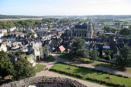 City as seen from the castle terrasse
| |
 Coat of arms
| |
|
Location of Gisors
| |
 Gisors  Gisors | |
| Coordinates: 49°16′52″N 1°46′38″E | |
| Country | France |
| Region | Normandy |
| Department | Eure |
| Arrondissement | Les Andelys |
| Canton | Gisors |
| Intercommunality | Vexin Normand |
| Government | |
| • Mayor (2022–2026) | José Cerqueira |
| Area 1
|
16.67 km2 (6.44 sq mi) |
| Population
(Jan. 2020)
|
11,863 |
| • Density | 710/km2 (1,800/sq mi) |
| Time zone | UTC+01:00 (CET) |
| • Summer (DST) | UTC+02:00 (CEST) |
| INSEE/Postal code |
27284 /27140 |
| Elevation | 47–142 m (154–466 ft) (avg. 74 m or 243 ft) |
| 1 French Land Register data, which excludes lakes, ponds, glaciers > 1 km2 (0.386 sq mi or 247 acres) and river estuaries. | |
Gisors (French pronunciation: [ʒizɔʁ]) is a commune of Normandy, France. It is located 62.9 km (39.1 mi) northwest from the centre of Paris.
Gisors, together with the neighbouring communes of Trie-Château and Trie-la-Ville, form an urban area of 13,915 inhabitants (2018). This urban area is a satellite town of Paris.
Geography
Gisors is located in the Vexin normand region of Normandy, at the confluence of the rivers Epte, Troesne and Réveillon.
Population
|
|
||||||||||||||||||||||||||||||||||||||||||||||||||||||||||||||||||||||||||||||||||||||||||||||||||||||||||||||||||
| Source: EHESS and INSEE (1968-2017) | |||||||||||||||||||||||||||||||||||||||||||||||||||||||||||||||||||||||||||||||||||||||||||||||||||||||||||||||||||
Transport
The Gisors station is the terminus of a Transilien suburban rail service from the Paris Saint-Lazare station, and of a TER Normandie local service to Serqueux.
Sights
- Château de Gisors, built in the 11th century.
- The Saint-Gervais-Saint-Protais parish church is an outstanding monument fusing Gothic and Renaissance architecture.
- A field near Gisors was the site of the Cutting of the elm, a medieval diplomatic incident.
- Château de Boisgeloup, former home and atelier of Pablo Picasso.
-
 Motte and Castle
 -
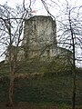 Castle of Gisors
 -
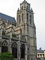 The so-called Grosse Tour ("Big Tower") of the St-Gervais-St-Protais church was built between 1542 and 1590.


