Geography of Ireland
 | |
| Continent | Europe |
|---|---|
| Region | Northwestern Europe |
| Coordinates | 53°20.65′N 6°16.05′W |
| Area | |
| • Total | 84,421 km2 (32,595 sq mi) |
| • Land | 98.2% |
| • Water | 1.8% |
| Coastline | 7,524 km (4,675 mi) |
| Highest point | Carrauntoohil 1,039 metres (3,409 ft) |
| Lowest point | North Slob −3 metres (−10 ft) |
| Longest river | River Shannon 360.5 km (224.0 mi) |
| Largest lake | Lough Neagh 392 km2 (151 sq mi) |
| Climate | temperate oceanic climate with some upland areas classified as oceanic subpolar |
| Terrain | flat, low-lying area in the midlands, ringed by mountain ranges |
| Natural resources | aquaculture, fertile soil, freshwater, timber, peat, bauxite, copper, zinc, lead, gold, silver, iron, gypsum, natural gas, hydropower, wind energy |
| Natural hazards | Cyclones, flooding, thunderstorms |
| Environmental issues | Water pollution, Leaching, Climate change, Waste disposal |
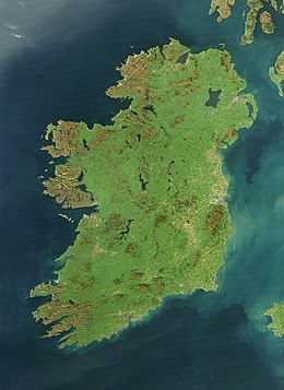
Ireland is an island in Northern Europe in the north Atlantic Ocean. The island lies on the European continental shelf, part of the Eurasian Plate. The island's main geographical features include low central plains surrounded by coastal mountains. The highest peak is Carrauntoohil (Irish: Corrán Tuathail), which is 1,039 metres (3,409 ft) above sea level. The western coastline is rugged, with many islands, peninsulas, headlands and bays. The island is bisected by the River Shannon, which at 360.5 km (224 mi) with a 102.1 km (63 mi) estuary is the longest river in Ireland and flows south from County Cavan in Ulster to meet the Atlantic just south of Limerick. There are a number of sizeable lakes along Ireland's rivers, of which Lough Neagh is the largest.
Politically, the island consists of the Republic of Ireland, with jurisdiction over about five-sixths of the island, and Northern Ireland, a constituent country of the United Kingdom, with jurisdiction over the remaining sixth. Located west of the island of Great Britain, it lies at approximately 53°N 8°W. It has a total area of 84,421 km2 (32,595 sq mi). It is separated from Great Britain by the Irish Sea and from mainland Europe by the Celtic Sea.
Ireland forms the second largest landmass in the North-West European Archipelago, together with nearby islands including Great Britain and the Isle of Man, known in the United Kingdom as the British Isles.
Geological development

The geology of Ireland is diverse. Different regions contain rocks belonging to different geological periods, dating back almost 2 billion years. The oldest known Irish rock is about 1.7 billion years old and is found on Inishtrahull Island off the north coast of Inishowen and on the mainland at Annagh Head on the Mullet Peninsula. The newer formations are the drumlins and glacial valleys as a result of the last ice age, and the sinkholes and cave formations in the limestone regions of Clare.
Ireland's geological history includes a wide range of elements, from volcanism and tropical seas to the last glacial period. Ireland was formed in two distinct parts, which slowly joined, uniting about 440 million years ago. As a result of tectonics and the effect of ice, the sea level has risen and fallen. In every area of the country, the rocks which formed can be seen as a result. Finally, the impact of the glaciers shaped the landscape seen today. The variation between the two areas, along with the differences between volcanic areas and shallow seas, led to a range of soils. There are extensive bogs and free-draining brown earths. The mountains are granite, sandstone, limestone with karst areas, and basalt formations.
Most of Ireland was probably above sea level during the last 60 million years. As such its landscapes have been shaped by erosion and weathering on land. Protracted erosion also means most of the Paleogene and Neogene sediments have been eroded away or, as known in a few cases, buried by Quaternary deposits. Before the Quaternary glaciations affected Ireland the landscape had developed thick weathered regolith on the uplands and karst in the lowlands. There has been some controversy regarding the origin of the planation surfaces found in Ireland. While some have argued for an origin in marine planation, others regard these surfaces as peneplains formed by weathering and fluvial erosion. Not only is their origin disputed but also their actual extent and the relative role of sea-level change and tectonics in their shaping. Most river systems in Ireland formed in the Cenozoic before the Quaternary glaciations. Rivers follow for most of their course structural features of the geology of Ireland. Marine erosion since the Miocene may have made Ireland's western coast retreat more than 100 km. Pre-Quaternary relief was more dramatic than today's glacier-smoothened landscapes.
Physical geography
Mountain ranges

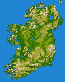
Ireland consists of a mostly flat low-lying area in what are known as the Midlands, ringed by mountain ranges such as (beginning in County Cork and working counter-clockwise) the Boggeragh Mountains, Derrynasaggart Mountains, Caha Mountains, MacGillycuddy's Reeks, Slieve Mish Mountains, Mullaghareirk Mountains, the Twelve Bens/Maumturks group, Nephinbeg Mountains, Ox Mountains, Bluestack Mountains, Derryveagh Mountains, Sperrin Mountains, the Mournes, Wicklow Mountains, Blackstairs Mountains, Comeragh Mountains and Knockmealdown Mountains. Some mountain ranges are further inland in the south of Ireland, such as the Galtee Mountains (the highest inland range), Silvermine and Slieve Bloom Mountains, and there is an area of raised land near the northeastern coast, the Antrim Plateau, which contains the Glens of Antrim; this area is sometimes called the Mountains of Antrim. The highest peak Carrauntoohil, at 1,038.6 m (3,407 ft) high, is in the MacGillycuddy's Reeks, a range of glacier-carved sandstone mountains. Only three peaks on the island are over 1,000 m (3,300 ft) and another 457 exceed 500 m (1,600 ft). There are a number of walking trails in the mountains, with the longest being that through the Wicklow Mountains, while in the Mourne Mountains a wall was built betweem the 13 major peaks, the 36-km long Mourne Wall.
Ireland is sometimes known as the "Emerald Isle" because of its green landscape.
Forests
Ireland, like the neighbouring Great Britain, was once covered in forest. Clearing of forests began in the Neolithic Age and accelerated following the Tudor Conquest, resulting in forest cover of only 1% by the start of the twentieth century. As of 2017, total tree cover in the Republic of Ireland stood at 11% of land area but the figure for native forest stood at just 2% in 2018, the third lowest in Europe, behind Iceland and Malta.
Rivers and lakes

The River Shannon, at 360.5 km (224.0 mi) in length, is the longest river in Ireland and Britain. With a drainage area of 16,865 km2 (6,512 sq mi), the Shannon River Basin covers one-fifth of the island. The Shannon crosses 11 counties and divides the west of Ireland from the south and east. The river develops into three large lakes along its course, Lough Allen, Lough Ree, and Lough Derg. The River Shannon enters the Atlantic Ocean at Limerick city along the Shannon Estuary.
Other major rivers include the River Liffey and its leading tributary, the River Dodder, and the nearby Tolka River, River Slaney, the Three Sisters (the Rivers Nore, Suir and Barrow), River Lee, River Erne, Foyle River, River Bann, River Lagan, and River Boyne. There are also multiple River Blackwaters, the most significant being the Munster Blackwater.
The river with the greatest output volume is the Shannon but the second-greatest volume is in the short but powerful River Corrib.
Lough Neagh, in Ulster, is the largest lake in Ireland and Britain with an area of 392 km2 (151 sq mi). The largest lake in the Republic of Ireland is Lough Corrib 176 km2 (68 sq mi). Other large lakes, besides the three major Shannon examples, include the two linked lakes known as Lough Erne, Lough Mask and Lough Corrib, and Lough Conn.
Inlets

In County Donegal, Lough Swilly separates the western side of the Inishowen peninsula from the wider county. Lough Foyle on the other side, is one of Ireland's larger inlets, situated between County Donegal and County Londonderry. Clockwise round the coast is Belfast Lough, between County Antrim and County Down. Also in County Down is Strangford Lough, actually an inlet partially separating the Ards peninsula from the mainland. Further south, Carlingford Lough is situated between Down and County Louth.
Dublin Bay is the next sizeable inlet. The east coast of Ireland has no major inlets until Wexford Harbour at the mouth of the River Slaney. On the south coast, Waterford Harbour is situated at the mouth of the River Suir (into which the other two of the Three Sisters (River Nore and River Barrow) flow). The next major inlet is Cork Harbour, at the mouth of the River Lee, in which Great Island is situated.
Dunmanus Bay, Kenmare estuary and Dingle Bay are all inlets between the peninsulas of western County Cork and County Kerry. North of these is the Shannon Estuary. Between north County Clare and County Galway is Galway Bay. Clew Bay is located on the coast of County Mayo, south of Achill Island, while Broadhaven Bay, Blacksod Bay and Sruth Fada Conn bays are situated in northwest Connacht, in North Mayo. Killala Bay is on the northeast coast of Mayo. Donegal Bay is a major inlet between County Donegal and County Sligo.
A recent global remote sensing analysis suggested that there were 565 km2 of tidal flats in Ireland, making it the 43rd ranked country in terms of tidal flat area.
Headlands
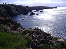
Malin Head is the most northerly point in Ireland, while Mizen Head is one of the most southern points, hence the term "from Malin to Mizen" (or the reverse) is used for anything applying to the island of Ireland as a whole. Carnsore Point is another extreme point of Ireland, being the southeasternmost point of Ireland. Hook Head and the Old Head of Kinsale are two of many headlands along the south coast. Loop Head is the headland at which County Clare comes to a point on the west coast of Ireland, with the Atlantic on the north, and the Shannon estuary to the south. Hag's Head is another headland further up Clare's north/western coastline, with the Cliffs of Moher along the coastline north of the point.
Islands and peninsulas

Achill Island, off the west coast, is the largest of Ireland's offshore islands. Achill is inhabited, and is permanently connected to the mainland by a bridge. Some of the next largest islands are the Aran Islands, off the coast of southern Connacht, host to an Irish-speaking community, or Gaeltacht. Valentia Island off the Iveragh peninsula is also one of Ireland's larger islands, and is relatively settled, as well as being connected by a bridge at its southeastern end. Omey Island, off the coast of Connemara, is a tidal island.
Some of the best-known peninsulas in Ireland are in Counties Cork and Kerry: the Dingle peninsula, the Iveragh peninsula and the Beara peninsula. Other promontories outside the southwest include the Fanad (Fannet Head), Mullet Peninsula, the Old Head of Kinsale, Hook Head, Howth Head and the Cooley Peninsula. The Inishowen peninsula in County Donegal includes Ireland's most northerly point, Malin Head, and several towns, including Buncrana on Lough Swilly, Carndonagh and Moville on Lough Foyle.
Ireland's most northerly undisputed land feature is Inishtrahull island, off Malin Head. Rockall Island lies farther north but its status is disputed, being claimed by the United Kingdom, Republic of Ireland, Denmark (on behalf of the Faroe Islands) and Iceland. The most southerly point is the Fastnet Rock.
The Hebrides off Scotland and Anglesey off Wales were grouped with Ireland ("Hibernia") by the Greco-Roman geographer Ptolemy, but this is no longer common.
Climate

The climate of Ireland is mild, humid and changeable with abundant rainfall and a lack of temperature extremes. Ireland's climate is defined as a temperate oceanic climate, or Cfb on the Köppen climate classification system, a classification it shares with most of northwest Europe. The country receives generally warm summers and mild winters. It is considerably warmer than other areas at the same latitude on the other side of the Atlantic, such as in Newfoundland, because it lies downwind of the Atlantic Ocean. It is also warmer than maritime climates near the same latitude, such as the Pacific Northwest as a result of heat released by the Atlantic overturning circulation that includes the North Atlantic Current and Gulf Stream. For comparison, Dublin is 9 °C warmer than St. John's in Newfoundland in winter and 4 °C warmer than Seattle in the Pacific Northwest in winter.
The influence of the North Atlantic Current also ensures the coastline of Ireland remains ice-free throughout the winter. The climate in Ireland does not experience extreme weather, with tornadoes and similar weather features being rare. However, Ireland is prone to eastward moving cyclones which come in from the North Atlantic.
The prevailing wind comes from the southwest, breaking on the high mountains of the west coast. Rainfall is therefore a particularly prominent part of western Irish life, with Valentia Island, off the west coast of County Kerry, getting over twice as much annual rainfall as Dublin on the east (1,557 mm or 61.3 in vs. 714 mm or 28.1 in).
January and February are the coldest months of the year, and mean daily air temperatures fall between 4 and 7 °C (39.2 and 44.6 °F) during these months. July and August are the warmest, with mean daily temperatures of 14 to 16 °C (57.2 to 60.8 °F), whilst mean daily maximums in July and August vary from 17 to 18 °C (62.6 to 64.4 °F) near the coast, to 19 to 21 °C (66.2 to 69.8 °F) inland. The sunniest months are May and June, with an average of five to seven hours sunshine per day.
Though extreme weather events in Ireland are comparatively rare when compared with other countries in the European Continent, they do occur. Atlantic depressions, occurring mainly in the months of December, January and February, can occasionally bring winds of up to 160 km/h or 99 mph to Western coastal counties; while the summer months, and particularly around late July/early August, thunderstorms can develop.
The tables below show mean 30-year climate averages for Ireland's two largest cities, taken from the weather stations at Dublin Airport and Belfast International Airport respectively. The state metrological service for the Republic of Ireland is Met Éireann, while the Met Office monitors climate data for Northern Ireland.
| Climate data for Dublin Airport (DUB), 1981–2010 normals, extremes 1881–present | |||||||||||||
|---|---|---|---|---|---|---|---|---|---|---|---|---|---|
| Month | Jan | Feb | Mar | Apr | May | Jun | Jul | Aug | Sep | Oct | Nov | Dec | Year |
| Record high °C (°F) | 17.5 (63.5) |
18.1 (64.6) |
23.4 (74.1) |
22.7 (72.9) |
26.8 (80.2) |
28.7 (83.7) |
31.0 (87.8) |
30.6 (87.1) |
27.6 (81.7) |
24.2 (75.6) |
19.4 (66.9) |
17.1 (62.8) |
31.0 (87.8) |
| Mean daily maximum °C (°F) | 8.1 (46.6) |
8.3 (46.9) |
10.2 (50.4) |
12.1 (53.8) |
14.8 (58.6) |
17.6 (63.7) |
19.5 (67.1) |
19.2 (66.6) |
17.0 (62.6) |
13.6 (56.5) |
10.3 (50.5) |
8.3 (46.9) |
13.3 (55.9) |
| Daily mean °C (°F) | 5.3 (41.5) |
5.3 (41.5) |
6.8 (44.2) |
8.3 (46.9) |
10.9 (51.6) |
13.6 (56.5) |
15.6 (60.1) |
15.3 (59.5) |
13.4 (56.1) |
10.5 (50.9) |
7.4 (45.3) |
5.6 (42.1) |
9.8 (49.6) |
| Mean daily minimum °C (°F) | 2.4 (36.3) |
2.3 (36.1) |
3.4 (38.1) |
4.6 (40.3) |
6.9 (44.4) |
9.6 (49.3) |
11.7 (53.1) |
11.5 (52.7) |
9.8 (49.6) |
7.3 (45.1) |
4.5 (40.1) |
2.8 (37.0) |
6.4 (43.5) |
| Record low °C (°F) | −15.6 (3.9) |
−13.4 (7.9) |
−9.8 (14.4) |
−7.2 (19.0) |
−5.6 (21.9) |
−0.7 (30.7) |
1.8 (35.2) |
0.6 (33.1) |
−1.7 (28.9) |
−5.6 (21.9) |
−9.3 (15.3) |
−15.7 (3.7) |
−15.7 (3.7) |
| Average precipitation mm (inches) | 62.6 (2.46) |
48.8 (1.92) |
52.7 (2.07) |
54.1 (2.13) |
59.5 (2.34) |
66.7 (2.63) |
56.2 (2.21) |
73.3 (2.89) |
59.5 (2.34) |
79.0 (3.11) |
72.9 (2.87) |
72.7 (2.86) |
758.0 (29.84) |
| Average precipitation days (≥ 1.0 mm) | 12 | 10 | 11 | 10 | 11 | 10 | 10 | 11 | 10 | 11 | 11 | 12 | 129 |
| Average snowy days | 4.6 | 4.2 | 2.8 | 1.2 | 0.2 | 0.0 | 0.0 | 0.0 | 0.0 | 0.0 | 0.8 | 2.9 | 16.6 |
| Average relative humidity (%) (at 15:00 UTC) | 80.6 | 75.7 | 71.0 | 68.3 | 68.0 | 68.3 | 69.0 | 69.3 | 71.5 | 75.1 | 80.3 | 83.1 | 73.3 |
| Mean monthly sunshine hours | 59.2 | 76.1 | 109.1 | 157.4 | 195.2 | 173.3 | 164.1 | 160.1 | 129.8 | 103.9 | 71.0 | 52.8 | 1,452 |
| Source: Met Éireann | |||||||||||||
| Climate data for Belfast (BFS), elevation: 63 m (207 ft), 1981–2010 normals, extremes 1958–present | |||||||||||||
|---|---|---|---|---|---|---|---|---|---|---|---|---|---|
| Month | Jan | Feb | Mar | Apr | May | Jun | Jul | Aug | Sep | Oct | Nov | Dec | Year |
| Record high °C (°F) | 14.0 (57.2) |
15.6 (60.1) |
20.2 (68.4) |
21.8 (71.2) |
25.0 (77.0) |
29.5 (85.1) |
30.0 (86.0) |
28.0 (82.4) |
25.6 (78.1) |
21.8 (71.2) |
16.4 (61.5) |
15.0 (59.0) |
30.0 (86.0) |
| Mean daily maximum °C (°F) | 7.1 (44.8) |
7.5 (45.5) |
9.5 (49.1) |
11.9 (53.4) |
15.0 (59.0) |
17.4 (63.3) |
19.0 (66.2) |
18.6 (65.5) |
16.4 (61.5) |
12.9 (55.2) |
9.5 (49.1) |
7.4 (45.3) |
12.7 (54.9) |
| Daily mean °C (°F) | 4.4 (39.9) |
4.6 (40.3) |
6.2 (43.2) |
8.1 (46.6) |
10.9 (51.6) |
13.6 (56.5) |
15.4 (59.7) |
15.0 (59.0) |
13.0 (55.4) |
9.9 (49.8) |
6.8 (44.2) |
4.8 (40.6) |
9.4 (48.9) |
| Mean daily minimum °C (°F) | 1.7 (35.1) |
1.6 (34.9) |
2.9 (37.2) |
4.3 (39.7) |
6.8 (44.2) |
9.7 (49.5) |
11.7 (53.1) |
11.4 (52.5) |
9.5 (49.1) |
6.9 (44.4) |
4.0 (39.2) |
2.1 (35.8) |
6.1 (43.0) |
| Record low °C (°F) | −12.8 (9.0) |
−11.1 (12.0) |
−9.9 (14.2) |
−5.1 (22.8) |
−2.8 (27.0) |
−1.2 (29.8) |
2.2 (36.0) |
2.3 (36.1) |
−0.5 (31.1) |
−3.0 (26.6) |
−8.6 (16.5) |
−14.9 (5.2) |
−14.9 (5.2) |
| Average precipitation mm (inches) | 80.3 (3.16) |
57.7 (2.27) |
67.0 (2.64) |
58.0 (2.28) |
57.3 (2.26) |
61.5 (2.42) |
71.4 (2.81) |
83.8 (3.30) |
75.6 (2.98) |
89.6 (3.53) |
79.7 (3.14) |
79.3 (3.12) |
861.2 (33.91) |
| Average precipitation days (≥ 1.0 mm) | 14.8 | 12.1 | 14.0 | 11.4 | 11.7 | 11.3 | 12.9 | 13.9 | 12.6 | 14.4 | 14.4 | 14.0 | 157.5 |
| Average snowy days | 5 | 5 | 4 | 1 | 0 | 0 | 0 | 0 | 0 | 0 | 1 | 3 | 19 |
| Average relative humidity (%) | 89 | 87 | 88 | 89 | 90 | 90 | 90 | 92 | 92 | 91 | 90 | 89 | 91 |
| Mean monthly sunshine hours | 49.7 | 71.2 | 102.5 | 153.3 | 197.7 | 167.9 | 151.3 | 142.1 | 119.9 | 91.2 | 59.4 | 46.2 | 1,352.5 |
| Source 1: Met Office NOAA (relative humidity and snow days 1961-1990) | |||||||||||||
| Source 2: KNMI | |||||||||||||
Political and human geography
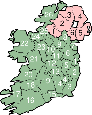
Ireland is divided into four provinces—Connacht, Leinster, Munster and Ulster—and 32 administrative counties of Ireland. Six of the nine Ulster counties form Northern Ireland and the other 26 form the state, Ireland. The map shows the county boundaries for all 32 counties.
|
(Republic of) Ireland |
Northern Ireland |
From an administrative viewpoint, 21 of the counties in the Republic are units of local government. The other six have more than one local council area, resulting in a total of 31 county-level authorities. County Tipperary had two ridings, North Tipperary and South Tipperary, originally established in 1838, renamed in 2001 and amalgamated in 2014. The cities of Dublin, Cork and Galway have city councils and are administered separately from the counties bearing those names. The cities of Limerick and Waterford were merged with their respective county councils in 2014 to form new city and county councils. The remaining part of County Dublin is divided into Dún Laoghaire–Rathdown, Fingal, and South Dublin.
Electoral areas in Ireland (the state) are called constituencies in accordance with Irish law, mostly follow county boundaries. Maintaining links to the county system is a mandatory consideration in the re-organisation of constituency boundaries by a Constituency Commission.
In Northern Ireland, a major re-organisation of local government in 1973 replaced the six traditional counties and two county boroughs (Belfast and Derry) by 26 single-tier districts, which, apart from Fermanagh cross the traditional county boundaries. The six counties and two county-boroughs remain in use for purposes such as Lieutenancy. In November 2005, proposals were announced which would see the number of local authorities reduced to seven. The island's total population of nearly 7 million people is concentrated in the east and south, particularly in Dublin, Belfast, Cork and their surrounding areas.
Natural resources
Fens and bogs

Ireland has 12,000 km2 (about 4,600 sq miles) of bogland, consisting of two distinct types: blanket bogs and raised bogs. There is also a modest amount of surviving fen, a related landform.
Raised bogs, most commonly found in the Shannon basin, are scarcer than blanket bogs. They formed when depressions left behind after the ice age filled with water to form lakes. Debris from reeds in these lakes formed a layer of at the bottom of the water. This eventually choked the lakes and raised above the surface, forming raised bogs.
Blanket bogs are essentially a product of human activity aided by the moist Irish climate, having formed on sites where Neolithic farmers cleared trees for farming. As the land so cleared fell into disuse, the soil began to leach and become more acidic, producing a suitable environment for the growth of heather and rushes. The debris from these plants accumulated and a layer of peat formed. One of the largest expanses of Atlantic blanket bog in Ireland is to be found in County Mayo.
Usage and concerns
Since the 17th century, peat has been cut for fuel for domestic heating and cooking, and it is called turf when so used. The process accelerated as commercial exploitation of bogs grew. In the 1940s, machines for cutting turf were introduced and larger-scale harvesting became possible. In the Republic, this became the responsibility of a semi-state company called Bord na Móna. In addition to domestic uses, commercially extracted turf is used in a number of industries, producing peat briquettes for domestic fuel and milled peat for electricity generation. More recently peat is being combined with biomass for dual-firing electricity generation.
In recent years, the destruction of bogs has raised environmental concerns. The issue is particularly acute for raised bogs which were more widely mined as they yield a higher-grade fuel than blanket bogs. Plans are now in place in both the Republic and Northern Ireland to conserve most of the remaining raised bogs on the island.
Oil, natural gas and minerals
Offshore exploration for natural gas began in 1970. The first major discovery was the Kinsale Head gas field in 1971. Next were the smaller Ballycotton gas field in 1989, and the Corrib gas field in 1996. Gas from these fields is pumped ashore and used for both domestic and industrial purposes. The Helvick oil field, estimated to contain over 28 million barrels (4,500,000 m3) of oil, was discovered in 2000, and Barryroe, estimated to contain 1.6 billion barrels (250,000,000 m3) of oil, was discovered in 2012, although neither have been exploited. Ireland is the largest European producer of zinc, with one zinc-lead mine currently in operation at Tara, which is Europe's largest and deepest active mine. Other mineral deposits with actual or potential commercial value include gold, silver, gypsum, talc, calcite, dolomite, roofing slate, limestone aggregate, building stone, sand and gravel.
In May 2007 the Department of Communications, Marine and Natural Resources (now replaced by the Department of Communications, Energy and Natural Resources) reported that there may be volumes over 130 billion barrels (2.1×10¹⁰ m3) of petroleum and 50 trillion cubic feet (1,400 km3) of natural gas in Irish waters – worth trillions of Euro, if true. The minimum confirmed amount of oil in the Irish Atlantic waters is 10 billion barrels (1.6×10⁹ m3), worth over €450 billion. There are also areas of petroleum and natural gas on shore, for example the Lough Allen basin, with 9.4 trillion cubic feet (270 km3) of gas and 1.5 billion barrels (240,000,000 m3) of oil, valued at €74.4 billion. Already some fields are being exploited, such as the Spanish Point field, with 1.25 trillion cubic feet (35 km3) of gas and 206 million barrels (32,800,000 m3) of oil, valued at €19.6 billion. The Corrib Basin is also quite large, worth anything up to €87 billion, while the Dunquin gas field, initially estimated to have 25 trillion cubic feet (710 km3) of natural gas and 4.13 billion barrels (657,000,000 m3) of petroleum but 2012 revised estimates suggest only 14 trillion cubic feet (400 km3) of natural gas and .5 billion barrels (79,000,000 m3) barrels of oil condensate.
In March 2012 the first commercial oil well was drilled 70 km off the Cork coast by Providence Resources, renamed Barryroe Offshore. At the time, Providence's executive Tony O'Reilly, Jr., said: It’s a defining moment for the Irish offshore oil and gas industry. The Barryroe oil well is yielding 3500 barrels per day in exploratory drilling; at current oil prices of $120 a barrel Barryroe oil well is worth in excess of €2.14bn annually. However, in 2023, the Department of the Environment, Climate and Communications declined approval of the "Lease Undertaking" that would be necessary to finish appraisal drilling and Barryroe Offshore Energy will now wind down their business by a voluntary liquidation so the field may not be developed. Legal action may be taken by investors against the Irish government including the minor 20% investor Lansdowne Oil & Gas.
Renewable energy
Under the original 2009 Renewable Energy Directive the Republic of Ireland had set a target of producing 16% of all its energy needs from renewable energy sources by 2020 but in 2018 the second Renewable Energy Directive increased the target to 32% by 2030. Between 2005 and 2014 the percentage of energy from renewable energy sources grew from just 3.1% to 8.6% of total final consumption. By 2020 the overall renewable energy share was 13.5%, short of its Renewable Energy Drive target of 16%. Renewable electricity accounted for 69% of all renewable energy used in 2020, up from two thirds (66.8%) in 2019.
Wind
While hydro generated power contributed most to Ireland's renewable energy during the during the 20th century, so far in the 21st century there has been a significant increase in the production of energy by wind spurred by climate change concerns.
Bellacorick wind farm, built by Bord na Móna in 1992, was the first Irish wind farm with an individual turbine capacity of 0.3MW which compared with the current capacity of 4–5MW means that when turbines age out, replacements will produce significantly more power per installation. As of 2022 the Republic of Ireland had more than 300 wind farms but the number will have to double by 2030 if the current 40% of renewable energy is to double. Most of the energy will have to come from inshore wind farms because the sole offshore wind farm, Arklow Bank Wind Park, only produces 0.6% of the nation's total wind energy. The 80% target is an ambitious aspect of the Climate Action Plan some impediments, such as planning permission and the age of existing wind farms, may hinder this aspiration.
A floating 400MW wind farm off the coast of Northern Ireland was proposed for the North Channel in 2022 to be operating by 2029. Another northern project, opened in October 2023, was set up under a corporate power purchase agreement in which Amazon, who backed the project, will be the off-taker of all the power produced by the 16-MW Ballykeel 7-turbine wind farm in County Antrim.
In November 2023, EDF Renewables announced their Carrowkeel Wind Farm which will be a 30 Megawatt project for County Roscommon for completion in 2028 which should power more than 20,000 homes.
Solar energy
In the 2020 Sustainable Energy Authority of Ireland's "Energy in Ireland" report solar energy only contributed only 1% of renewable energy. The obstacle of opposition to the sight of solar farms, and other forms of renewable energy, is hindering some projects.DIT School of Electrical & Electronic Engineering's Professor Barry McMullin suggests that: So while it’s the cheapest form of electricity you can get that’s only true if your demand for it happens to match when it’s available. But if what you actually want is electricity on tap, then solar PV doesn’t give you that.
Solar energy to power about 3,600 homes has been producing power with 33,600 solar modules installed on 25 hectares near Ashford, County Wicklow since April 2022. It is the first large scale such venture with a capacity of 8MW.
A forecast from ESB Networks that suggests that by the end of 2023 Ireland will be producing 1GW. This is up from the 700MW being produced in mid-summer from 60,000 micro-generation customers adding to the 371MWs of utility-scale installations. 2013 saw a new 50 million Euro solar panel scheme specially for schools in eleven counties of the republic that should save typical schools between €1,200 to €1,600 per year. Connected to the grid, the up to 6 kilowatt installation, will be most efficient when the schools are not in use.
The installed solar capacity of Northern Ireland rose to 372MW by 2022 from its initial 2MW in 2011 with the largest capacity increase in 2017 to 262MW, a figure that has been rising since then at a steady rate. The first ground-based solar farm on the island is situated in the townland of Crookedstone, County Antrim and is connected to Belfast International Airport. It provides 27% of the airport's annual energy needs. This wind farm was built by Lightsource and BP bought full control of the company in November 2023 having first invested in the company in 2017.
Hydroelectric power

Since the inception of the state, the first Shannon hydroelectric scheme was constructed in 1929 with seven years of independence. Built by Siemens-Schuckert with Irish engineers doing much of the design and using mostly Irish labour, it has an 86MW capacity with an annual generation 332GWh. This was followed up by the much larger Turlough Hill and only pumped-storage built into the mountain with a capacity of 292 megawatts completed in 1974 after 6 years of construction. A few other smaller hydroelectric stations exist around the country, such as Pollaphuca and Inniscarra Dam. Catherine Halpin, Ardnacrusha's plant manager suggests that the four main hydro plants are availing of about 70% of the country's water resources.
A tidal energy system is in operation since 2008 in Strangford Lough producing 1.2 megawatts using an underwater windmill, whose rotors at driven by the tidal currents. It has a capacity to produce enough electricity for about 1,000 homes.