Chita, Zabaykalsky Krai
|
Chita
Чита
| |
|---|---|
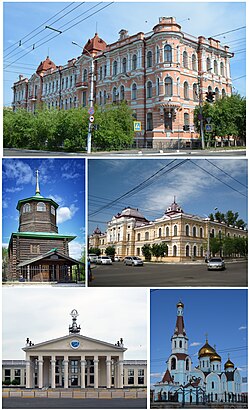 Shumovs Merchants' House, Museum "Church of the Decembrists", Pedagogical Institute Chita, Airport, Cathedral of the Kazan Icon of the Mother of God
| |
 Flag
 Coat of arms
| |
|
Location of Chita
| |
 Chita Location of Chita
 Chita Chita (Zabaykalsky Krai)
| |
| Coordinates: 52°03′N 113°28′E | |
| Country | Russia |
| Federal subject | Zabaykalsky Krai |
| Administrative district | Chitinsky District |
| Founded | 1653 |
| City status since | July 11, 1851 |
| Government | |
| • Mayor | Evgeniy Yarilov |
| Elevation | 650 m (2,130 ft) |
| Population | |
| • Total | 324,444 |
| • Estimate (2018)
|
349,005 (+7.6%) |
| • Rank | 56th in 2010 |
| • Capital of | Zabaykalsky Krai, Chitinsky District |
| • Urban okrug | Chita Urban Okrug |
| • Capital of | Chita Urban Okrug |
| Time zone |
UTC+9 (MSK+6 |
| Postal code(s) | 672000–672051 |
| Dialing code(s) | +7 3022 |
| OKTMO ID | 76701000001 |
| Website | www |
Chita (Russian: Чита, IPA: [tɕɪˈta]) is a city and the administrative center of Zabaykalsky Krai, Russia, located on the Trans-Siberian Railway route, roughly 900 kilometers (560 mi) east of Irkutsk. Population: 334,427 (2021 Census); .
History

Pyotr Beketov's Cossacks founded Chita in 1653. The name of the settlement apparently came from the local River Chita.
Following the Decembrist revolt of 1825, from 1827 several of the Decembrists suffered exile to Chita. According to George Kennan, who visited the area in the 1880s, "Among the exiles in Chita were some of the brightest, most cultivated, most sympathetic men and women that we had met in Eastern Siberia."
When Richard Maack visited the city in 1855, he saw a wooden town, with one church, also wooden. He estimated Chita's population at under 1,000, but predicted that the city would soon experience fast growth, due to the upcoming annexation of the Amur valley by Russia.
By 1885, Chita's population had reached 5,728, and by 1897 it increased to 11,500. In 1897 the Trans-Siberian Railway reached Chita; rail traffic from 1899 rapidly made Chita the transport hub and industrial centre of the Transbaikal.
During the Russian Revolution of 1905, revolutionary socialists declared the Chita Republic. Tsarist government forces took control again in January 1906.
The Bolsheviks took power in Chita in February 1918. The Imperial Japanese Army occupied Chita from September 1918 to 1920 in the course of the Siberian intervention. On behalf of the White movement, Ataman Grigory Semyonov's Eastern Okraina ruled from Chita for some few months in early 1920 with Japanese support. From October 1920 to November 1922 the city served as the capital of the Far Eastern Republic, which became part of the RSFSR in November 1922.
In 1945, the Soviet authorities held Puyi, who had reigned (1908–1912, 1917) as the last Emperor of China, and some of his associates as prisoners in the city, in a former sanatorium for officers.
-
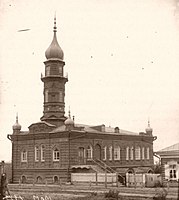 Chita Mosque in 1902
 -
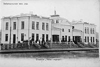 Chita railway station in 1910
 -
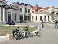 Chita railway station today


Geography
Chita lies at the confluence of the Chita and Ingoda Rivers, between the Yablonoi Mountains to the west and the Chersky Range to the east. Lake Kenon is located to the west, within the city limits, and the Ivan-Arakhley Lake System is a group of lakes lying about 50 km (31 mi) west of Chita.
Climate
Chita experiences a dry-winter borderline humid continental climate/subarctic climate (Köppen climate classification: Dwb/Dwc) with very cold, very dry winters and warm, relatively wet summers. The coldest temperature to have ever been recorded in Chita was −49.6 °C (−57.3 °F).
| Climate data for Chita (1991–2020, extremes 1890–present) | |||||||||||||
|---|---|---|---|---|---|---|---|---|---|---|---|---|---|
| Month | Jan | Feb | Mar | Apr | May | Jun | Jul | Aug | Sep | Oct | Nov | Dec | Year |
| Record high °C (°F) | 0.4 (32.7) |
7.4 (45.3) |
21.1 (70.0) |
29.3 (84.7) |
34.6 (94.3) |
38.8 (101.8) |
38.0 (100.4) |
40.6 (105.1) |
30.9 (87.6) |
22.7 (72.9) |
12.7 (54.9) |
5.0 (41.0) |
40.6 (105.1) |
| Mean daily maximum °C (°F) | −17.2 (1.0) |
−9.5 (14.9) |
0.0 (32.0) |
9.7 (49.5) |
18.2 (64.8) |
24.9 (76.8) |
26.7 (80.1) |
23.7 (74.7) |
16.8 (62.2) |
7.0 (44.6) |
−6.0 (21.2) |
−15.7 (3.7) |
6.6 (43.9) |
| Daily mean °C (°F) | −24.6 (−12.3) |
−18.3 (−0.9) |
−8.1 (17.4) |
2.2 (36.0) |
10.2 (50.4) |
17.1 (62.8) |
19.5 (67.1) |
16.6 (61.9) |
9.2 (48.6) |
−0.1 (31.8) |
−12.5 (9.5) |
−22.1 (−7.8) |
−0.9 (30.4) |
| Mean daily minimum °C (°F) | −30.4 (−22.7) |
−25.9 (−14.6) |
−16.0 (3.2) |
−5.0 (23.0) |
2.2 (36.0) |
9.2 (48.6) |
12.7 (54.9) |
10.4 (50.7) |
2.7 (36.9) |
−6.0 (21.2) |
−18.0 (−0.4) |
−27.4 (−17.3) |
−7.6 (18.3) |
| Record low °C (°F) | −49.6 (−57.3) |
−48.0 (−54.4) |
−45.3 (−49.5) |
−29.6 (−21.3) |
−13.3 (8.1) |
−5.4 (22.3) |
0.1 (32.2) |
−3.0 (26.6) |
−10.8 (12.6) |
−33.1 (−27.6) |
−41.1 (−42.0) |
−47.8 (−54.0) |
−49.6 (−57.3) |
| Average precipitation mm (inches) | 3 (0.1) |
2 (0.1) |
4 (0.2) |
12 (0.5) |
27 (1.1) |
59 (2.3) |
88 (3.5) |
85 (3.3) |
41 (1.6) |
10 (0.4) |
5 (0.2) |
5 (0.2) |
341 (13.4) |
| Average extreme snow depth cm (inches) | 7 (2.8) |
7 (2.8) |
2 (0.8) |
1 (0.4) |
0 (0) |
0 (0) |
0 (0) |
0 (0) |
0 (0) |
0 (0) |
3 (1.2) |
6 (2.4) |
7 (2.8) |
| Average rainy days | 0 | 0 | 1 | 5 | 11 | 16 | 18 | 17 | 13 | 5 | 0.2 | 0 | 86 |
| Average snowy days | 15 | 9 | 8 | 7 | 3 | 0.03 | 0 | 0 | 1 | 7 | 11 | 15 | 76 |
| Average relative humidity (%) | 76 | 72 | 59 | 47 | 46 | 58 | 68 | 73 | 66 | 61 | 70 | 77 | 64 |
| Mean monthly sunshine hours | 139 | 179 | 239 | 242 | 277 | 279 | 247 | 226 | 212 | 190 | 134 | 108 | 2,472 |
| Source 1: Pogoda.ru.net | |||||||||||||
| Source 2: NOAA (sun, 1961–1990) | |||||||||||||
| Year | Pop. | ±% |
|---|---|---|
| 1897 | 12,000 | — |
| 1926 | 57,982 | +383.2% |
| 1939 | 102,620 | +77.0% |
| 1959 | 171,816 | +67.4% |
| 1970 | 241,364 | +40.5% |
| 1979 | 302,577 | +25.4% |
| 1989 | 365,754 | +20.9% |
| 2002 | 316,643 | −13.4% |
| 2010 | 324,444 | +2.5% |
| 2021 | 334,427 | +3.1% |
| Source: Census data | ||
Administrative and municipal status
Chita is the administrative center of Zabaykalsky Krai, and, within the framework of administrative divisions, it also serves as the administrative center of Chitinsky District, to which it is also subordinated. As a municipal division, the city of Chita together with one rural locality in Chitinsky District is incorporated as Chita Urban Okrug.
City districts
The city is subdivided into four administrative districts: Chernovsky (named after the Chernovskiye coal mines and colloquially known as "Chernovskiye"), Ingodinsky (named after the Ingoda River), Tsentralny, and Zheleznodorozhny.
Chernovsky Administrative District used to be a mining settlement, which was incorporated into Chita in 1941. Chernovskiye mines themselves are a geological nature monument of international status.
Transportation
Chita is served by Kadala Airport, situated 15 km to the west.
Education
Chita is home to several facilities of higher education:
- Transbaikal State University (formerly Chita State University)
- Chita State Academy of Medicine
Military
Chita Northwest air base is located nearby, as well as the 101st (Hub) Communications Brigade and the 53rd Material Support Regiment.
Sports
FC Chita is Chita's association football club.
An indoor arena for speed skating is planned.
Twin towns – sister cities
Chita is twinned with:
- Hailar District, China (1992)
- Choibalsan, Mongolia (1994)
- Manzhouli, China (1999)
- Hulunbuir, China (2001)
- Ulan-Ude, Russia (2011)
Notable people
- Yevgeni Alkhimov (born 1977), Russian professional footballer
- Nataliya Kuznetsova (born 1991), Russian professional female bodybuilder who holds the world armlifting, bench press, and deadlift titles
- Oleg Lundstrem (1916–2005), Soviet and Russian jazz composer
- Igor Mirnov (born 1984), Russian professional ice hockey player
- Ivan Nagibin (born 1986), Russian professional football player
- Lev Okhotin (1911–1948), member of the Supreme Council of the Russian Fascist Party
- Aleksandr Perfilyev (1895–1973), Russian journalist, poet and writer
- Anastasia Pivovarova (born 1990), Russian professional tennis player
- Boris Polevoy (1918–2002), Russian historian
- Aleksandra Samusenko (1922–1945), Soviet Tank Captain, Sole female tank commander in 1st Guards Tank Army
- Volodymyr Shkidchenko (born 1948), Ukrainian military, General of Army of Ukraine
- Sergei Smirnov (born 1950), Russian security services official
- Anatoly Sobchak (1937–2000), Russian politician
- Vitaly Solomin (1941–2002), Soviet and Russian actor, director and screenwriter
- Yury Solomin (born 1935), Soviet and Russian actor and director
- Alina Stadnik (born 1991), Ukrainian female wrestler
- Alexander Stranichkin (born 1955), Abkhazian politician
- Lyudmila Titova (born 1946), Russian speed skater
- Dmytro Tymchuk (born 1972), Ukrainian military expert and blogger
- Yemelyan Yaroslavsky (1878–1943), Russian revolutionary, Soviet politician, communist party organizer
- Oksana Zhnikrup (1931-1993), Ukrainian ceramicist, whose works inspired Jeff Koons
- Stanislav Drobyshevsky (born 1978), Russian anthropologist and science popularizer