Charolais-Brionnais region
|
Charolais-Brionnais region
Pays Charolais-Brionnais
| |
|---|---|
Natural region | |
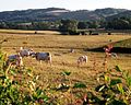
 Bocage landscape in the Arconce valley
| |
 Charolais-Brionnais region | |
| Coordinates: 46.3756°N 4.17181945806°E / 46.3756; 4.17181945806 | |
| Country | France |
| Region | Bourgogne-Franche-Comté |
| Department | Saône-et-Loire |
| Arrondissement | Charolles |
| Capital | Paray-le-Monial |
| Area | |
| • Total | 2,500 km2 (1,000 sq mi) |
| Population | |
| • Total | 90,000 |
| • Density | 36/km2 (93/sq mi) |
| Website | www |
The Charolais-Brionnais region (French: Pays Charolais-Brionnais) is located in the southwest of the French department of the Saône-et-Loire in Burgundy. Created in 2004, the region comprises a population of 90,000 inhabitants across 129 municipalities.
Geography
The Charolais-Brionnais region is home to the renowned Charolais cattle and is an applicant for UNESCO status as a World Heritage Site to preserve, consolidate and transmit this resource.
The Loire River, flanked by its adjoining canals, flows on the western edge of Charolais-Brionnais. The EuroVelo long-distance cycling route EV6, also named the Rivers Route, leaves the Loire at Digoin for the Canal du Centre, where it starts its way through the Charolais.
The Charolais-Brionnais was awarded with two food certifications of the European Union (protected designation of origin; French: Appellation d'origine protégée) for AOP Charolles Beef and AOP Charolais Goat Cheese.
-
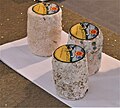 Charolais goat cheese
 -


Noteworthy landmarks and towns
- Paray-le-Monial, nicknamed the city of the Sacred Heart
- Charolles, nicknamed the Venice of the Charolais
- Bourbon-Lancy, a spa town with a 2,000-year history
- La Clayette and its 14th- and 19th-century castle
- Semur-en-Brionnais and its 9th-century castle, one of the oldest in Burgundy
-

-

-
 Château de La Clayette in the Brionnais
 -
 Medieval center of Bourbon-Lancy


