The cartography of the region of Palestine, also known as cartography of the Holy Land and cartography of the Land of Israel, is the creation, editing, processing and printing of maps of the region of Palestine from ancient times until the rise of modern surveying techniques. For several centuries during the Middle Ages it was the most prominent subject in all of cartography, and it has been described as an "obsessive subject of map art".
The history of the mapping of Palestine is dominated by two cartographic traditions: the biblical school and the classical school. The earliest surviving maps of the biblical tradition derive from the attempts of the early Church Fathers to identify and illustrate the primary locations mentioned in the Bible, and to provide maps for Christian pilgrimage. The earliest surviving maps of the classical tradition derive from the scientific and historical works of the Greco-Roman world; the European rediscovery of Ptolemy's works in the 1400s ended the domination of the biblical tradition. Many Graeco-Roman geographers described the Palestine region in their writings; however, there are no surviving pre-modern originals or copies of these maps – illustrations today of maps according to geographers such as Hecataeus, Herodotus or Eratosthenes are modern reconstructions. The earliest surviving classical maps of the region are Byzantine versions of Ptolemy's 4th Asia map. Cartographic history of Palestine thus begins with Ptolemy, whose work was based on that of the local geographer Marinus of Tyre.
The first lists of maps of the region were made in the late 19th century, by Titus Tobler in his 1867 Geographical Bibliography of Palestine and subsequently by Reinhold Röhricht in his 1890 Geographical Library of Palestine. In a series of articles in the Journal of the German Association for the Study of Palestine between 1891 and 1895, Röhricht presented the first detailed analysis of maps of the region in the middle- and the late Middle Ages. They were followed in 1939-40 by Hans Fischer's History of the Cartography of Palestine. This article lists maps that progressed the cartography of region before the rise of modern surveying techniques, showing how mapmaking and surveying improved and helped outsiders to better understand the geography of the area. Imaginary maps and copies of existing maps are excluded.
Notable maps of Palestine
Early maps (2nd–10th centuries)
| Date
|
Title
|
Cartographer
|
Comments
|
Region name given
|
Image
|
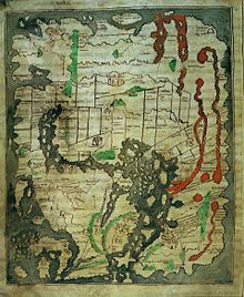
| 150 |
Ptolemy's 4th Asia map |
Ptolemy and Marinus of Tyre
|
Considered the "prototype delineation" of the region, Ptolemy's map was based on a lost work by Marinus, born in neighboring Tyre. The earliest known copy, pictured here, is the Codex Vaticanus Urbinas Graecus 82, thought to be from a manuscript of Ptolemy's Geography assembled by Maximus Planudes in Constantinople c. 1300.
|
The large red letters in the center say in Greek: Παλαιστινης or Palaistinis.
|

|
| 385 |
Jerome map |
Jerome and Eusebius
|
The earliest known copy is from 1150, the "Tournai map of Asia", shown here. The map comes from a manuscript of Jerome's De situ et nominibus locorum Hebraeorum, which Jerome states is a copy of Eusebius's Onomasticon. Jerome also explains that Eusebius composed a map which showed the divisions of the Twelve Tribes; no copy of this division has survived.
|
no regional name shown
|
|
| 410 |
Notitia Dignitatum |
unknown |
Notitia Dignitatum of c. 410 AD showing Dux Palestinae, a military region of the Byzantine Empire. This 1436 manuscript by Peronet Lamy is the earliest known copy to survive complete; it was modelled after the lost "Codex Spirensis".
|
Dux Palastinae
|
|
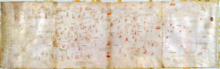
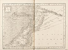
| 450 |
Tabula Peutingeriana |
unknown |
Thought to be the only surviving map of the Roman cursus publicus, the state-run road network; the surviving map was created by a monk in Colmar in eastern France in 1265, is named after German antiquarian Konrad Peutinger, and is conserved at the Austrian National Library in Vienna.
|
Palestina
|
|
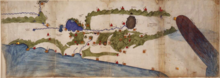
|
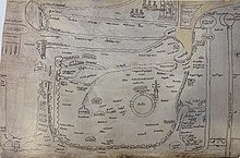
c.560–565 |
Madaba Map |
unknown |
The earliest map of Palestine surviving in its original form, and the oldest known geographic floor mosaic in art history. The mosaic was discovered in 1884, but no research was carried out until 1896. It has been heavily used for the localisation and verification of sites in Byzantine Palaestina Prima. It is the earliest surviving map showing the divisions of the Twelve Tribes.
|
Labels Greek: οροι Αιγυπτου και Παλαιστινης, oroi Aigyptou kai Palaistinis, the "border of Egypt and Palestine".
|

|
| 776 |
Beatus map |
Beatus of Liébana |
The first medieval Christian world map of relevance to the cartography of Palestine. This copy from 1060 is thought to be the closest to the original out the 14 surviving manuscripts.
|
no regional name shown
|

|
| 952 |
Istakhri map |
Istakhri |
Drawn in 952 AD, copy from 1298.
|
no regional name shown
|
|
| 995 |
Cotton map |
unknown |
Known as the "Anglo-Saxon" world map. The earliest known map of the world (rather than just the region) showing the divisions of the Twelve Tribes. Thought to be based on the map of Orosius, which is no longer extant.
|
no regional name shown
|
|
Crusader maps (12th–14th centuries)
| Date
|
Title
|
Cartographer
|
Comments
|
Region name given
|
Image
|
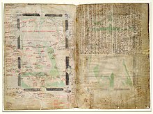
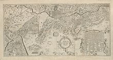
| 1154 |
Tabula Rogeriana |
Muhammad al-Idrisi |
The Tabula Rogeriana was created in 1154AD; copy from 1533.
|
The middle of the right hand page label Arabic: فلسطين, romanized: Filasṭīn, lit. 'Palestine'
|

|
| 1100s |
Ashburnham Libri map |
unknown |
Europe’s oldest surviving sheet map after the ninth-century Plan of Saint Gall.
|
no regional name shown
|
|
| 1100s |
Tournai map |
unknown |
12th century copy of a map of Asia may which accompanied a manuscript of De situ et nominibus locorum Hebraeorum, a 4th-5th century work of Jerome.
|
no regional name shown
|

|
| 1250 |
Oxford Outremer map |
Matthew Paris |
Created in c.1250, thought to be by Matthew Paris
|
The Kishon River has the following text along it: Latin: Iste torrens q[ui] parvus est, dividit Siriam a palestinam, i[d est] terram sactam q[ue] est versus austrum et palestinam que est versus aquilonem, lit. 'This river, which is small, divides Syria from Palestine, that is, the Holy Land, which is to the south, and Palestine, which is to the North.'
|
|
| 1300 |
Earliest Burchard map |
Burchard of Mount Sion |
Considered to be the oldest known Burchard map.
|
no regional name shown
|
|
| 1300s |
Later Burchard map |
Burchard of Mount Sion |
A later map attributed to Burchard.
|
no regional name shown
|

|
| 1321 |
Sanudo-Vesconte map |
Pietro Vesconte |
Described by Adolf Erik Nordenskiöld as "the first non-Ptolemaic map of a definite country". Published in Liber Secretorum Fidelium Crucis, a work intended to rekindle the spirit of the crusades. Considered the "first 'modern map' of Palestine" and "served as the basis for most maps of 'Modern Palestine'" throughout the following centuries.
|
Terra Sancta
|

|
Notable 15th–18th century maps
| Date
|
Title
|
Cartographer
|
Comments
|
Region name given
|
Image
|
| 1459 |
Fra Mauro map |
Fra Mauro |
1459 world map, considered the most accurate of its age. Fra Mauro had become familiar with the Near East in his travels as s soldier.
|
Shows the region of "Palestina"
|

|
| 1475 |
Berlinghieri map |
Francesco Berlinghieri |
Published in the Rudimentum Novitorium it was a version of Ptolemy's map, brought up to date. Together with three updated maps of European countries, Adolf Erik Nordenskiöld described it as the "first germ of modern cartography"
|
Named "Palestina Moderna et Terra Sancta" (Modern Palestine and the Holy Land)
|

|
| 1532 |
Ziegler map |
Jacob Ziegler |
1532 map by Jacob Ziegler The map is important to the development of the cartography of Palestine as it represents an early synthesis of multiple sources, including Burchard of Mount Sion, Sanuto, Ptolemy, Strabo, Pliny the Elder, the Antonine Itinerary, Jerome and Eusebius.
|
"Universalis Palaestinae, continens superiores partuculares tabulas"
|
|
| 1537 |
Mercator map |
Gerardus Mercator |
1537 map by Gerardus Mercator, three decades before he published his famous Mercator projection. This map was Mercator's first published map, and was based on the map of Jacob Ziegler.
|
The caption "Candido lectori s[alus]. Palestinam hanc..." translates as: "Fair reader, greeting! We have drawn this map of Palestine, and the Hebrews' route into it from Egypt through the stony regions of Arabia"
|
|
| 1570 |
Ortelius map |
Abraham Ortelius |
1570 map in Theatrum Orbis Terrarum. Ortelius's depiction of a biblical Palestine in his otherwise contemporary atlas has been criticized; Matari described it as an act "loaded with theological, eschatological, and, ultimately, para-colonial Restorationism".
|
Captioned "Palaestinae Sive Totius Terrae Promissionis Nova Descriptio" ("Palestine, the whole of the Promised Land, a new description")
|

|
| 1590 |
van Adrichem map |
Christian van Adrichem |
van Adrichem was a Dutch priest; his maps were published in his Theatrum Terrae Sanctae et Biblicarum Historiarum.
|
Terra Promissionis
|

|
| 1620 |
Zaddik map |
Jacob ben Abraham Zaddiq |
A translation into Hebrew of van Adrichem's 1590 map, it is the oldest known printed map in Hebrew.
|
The first line of the framed colophon includes the description: Hebrew: ציור מצב ארצות כנען, lit. 'A Drawing of the Situation of the Lands of Canaan'
|

|
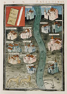
| 1648–1657 |
Celebi map |
Kâtip Çelebi |
This 1732 copy of the map by Ottoman geographer Kâtip Çelebi (1609–57) is from the first printed atlas in the Ottoman Empire, and represented the first detailed mapping of the Asian provinces of the empire.
|
Shows the term ارض فلسطين ("Land of Palestine") extending vertically down the length of the Jordan River.
|

|
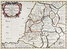
| 1651 |
De la Rue map |
Philippe de La Rue |
From the 1651 six-map atlas La Terre sainte en six cartes géographiques. It was the first published historical atlas in world cartography, in systematically chronological order. The other five maps covered land of Canaan and the Exodus, the Promised Land, Solomon's kingdom, the land of the Jews at the time of Christ, and the Christian Patriarchate of Jerusalem.
|
Sourie and Terre Saincte.
|
|
| 1655 |
Heidmann map |
Christoph Heidmann |
Published almost three decades after his death, this map accompanied his Palestina siue Terra Sancta
|
Palestina and Terre Sanctae
|

|
| 1714 |
Reland map |
Adriaan Reland |
1714 map |
Palaestinae |
|
| 1745 |
Pococke map |
Richard Pococke |
1745 map |
Holy Land and Syria |
|
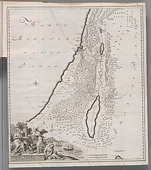
| 1769 |
Bachiene and Maas map |
Bachiene and Maas |
1769 map |
Palaestina |

|
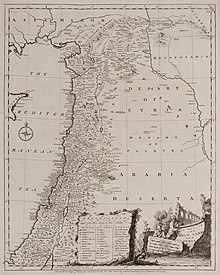
| 1794 |
d'Anville map |
Jean Baptiste Bourguignon d'Anville |
Published 1794, almost thirty years after his 1767 map of Biblical Palestine.
|
Palestina
|

|
Notable 19th century maps
| Date
|
Title
|
Cartographer
|
Comments
|
Region name given
|
Image
|
| 1799 |
Carte de l'Égypte (Description de l'Égypte) |
Pierre Jacotin |
Originally prepared during the French campaign in Egypt and Syria; 47 sheets were prepared, with the Palestine area being covered by sheets 43-47. The first triangulation-based map of Palestine, it was used as the basis for many most maps of the region until the PEF Survey in the 1870s. It is considered flawed, primarily since it included a significant number of incorrect or imagined details, which had been “added to the map ad libitum where the French had not been able to survey.”
|
Palestine
|
|
| 1803 |
Cedid Atlas |
Müderris Abdurrahman Efendii |
The first modern printed atlas in the Ottoman Empire, part of the Nizam-I Cedid reforms of Sultan Selim III, showing Ottoman Syria in the 1803. Considered to be based on the d'Anville 1794 map (published in William Faden's General Atlas), it contained important adaptations to represent Ottoman geographic representations of the provinces.
|
Shows the term "ارض فلاستان" ("Land of Palestine") in large script on the bottom left.
|

|
| 1815 |
Arrowsmith map |
Aaron Arrowsmith |
The title "A Sketch of the Countries between Jerusalem and Aleppo" is likely a reference to Henry Maundrell's Journey from Aleppo to Jerusalem published in 1703; the map's description of Jacob's Well is a direct quote from Maundrell. The map also quotes Ulrich Jasper Seetzen, whose Brief Account of the Countries Adjoining the Lake of Tiberias, the Jordan and the Dead Sea was published in 1809. The map is a combination of a modern map and a biblical map (showing the Twelve Tribes)
|
Pashalic of Acre
|
|
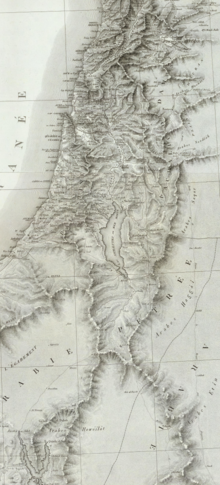
| 1822 |
Burckhardt map |
Johann Ludwig Burckhardt |
Map accompanying Burckhardt's Travels in Syria and the Holy Land, published in 1822, five years after his travels in the region. |
Syria and the Holy Land
|

|
| 1830 |
Hall map |
Sidney Hall |
1830 map shows the Ottoman divisions |
Palestine |
|
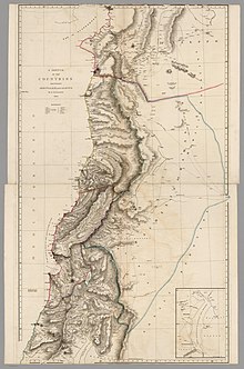
| 1840 |
Royal Engineers map |
Charles Rochfort Scott |
The first British army survey, carried out during the Oriental Crisis of 1840. It represented the second modern, triangulation-based, attempt at surveying Palestine. It was not published at the time; although a private printing for the British Foreign Office was produced in 1846, and it was used in the creation of Van de Velde's map.
|
none
|
|
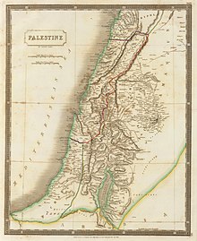
| 1841 |
Kiepert map |
Heinrich Kiepert |
Published in 1841 to accompany the first edition of Biblical Researches in Palestine by Edward Robinson, known as the "Father of Biblical Geography", and again in 1856 to accompany the second edition.
|
Palestine
|

|
| 1843 |
Hughes map |
William Hughes |
Shows the Ottoman administrative districts in detail, made for the Society for the Diffusion of Useful Knowledge. Hughes had been producing popular maps of Palestine for almost a decade, notably in his 1840 Illuminated Atlas of Scripture geography.
|
Palestine
|

|
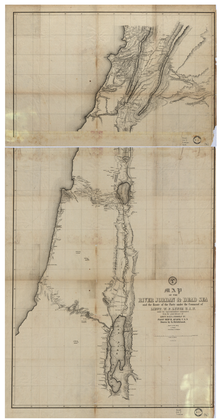
| 1849 |
Lynch map |
William F. Lynch |
Prepared on behalf of the United States Hydrographic Office. Published in Narrative of the United States' Expedition to the River Jordan and the Dead Sea. |
The Dead Sea and River Jordan
|
|
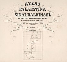
| 1850 |
Zimmermann map |
Carl Zimmermann |
The Atlas von Palaestina und der Sinai Halbinsel, in 15 sectional sheets. Part of a wider Atlas of Asia, published as a supplement to Carl Ritter's Erdkunde
|
Palaestina
|
|
| 1858 |
Van de Velde map |
Charles William Meredith van de Velde |
Published in 1858. One of the most accurate maps published prior to the PEF Survey.
|
The Holy Land
|

|
| 1870 |
Leves en Galilee |
Jean-Joseph Mieulet and Isidore Derrien |
A follow-up to a map of Lebanon. It was intended to be the first part of a complete coverage of Palestine, but the expedition was recalled to France at the outbreak of the Franco-Prussian war. It was published in 1873.
|
Galilee
|

|
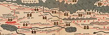
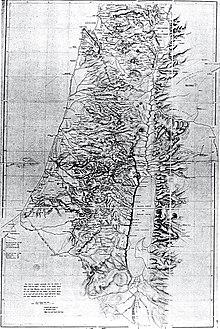
| 1872-1880 |
PEF Survey |
Charles Wilson and others |
Carried out by the Palestine Exploration Fund, with support from the War Office. Represented the peak of the cartographic work in Palestine in the nineteenth century.
|
26 sheets of "Western Palestine" and 1 sheet of "Eastern Palestine".
|

|
Modern cartography
Biblical / imaginary maps
See also


