Carrollton Township, Carroll County, Indiana
Carrollton Township | |
|---|---|
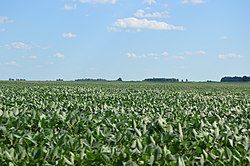 Cornfield southeast of Sharon
| |
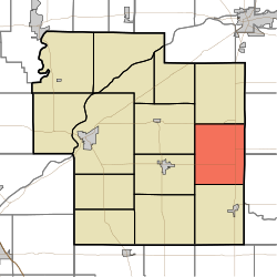 Location of Carrollton Township in Carroll County
| |
| Coordinates: 40°33′36″N 86°25′12″W | |
| Country | United States |
| State | Indiana |
| County | Carroll |
| Government | |
| • Type | Indiana township |
| Area | |
| • Total | 29.59 sq mi (76.6 km2) |
| • Land | 29.58 sq mi (76.6 km2) |
| • Water | 0.01 sq mi (0.03 km2) |
| Elevation | 725 ft (221 m) |
| Population
(2010)
| |
| • Total | 598 |
| • Density | 20.2/sq mi (7.8/km2) |
| FIPS code | 18-10540 |
| GNIS feature ID | 453160 |
Carrollton Township is one of fourteen townships in Carroll County, Indiana. As of the 2010 census, its population was 598 and it contained 244 housing units.
History
Carrollton Township was organized in 1835.
Geography
According to the 2010 census, the township has a total area of 29.59 square miles (76.6 km2), of which 29.58 square miles (76.6 km2) (or 99.97%) is land and 0.01 square miles (0.026 km2) (or 0.03%) is water.
Unincorporated towns
Adjacent townships
- Washington Township (north)
- Deer Creek Township, Cass County (northeast)
- Ervin Township, Howard County (east)
- Burlington Township (south)
- Jackson Township (west)
- Monroe Township (west)