Brandenberg
Brandenberg | |
|---|---|
 View of Brandenberg
| |
 Coat of arms
| |
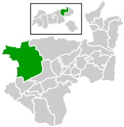 Location within Kufstein district
| |
 Brandenberg Location within Austria
| |
| Coordinates: 47°30′29″N 11°53′27″E | |
| Country | Austria |
| State | Tyrol |
| District | Kufstein |
| Government | |
| • Mayor | Hans Jürgen Neuhauser |
| Area | |
| • Total | 130.17 km2 (50.26 sq mi) |
| Elevation | 919 m (3,015 ft) |
| Population
(2018-01-01)
| |
| • Total | 1,523 |
| • Density | 12/km2 (30/sq mi) |
| Time zone | UTC+1 (CET) |
| • Summer (DST) | UTC+2 (CEST) |
| Postal code | 6234 |
| Area code | 05331 |
| Vehicle registration | KU |
| Website | www.brandenberg. tirol.gv.at |
Brandenberg is a municipality in the Austrian state of Tyrol in the district Kufstein. It consists of the Brandenberg village and the Aschau locality (German: Ortsteil).
Brandenberg was first mentioned in 1140, and became an independent municipality in the beginning of the 19th century. The municipality is located in the valley of the Brandenberger Ache river, a tributary of the Inn River. To the north, it shares a border with Germany. Neighbouring Austrian and German municipalities are Achenkirch, Breitenbach am Inn, Kramsach, Kreuth, Rottach-Egern, Steinberg am Rofan, and Thiersee.
A local specialty is the Prügeltorte cake.