Aksaray Province
|
Aksaray Province
Aksaray ili
| |
|---|---|
 | |
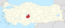 Location of the province within Turkey
| |
| Country | Turkey |
| Seat | Aksaray |
| Government | |
| • Vali | Mehmet Ali Kumbuzoğlu |
| Area | 7,659 km2 (2,957 sq mi) |
| Population
(2022)
|
433,055 |
| • Density | 57/km2 (150/sq mi) |
| Time zone | TRT (UTC+3) |
| Area code | 0382 |
| Website | www |
Aksaray Province (Turkish: Aksaray ili) is a province in central Turkey. Its adjacent provinces are Konya along the west and south, Niğde to the southeast, Nevşehir to the east, and Kırşehir to the north. Its area is 7,659 km2, and its population is 433,055 (2022). The provincial capital is the city of Aksaray.
Aksaray is one of the four provinces in Cappadocia, along with Nevşehir, Niğde, and Kayseri. Also, the 3,000-metre (9,843 ft) volcano Mount Hasan stands between Aksaray and Niğde. Summers are hot and dry on the plain, but the area is green and covered in flowers in springtime, when water streams off the mountainside. The 2,400 m2 salt lake (0.59 acres), Tuz Gölü, lies within the boundaries of Aksaray, a large swamp area with a maximum depth of 1 metre (3 ft 3 in).
Districts

Aksaray province is divided into 8 districts (capital district in bold):
Etymology
In antiquity the area was named Archelais Garsaura, which was mutated to Taksara during the Seljuk Turkish era, and then to Aksaray. Aksaray means "White Palace" in Turkish.
Aksaray Castle
The Aksaray Castle was a four-cornered, stone-built, solidly built castle on a large area on the edge of the Melendiz River. It was built in the middle of the city. The bastion and its towers were low. With all their bastions, teeth, and bodies, their crenelated holes and calculated towers always faced each other. During the siege, the strong warriors of each tower guarded the towers with rifles. There were five gates on the side of the fortresses. Küçükkapı faces west. Demirkapı opens to the qibla. Keçikapısı also opens towards the qibla. Ereğlikapısı opens to the south and Konyakapısı opens to the west. The guards of these gates are the tax collectors. The castle built a warehouse to store wheat during the rebels' time. It has no arsenal. Big balls are thrown during Ramadan and other festivals.
Population
| Year | Pop. | ±% p.a. |
|---|---|---|
| 1927 | 127,031 | — |
| 1990 | 326,399 | +1.51% |
| 2000 | 396,084 | +1.95% |
| 2010 | 377,505 | −0.48% |
| 2020 | 423,011 | +1.14% |
| Source:Turkstat | ||
History

The plains of central Anatolia have been settled for 8,000 years, and the area around Aksaray bears monuments to a string of civilisations that have settled on the plain in that time. The mound of Aşıklı Höyük in the town of Kızılkaya indicates a settlement dating back to 5,000BC (and also a skull of a woman who had apparently been trepanned, the earliest known record of brain surgery).
Later the Silk Road came through here so caravanserai and then larger and larger settlements were built to supply and shelter travellers and traders. The city and surroundings of Aksaray thrived in the Roman, Byzantine and the Turkish periods.

Today Aksaray is a rural, agricultural province, its people religious and conservative. Since the 1950s, many have moved to Europe as migrant workers. The population of Aksaray has long included a higher proportion of Kurdish people than most central Anatolian provinces. Many were resettled here from Tunceli, Diyarbakir , Adiyaman. and other eastern cities following the Sheikh Said rebellion in the 1920s.
Places of interest
- Aksaray Grand Mosque
- Red Minaret Mosque
- Aşıklı Höyük - a Neolithic settlement 25 km east of the city of Aksaray.
- Sultan Han - a large Seljuk caravanserai in the town of Sultanhani.
- Aksaray Museum
- Acemhöyük - an early Bronze Age settlement, 18 km north-west of the city of Aksaray.
- The ancient city of Nora, in the village of Helvadere near the city of Aksaray.
- Ihlara valley - a canyon, 40 km from the city of Aksaray, in the district of Güzelyurt
- Saratlı Kırkgöz Underground City
- St. Mercurius Underground City
- Taşpınar - known for rugs, 27 kilometres (17 mi) south of Aksaray
- Mount Hasan and Küçük Hasandağı
- Mokissos - ruins of an ancient city
- Helvadere Göleti
- Güzelyurt Dam Pond
- Sofular valley - an abandoned village in Gülağaç and Nenezi Dağı
- Bekar Sultan Tomb - located near the village of Bekar. The tomb was built in the 12th century during the Anatolian Seljuk period.
- Kalebalta - castle ruins.
- Ağzıkara Han
- Alayhan Caravanserai
- Tepesi Delik Han Caravanserai, formerly known as Öresun Han
- Lake Nar - a brackish lake separating Aksaray Province from Niğde
- Belisirma - a restaurant on the Melendiz River
- Sivişli Kilise - The St. Anargirios church, also known as Sivisli Church in Güzelyurt Monastery Valley
- St. Ayios Antonios Church - ruins in Çeltek, near Çanlı Kilise
- Karagedik Kilise - a ruined church in the village of Belisırma, formerly known as St. Ermolaos Church
- Selime Cathedral - a rock-cut cathedral in Güzelyürt, used as a castle during the reign of the Seljuks.
- Kilise Camii - Mosque Church, also known as the St. Gregory of Nazianzus Church in Güzelyurt
- Kizil Kilise - "Red Church", also known as St. Spyridon Church
- Çanlı Kilise - ruins of a medieval Byzantine church and settlement, located 15 kilometres (9.3 mi) southeast of Aksaray.
- Yüksek Kilise - the High church, also known as St. Analipsis (St. Panteleimon) Church
- Gökçe - St. Mamas Church & St. Michael the Archangel Churches
See also
Gallery
-

-
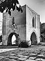
 St. Analipsis Church, also known as the "High Church".
 -
-
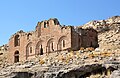 Çanlı Kilise, meaning 'Bell Church' southwest of Aksaray city.
 -
 A view of Ihlara valley, Aksaray
 -
 View of Ihlara town
 -
 Panoramic view towards Güzelyurt Monastery Valley and Church Mosque.
 -
 Monumental entrance of the Sultan Han
 -
 Interior of the Sultan Han Caravanserai
 -
 Selime Cathedral
 -
 Ulu Mosque, also known as The Aksaray Grand Mosque.
 -
 Aşıklı Höyük - a Neolithic settlement
 -
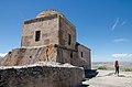
 Alayhan Caravanserai
 -
 Tepesi Delik Han Caravanserai, Aksaray Province


